Trail Walking Missy-sur-Aisne - Le fort de Condé - Photo
 tracegps
tracegps

User

© OpenStreetMap contributors
Length
Length
10.7 km
Max alt
Max alt
169 m
Uphill gradient
Uphill gradient
210 m
Km-Effort
Km-Effort  
13.5 km
Min alt
Min alt
59 m
Downhill gradient
Downhill gradient
210 m
Boucle
Boucle
Yes
Creation date :
2014-12-10 00:00:00.0
Updated on :
2014-12-10 00:00:00.0

(0 Reviews)

Walking
Walking
3h00
Difficulty : Very difficult

Scan this QR Code to open this trail in the SityTrail application

FREE GPS app for hiking

Logo SityTrail SityTrail

IGN / Geographical institutes

Download SityTrail from the App Store Download SityTrail from Google Play

Logo SityTrail SityTrail World

The world is yours!

Download SityTrail from the App Store Download SityTrail from Google Play Download SityTrail on Huawei AppGallery

About

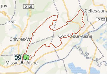
Trail Walking of 10.7 km to be discovered at Hauts-de-France, Aisne, Missy-sur-Aisne. This trail is proposed by tracegps.

Description

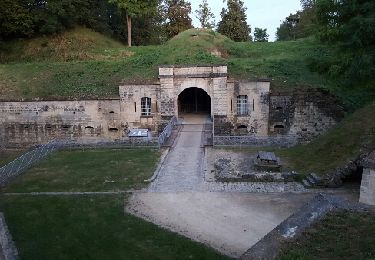
Cet itinéraire qui domine le confluent de l'Aisne et de la Vesle nous entraîne de la source Sainte-Radegonde au fort de Condé, "fort des hautes creuttes", comme l'appelaient les soldats, et qui appartenait au système défensif imaginé par le général Séré de Rivières. Toutes les infos sont ICI

Elevation profile

Photos

Positioning

Country:
France
Region :
Hauts-de-France
Department/Province :
Aisne
Municipality :
Missy-sur-Aisne
Location:
Unknown
Start:(UTM)
531708 ; 5470538 (31U) N.

Trails nearby

Trail Walking Venizel - Les rives de la vallée - Photo
Walking
tracegps

Walking

Medium
(1)
Venizel, Hauts-de-France, Aisne, France
10.8 km | 12 km-effort
2h 45min
Yes
Trail Walking Chivres-Val - Fort de condé - chivres - Photo
Walking
fitz2014

Walking

Very difficult
(1)
Chivres-Val, Hauts-de-France, Aisne, France
18 km | 22 km-effort
4h 48min
Yes
Trail Walking Chivres-Val - 11 la fontaine St ouen - Photo
Walking
fitz2014

Walking

Medium
Chivres-Val, Hauts-de-France, Aisne, France
14.1 km | 17.5 km-effort
3h 53min
Yes
Trail Walking Chivres-Val - Autour du fort de Condé - Photo
Walking

Walking

Very easy
Chivres-Val, Hauts-de-France, Aisne, France
939 m | 999 m-effort
Unknown
Yes
Trail Walking Bucy-le-Long - Détours et des tours - Photo
Walking

Walking

Very easy
Bucy-le-Long, Hauts-de-France, Aisne, France
7 km | 9 km-effort
Unknown
Yes
Trail Walking Chivres-Val - Chivres Val - La Fontaine de St Ouen - Photo
Walking
tracegps

Walking

Medium
Chivres-Val, Hauts-de-France, Aisne, France
12 km | 15.1 km-effort
4h 0min
No
Trail Walking Bucy-le-Long - Détours et des tours - Photo
Walking
tracegps

Walking

Medium
Bucy-le-Long, Hauts-de-France, Aisne, France
7 km | 9 km-effort
1h 45min
Yes
Trail Walking Chivres-Val - la fontaine de Saint - Ouen . - Photo
Walking
José800

Walking

Difficult
Chivres-Val, Hauts-de-France, Aisne, France
12.6 km | 15.7 km-effort
3h 33min
Yes
Trail Mountain bike Bucy-le-Long - Geocaching à Bucy le Long - Photo
Mountain bike
tracegps

Mountain bike

Easy
Bucy-le-Long, Hauts-de-France, Aisne, France
5.8 km | 7 km-effort
30min
Yes


Close
My subscriptions