Trail Walking Gramat - Gorges de l'Alzou par Rocamadour - Photo

Gorges de l'Alzou par Rocamadour

 tracegps
tracegps

User

© OpenStreetMap contributors
Length
Length
17.6 km
Max alt
Max alt
329 m
Uphill gradient
Uphill gradient
345 m
Km-Effort
Km-Effort  
22 km
Min alt
Min alt
135 m
Downhill gradient
Downhill gradient
342 m
Boucle
Boucle
Yes
Creation date :
2014-12-10 00:00:00.0
Updated on :
2014-12-10 00:00:00.0

(0 Reviews)

Walking
Walking
6h19
Difficulty : Difficult

Scan this QR Code to open this trail in the SityTrail application

FREE GPS app for hiking

Logo SityTrail SityTrail

IGN / Geographical institutes

Download SityTrail from the App Store Download SityTrail from Google Play

Logo SityTrail SityTrail World

The world is yours!

Download SityTrail from the App Store Download SityTrail from Google Play Download SityTrail on Huawei AppGallery

About

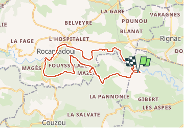
Trail Walking of 17.6 km to be discovered at Occitania, Lot, Gramat. This trail is proposed by tracegps.

Description

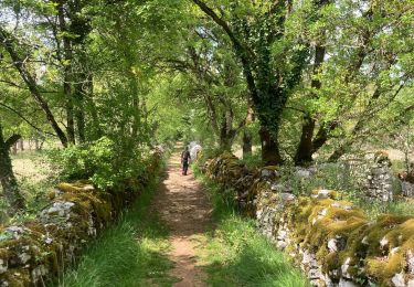
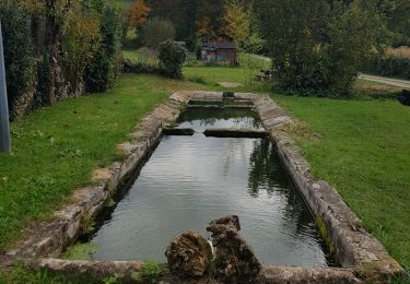
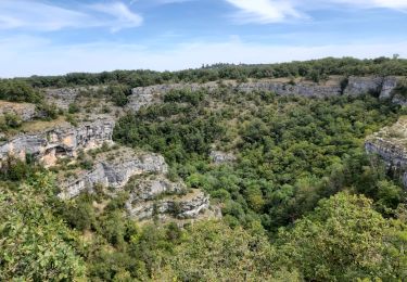
Les gorges de l'Alzou relient Gramat à Rocamadour et si vous êtes dans le coin, cette randonnée en boucle vaut le détour! Un mélange de verdure dans les gorges et de causse plus aride. 17.7km de balade, donc ne pas oublier les gourdes et de bonnes chaussures… La suite du récit, des photos et d’autres informations sont disponibles ICI Balade proposée par le site « Les Balades et Randonnées de Fred »

Elevation profile

Photos

Positioning

Country:
France
Region :
Occitania
Department/Province :
Lot
Municipality :
Gramat
Location:
Unknown
Start:(UTM)
395049 ; 4960339 (31T) N.

Trails nearby

Trail Walking Alvignac - Le grand tour d'Alvignac Les Eaux - Photo
Walking
tracegps

Walking

Difficult
(1)
Alvignac, Occitania, Lot, France
15.2 km | 19.3 km-effort
3h 49min
Yes
Trail Walking Gramat - Moulin du saut  - Photo
Walking
GUIDE
antignacs

Walking

Very easy
Gramat, Occitania, Lot, France
3.3 km | 4.2 km-effort
51min
Yes
Trail On foot Rocamadour - Boucle de randonnée entre Rocamadour et le Gouffre de Padirac - Photo
On foot
PRO

On foot

Very difficult
Rocamadour, Occitania, Lot, France
42 km | 53 km-effort
12h 2min
No
Trail Walking Rignac - Rignac - Photo
Walking
neleda

Walking

Easy
Rignac, Occitania, Lot, France
13.4 km | 17 km-effort
3h 3min
Yes
Trail Walking Rocamadour - SityTrail - Rocamadour  - Photo
Walking
houbart

Walking

Difficult
Rocamadour, Occitania, Lot, France
13.9 km | 17.8 km-effort
4h 2min
Yes
Trail Walking Gramat - alzou gorges - Photo
Walking
Forsans

Walking

Easy
Gramat, Occitania, Lot, France
5 km | 6.8 km-effort
1h 56min
Yes
Trail Walking Rocamadour - Rocamadour cougnaguet calouet - Photo
Walking
GUIDE
antignacs

Walking

Easy
Rocamadour, Occitania, Lot, France
17.7 km | 24 km-effort
4h 51min
Yes
Trail Walking Rocamadour - Rocamadour , magés , moulins du saut - Photo
Walking
bellouelo46

Walking

Easy
Rocamadour, Occitania, Lot, France
46 km | 56 km-effort
4h 41min
No
Trail Mountain bike Rocamadour - Rocamadour–Lacave 16/06/20 - Photo
Mountain bike
phibos

Mountain bike

Difficult
Rocamadour, Occitania, Lot, France
34 km | 43 km-effort
2h 55min
Yes


Close
My subscriptions