


Sous le Cuchon de Charance (Gap)

frizou83
User
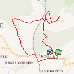

Length
5.1 km

Max alt
1558 m

Uphill gradient
416 m
Km-Effort
10.7 km

Min alt
1131 m

Downhill gradient
414 m
Boucle
Yes
Creation date :
2019-01-15 20:09:40.939
Updated on :
2019-01-15 20:09:40.939
2h06
Difficulty : Easy

FREE GPS app for hiking
 SityTrail
IGN / Geographical institutes
SityTrail Plus
The world is yours!
About
Trail Walking of 5.1 km to be discovered at Provence-Alpes-Côte d'Azur, Hautes-Alpes, Gap. This trail is proposed by frizou83.


Positioning
Country:
France
Region :
Provence-Alpes-Côte d'Azur
Department/Province :
Hautes-Alpes
Municipality :
Gap
Location:
Gap
Start:(Dec)
Start:(UTM)
263169 ; 4938375 (32T) N.
Comments