Gap, Hautes-Alpes: Best trails, routes and walks

16 comments

Gap: Discover the best trails: 185 hiking trails, 47 bike and mountain-bike routes and 1 equestrian circuits. All these trails, routes and outdoor activities are available in our SityTrail applications for smartphones and tablets.


The best trails (252)

Trail Walking Gap - Brèche et croix de Charance - Photo
Walking 8.553
Km
GUIDE

Walking

Easy
(1)
Gap, Provence-Alpes-Côte d'Azur, Hautes-Alpes, France
8.6 km | 18.5 km-effort
2h 13min
742 m
757 m
No
R@ph

Trail Walking Gap - 7 Chemin GAP - LA MOTTE DU CAIRE - Photo
Walking 40.744
Km
GUIDE

Walking

Very difficult
Gap, Provence-Alpes-Côte d'Azur, Hautes-Alpes, France
41 km | 60 km-effort
11h 0min
1390 m
1467 m
No
R@ph

Trail Walking Gap - R17   la Breche de Charance - Photo
Walking 6.346
Km
GUIDE+

Walking

Medium
Gap, Provence-Alpes-Côte d'Azur, Hautes-Alpes, France
6.3 km | 14.1 km-effort
2h 48min
583 m
582 m
Yes
Camping Les Rives du Lac

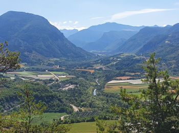
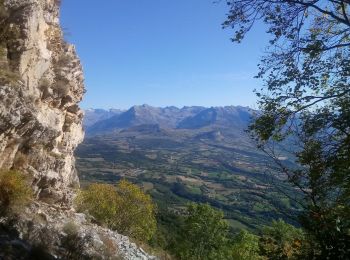
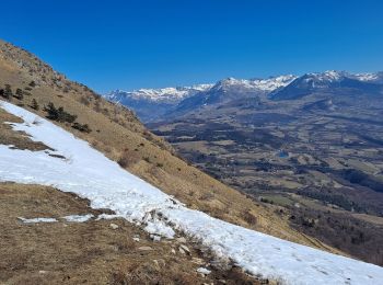
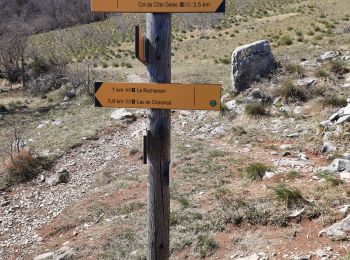
• Magnificent views of the Gapençais basin, the Pic de Bure, the Old Chaillol. Departure from the Castle of Charance wh...

Trail Walking Gap - R16   Le parc de Charance - Photo
Walking 3.616
Km
GUIDE+

Walking

Very easy
Gap, Provence-Alpes-Côte d'Azur, Hautes-Alpes, France
3.6 km | 5.2 km-effort
1h 8min
118 m
117 m
Yes
Camping Les Rives du Lac

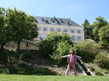
• Short hike in the Charance Park (with educational trail). Beautiful view of the gapençais basin from the gardens of t...

Trail Walking Gap - Brèche de Charance - Col de Gleize - Photo
Walking 8.046
Km
GUIDE

Walking

Difficult
Gap, Provence-Alpes-Côte d'Azur, Hautes-Alpes, France
8 km | 18.1 km-effort
2h 29min
894 m
336 m
No
R@ph

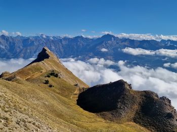
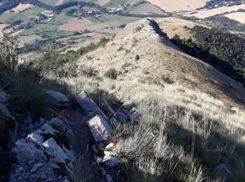
• Quelques passages délicats sur les crêtes

Trail Walking Gap - 3-pics-gleize_randonnee-40057005 - Photo
Walking 6.879
Km

Walking

Difficult
Gap, Provence-Alpes-Côte d'Azur, Hautes-Alpes, France
6.9 km | 13.7 km-effort
3h 6min
509 m
509 m
Yes
PapouBertrand

Trail Walking Gap - Pic de Charance - Photo
Walking 8.892
Km

Walking

Medium
Gap, Provence-Alpes-Côte d'Azur, Hautes-Alpes, France
8.9 km | 19 km-effort
4h 18min
757 m
757 m
Yes
Marco05

Trail Walking Gap - tête de guiziere. PC 1862. - Photo
Walking 14.115
Km

Walking

Medium
Gap, Provence-Alpes-Côte d'Azur, Hautes-Alpes, France
14.1 km | 27 km-effort
4h 18min
982 m
1014 m
No
gibello

Trail Walking Gap - Pic de Gleize - Photo
Walking 4.759
Km

Walking

Medium
Gap, Provence-Alpes-Côte d'Azur, Hautes-Alpes, France
4.8 km | 10.6 km-effort
2h 25min
441 m
442 m
Yes
Marco05

Trail Walking Gap - Cuchon-Pic de Charance - Photo
Walking 12.298
Km

Walking

Difficult
Gap, Provence-Alpes-Côte d'Azur, Hautes-Alpes, France
12.3 km | 24 km-effort
5h 32min
906 m
907 m
Yes
Marco05

Trail Walking Gap - Col de Guizière - Photo
Walking 8.725
Km

Walking

Medium
Gap, Provence-Alpes-Côte d'Azur, Hautes-Alpes, France
8.7 km | 17.5 km-effort
3h 58min
657 m
657 m
Yes
Marco05

Trail Walking Gap - 2021-09-28_502396886_Pic Melette - Photo
Walking 15.195
Km

Walking

Very difficult
(1)
Gap, Provence-Alpes-Côte d'Azur, Hautes-Alpes, France
15.2 km | 24 km-effort
5h 26min
654 m
655 m
Yes
PapouBertrand

Trail Walking Gap - pic melette - Photo
Walking 12.998
Km

Walking

Easy
Gap, Provence-Alpes-Côte d'Azur, Hautes-Alpes, France
13 km | 21 km-effort
6h 48min
589 m
587 m
Yes
gibello

Trail Road bike Gap - 3 cols montagne d aujour - Photo
Road bike 85.118
Km

Road bike

Difficult
Gap, Provence-Alpes-Côte d'Azur, Hautes-Alpes, France
85 km | 103 km-effort
3h 59min
1369 m
1371 m
Yes
gibello

Trail Walking Gap - cretes de charance - Photo
Walking 12.076
Km

Walking

Medium
Gap, Provence-Alpes-Côte d'Azur, Hautes-Alpes, France
12.1 km | 25 km-effort
5h 18min
966 m
964 m
Yes
gibello

Trail Walking Gap - gap charance - Photo
Walking 6.648
Km

Walking

Very easy
(1)
Gap, Provence-Alpes-Côte d'Azur, Hautes-Alpes, France
6.6 km | 10.8 km-effort
1h 49min
311 m
312 m
Yes
egolibre

Trail Walking Gap - Le Huchon et pic de Charance - Photo
Walking 11.302
Km

Walking

Medium
Gap, Provence-Alpes-Côte d'Azur, Hautes-Alpes, France
11.3 km | 0 m-effort
3h 35min
0 m
0 m
Yes
gibello

Trail Walking Gap - charance pic - Photo
Walking 10.329
Km

Walking

Medium
(1)
Gap, Provence-Alpes-Côte d'Azur, Hautes-Alpes, France
10.3 km | 21 km-effort
3h 37min
800 m
839 m
No
Gaetan53

Trail Walking Gap - le pic de gleize - Photo
Walking 9.521
Km

Walking

Medium
Gap, Provence-Alpes-Côte d'Azur, Hautes-Alpes, France
9.5 km | 17.5 km-effort
3h 14min
596 m
611 m
Yes
GILOU440

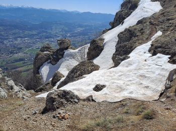
• très beau circuit. un peu de rochers retour sentier balcon magnifique.

Trail Walking Gap - Circuit de Malcombe - Photo
Walking 9.83
Km

Walking

Easy
Gap, Provence-Alpes-Côte d'Azur, Hautes-Alpes, France
9.8 km | 15 km-effort
3h 5min
379 m
405 m
No
frizou83

• Randonnée agréable offrant tout au long du parcours une diversité de paysages. Ne pas hésiter quand cela est possible...

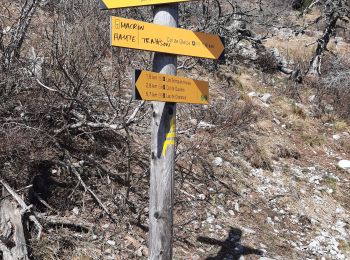
20 trails displayed on 252

FREE GPS app for hiking

Logo SityTrail SityTrail

IGN / Geographical institutes

Download SityTrail from the App Store Download SityTrail from Google Play

Logo SityTrail SityTrail World

The world is yours!

Download SityTrail from the App Store Download SityTrail from Google Play Download SityTrail on Huawei AppGallery

Activities

Nearby regions

Close
My subscriptions