


OuestCreuse N°18

xavlyd@orange.fr
User

Length
28 km

Max alt
438 m

Uphill gradient
463 m
Km-Effort
34 km

Min alt
291 m

Downhill gradient
463 m
Boucle
Yes
Creation date :
2019-01-15 20:14:42.475
Updated on :
2020-07-11 13:12:02.171
2h36
Difficulty : Medium

FREE GPS app for hiking
 SityTrail
IGN / Geographical institutes
SityTrail Plus
The world is yours!
About
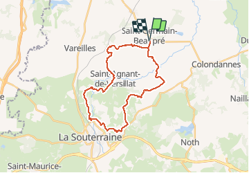
Trail Mountain bike of 28 km to be discovered at New Aquitaine, Creuse, Saint-Germain-Beaupré. This trail is proposed by xavlyd@orange.fr.
Positioning
Country:
France
Region :
New Aquitaine
Department/Province :
Creuse
Municipality :
Saint-Germain-Beaupré
Location:
Unknown
Start:(Dec)
Start:(UTM)
388047 ; 5128912 (31T) N.
Comments