![](/images/other/stat-length.png)
![Trail Walking Halluin - Du Kluit Put à la Lys - Halluin - Photo](https://media.geolcdn.com/t/1900/400/ext.pjpeg?maxdim=2&url=https%3A%2F%2Fservices.sitytrail.com%2FGeolivesWS%2FDownloadMedia.ashx%3FTrailID%3D109281%26Media%3D3410_6.jpg)
Du Kluit Put à la Lys - Halluin
tracegps
User
![Length](/images/other/stat-length.png)
Length
14 km
![Max alt](https://static1.geolcdn.com/siteimages/upload/files/1508320355ic_sort_altitude_max_24dp.png)
Max alt
42 m
![Uphill gradient](https://static1.geolcdn.com/siteimages/upload/files/1508320355ic_sort_den_pos_24dp.png)
Uphill gradient
97 m
![Km-Effort](/images/other/stat-length.png)
Km-Effort
15.3 km
![Min alt](https://static1.geolcdn.com/siteimages/upload/files/1508320355ic_sort_altitude_min_24dp.png)
Min alt
5 m
![Downhill gradient](https://static1.geolcdn.com/siteimages/upload/files/1508320355ic_sort_den_neg_24dp.png)
Downhill gradient
97 m
![Boucle](https://static1.geolcdn.com/siteimages/upload/files/16400158638029165_repeat_loop_refresh_sync_direction_icon.png)
Boucle
Yes
Creation date :
2014-12-10 00:00:00.0
Updated on :
2014-12-10 00:00:00.0
![Walking](https://static1.geolcdn.com/sitytour/trail-icons/101.png)
3h30
Difficulty : Difficult
![Scan this QR Code to open this trail in the SityTrail application](https://capi.geolives.com/qq0zvz2zws4bq2lad0pu/sitytour/trails/109281/qr.png?size=200)
FREE GPS app for hiking
About
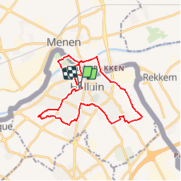
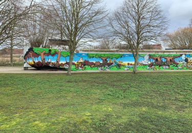
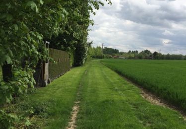
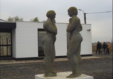
Trail Walking of 14 km to be discovered at Hauts-de-France, Nord, Halluin. This trail is proposed by tracegps.
Description
Départ de la mairie d’Halluin. Parcours franco belge qui fait découvrir le patrimoine et les espaces de détente de la ville d'Halluin et les berges de la Lys. Retrouvez cette randonnée sur le site du Comité Départemental du Tourisme du Nord.
Positioning
Country:
France
Region :
Hauts-de-France
Department/Province :
Nord
Municipality :
Halluin
Location:
Unknown
Start:(Dec)
Start:(UTM)
508737 ; 5625657 (31U) N.
Comments
Trails nearby
![Trail On foot Menin - Erfgoedwandelroute Menen - Photo](https://media.geolcdn.com/t/375/260/ext.jpg?maxdim=2&url=https%3A%2F%2Fmedia.geolcdn.com%2Ff%2Fa5418191-9e37-414e-a5c8-08ef3279a965.jpeg)
![On foot On foot](https://static1.geolcdn.com/sitytour/trail-icons/100.png)
Erfgoedwandelroute Menen
On foot
Easy
Menin,
Flanders,
West Flanders,
Belgium
![](/images/other/stat-length.png)
4 km | 4.3 km-effort
58min
![](https://static1.geolcdn.com/siteimages/upload/files/16400158638029165_repeat_loop_refresh_sync_direction_icon.png)
Yes
![Trail On foot Menin - Smokkelaarspad - Photo](https://media.geolcdn.com/t/375/260/ext.jpg?maxdim=2&url=https%3A%2F%2Fmedia.geolcdn.com%2Ff%2Fdfeb53ad-0f3e-45a5-b15b-6104366d05fc.jpeg)
![On foot On foot](https://static1.geolcdn.com/sitytour/trail-icons/100.png)
Smokkelaarspad
On foot
Easy
Menin,
Flanders,
West Flanders,
Belgium
![](/images/other/stat-length.png)
10.3 km | 11.2 km-effort
2h 32min
![](https://static1.geolcdn.com/siteimages/upload/files/16400158638029165_repeat_loop_refresh_sync_direction_icon.png)
Yes
![Trail On foot Menin - Kortewagenpad Lauwe - Photo](https://media.geolcdn.com/t/375/260/ext.jpg?maxdim=2&url=https%3A%2F%2Fmedia.geolcdn.com%2Ff%2Ff545b169-9dc5-48d6-bcd5-5fdbffb4f316.jpeg)
![On foot On foot](https://static1.geolcdn.com/sitytour/trail-icons/100.png)
Kortewagenpad Lauwe
On foot
Easy
Menin,
Flanders,
West Flanders,
Belgium
![](/images/other/stat-length.png)
13 km | 14.4 km-effort
3h 16min
![](https://static1.geolcdn.com/siteimages/upload/files/16400158638029165_repeat_loop_refresh_sync_direction_icon.png)
Yes
![Trail Walking Halluin - Halluin par le bout du monde (Deulémont) - Photo](https://media.geolcdn.com/t/375/260/ext.jpg?maxdim=2&url=https%3A%2F%2Fmedia.geolcdn.com%2Ff%2F8264ee1e-e7da-4aa2-8b7b-124af9b4bed9.jpg)
![Walking Walking](https://static1.geolcdn.com/sitytour/trail-icons/101.png)
Halluin par le bout du monde (Deulémont)
Walking
Medium
Halluin,
Hauts-de-France,
Nord,
France
![](/images/other/stat-length.png)
32 km | 34 km-effort
6h 12min
![](https://static1.geolcdn.com/siteimages/upload/files/16400158638029165_repeat_loop_refresh_sync_direction_icon.png)
No
![Trail Walking Menin - SityTrail - Compostelle - Nord 2 - Photo](https://media.geolcdn.com/t/375/260/ext.jpg?maxdim=2&url=https%3A%2F%2Fmedia.geolcdn.com%2Ff%2F7bbf4ec5-c0bd-43ab-b87f-80ac3217608f.jpeg)
![Walking Walking](https://static1.geolcdn.com/sitytour/trail-icons/101.png)
SityTrail - Compostelle - Nord 2
Walking
Very difficult
Menin,
Flanders,
West Flanders,
Belgium
![](/images/other/stat-length.png)
67 km | 73 km-effort
16h 18min
![](https://static1.geolcdn.com/siteimages/upload/files/16400158638029165_repeat_loop_refresh_sync_direction_icon.png)
No
![Trail Walking Menin - DKP2013 - Photo](https://media.geolcdn.com/t/375/260/ext.jpg?maxdim=2&url=https%3A%2F%2Fstatic1.geolcdn.com%2Fsiteimages%2Fupload%2Ffiles%2F1553511878bg_sport_marche.png)
![Walking Walking](https://static1.geolcdn.com/sitytour/trail-icons/101.png)
DKP2013
Walking
Very easy
(3)
Menin,
Flanders,
West Flanders,
Belgium
![](/images/other/stat-length.png)
7.7 km | 8.4 km-effort
1h 38min
![](https://static1.geolcdn.com/siteimages/upload/files/16400158638029165_repeat_loop_refresh_sync_direction_icon.png)
No
![Trail Walking Bousbecque - Circuit des Auger de Bousbecque - Photo](https://media.geolcdn.com/t/375/260/ext.jpg?maxdim=2&url=https%3A%2F%2Fservices.sitytrail.com%2FGeolivesWS%2FDownloadMedia.ashx%3FTrailID%3D109450%26Media%3D3899_3.jpg)
![Walking Walking](https://static1.geolcdn.com/sitytour/trail-icons/101.png)
Circuit des Auger de Bousbecque
Walking
Medium
(1)
Bousbecque,
Hauts-de-France,
Nord,
France
![](/images/other/stat-length.png)
13.3 km | 14.5 km-effort
3h 19min
![](https://static1.geolcdn.com/siteimages/upload/files/16400158638029165_repeat_loop_refresh_sync_direction_icon.png)
Yes
![Trail Walking Halluin - Boucle de la fraude du tabac - Halluin - Photo](https://media.geolcdn.com/t/375/260/ext.jpg?maxdim=2&url=https%3A%2F%2Fservices.sitytrail.com%2FGeolivesWS%2FDownloadMedia.ashx%3FTrailID%3D109277%26Media%3D3398_6.jpg)
![Walking Walking](https://static1.geolcdn.com/sitytour/trail-icons/101.png)
Boucle de la fraude du tabac - Halluin
Walking
Medium
(2)
Halluin,
Hauts-de-France,
Nord,
France
![](/images/other/stat-length.png)
9.3 km | 10.1 km-effort
2h 19min
![](https://static1.geolcdn.com/siteimages/upload/files/16400158638029165_repeat_loop_refresh_sync_direction_icon.png)
Yes
![Trail Walking Menin - Milpattes - 19112012 - Photo](https://media.geolcdn.com/t/375/260/ext.jpg?maxdim=2&url=https%3A%2F%2Fservices.sitytrail.com%2FGeolivesWS%2FDownloadMedia.ashx%3FTrailID%3D163481%26Media%3Dbc875ad0-3971-4ad9-ab3d-580b96ef771d.jpg)
![Walking Walking](https://static1.geolcdn.com/sitytour/trail-icons/101.png)
Milpattes - 19112012
Walking
Very easy
Menin,
Flanders,
West Flanders,
Belgium
![](/images/other/stat-length.png)
7.7 km | 8.3 km-effort
1h 49min
![](https://static1.geolcdn.com/siteimages/upload/files/16400158638029165_repeat_loop_refresh_sync_direction_icon.png)
Yes