Trail Walking Huelgoat - Autour de Huelgoat - Photo

Autour de Huelgoat

 tracegps
tracegps

User

© OpenStreetMap contributors
Length
Length
18 km
Max alt
Max alt
238 m
Uphill gradient
Uphill gradient
337 m
Km-Effort
Km-Effort  
23 km
Min alt
Min alt
94 m
Downhill gradient
Downhill gradient
337 m
Boucle
Boucle
Yes
Creation date :
2014-12-10 00:00:00.0
Updated on :
2014-12-10 00:00:00.0

(0 Reviews)

Walking
Walking
4h49
Difficulty : Medium

Scan this QR Code to open this trail in the SityTrail application

FREE GPS app for hiking

Logo SityTrail SityTrail

IGN / Geographical institutes

Download SityTrail from the App Store Download SityTrail from Google Play

Logo SityTrail SityTrail World

The world is yours!

Download SityTrail from the App Store Download SityTrail from Google Play Download SityTrail on Huawei AppGallery

About

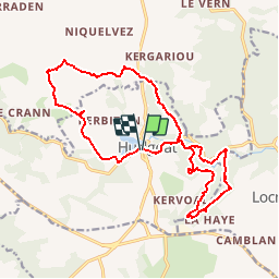
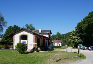
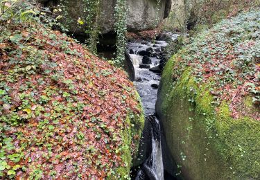
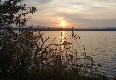
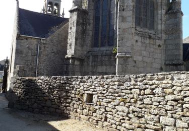
Trail Walking of 18 km to be discovered at Brittany, Finistère, Huelgoat. This trail is proposed by tracegps.

Description

Sur les Sentiers du Finistère - Autour de Huelgoat Sur Sentier Côtier, retrouvez les sentiers du Finistère à travers des parcours que Thierry et Françoise ont effectués. Numérisation des circuits réalisée sur le terrain. Les multiples sentiers de randonnées, très bien entretenus et balisés par la Communauté de communes des Monts d'Arrée, permettent de découvrir Huelgoat à pied, à cheval ou en vélo. Une agréable pause verte dans une extraordinaire nature préservée. Mise en garde de l’auteur : parfois des propriétés se construisent, des terrains deviennent inaccessibles ou des sentiers disparaissent faute d'être entretenus. Il faut donc quelquefois, même avec un GPS, improviser et modifier sa route pour ne pas fâcher un nouveau propriétaire récalcitrant. Ceux qui parcourent les chemins sont responsables de leur parcours et le tracé reste indicatif.

Elevation profile

Photos

Positioning

Country:
France
Region :
Brittany
Department/Province :
Finistère
Municipality :
Huelgoat
Location:
Unknown
Start:(UTM)
444554 ; 5356992 (30U) N.

Trails nearby

Trail Walking Berrien - Forêt de Huelgoat - Photo
Walking
Bobol

Walking

Medium
(1)
Berrien, Brittany, Finistère, France
12.7 km | 15.8 km-effort
3h 29min
Yes
Trail Walking Huelgoat - Huelgoat - Photo
Walking
dudu42

Walking

Very easy
(1)
Huelgoat, Brittany, Finistère, France
4.5 km | 5.9 km-effort
1h 7min
Yes
Trail Walking Huelgoat - Rando de Huelgoat - Photo
Walking
Jean LABADIE

Walking

Medium
(1)
Huelgoat, Brittany, Finistère, France
8.6 km | 10.6 km-effort
2h 24min
Yes
Trail Walking Huelgoat - Huelgoat  - Photo
Walking
Vasseur Jean Marc

Walking

Difficult
Huelgoat, Brittany, Finistère, France
13.7 km | 16.9 km-effort
3h 34min
No
Trail Electric bike Huelgoat - boucle Huelgoat forêt domaniale par voie verte - Photo
Electric bike
EricVIBERT

Electric bike

Easy
Huelgoat, Brittany, Finistère, France
28 km | 36 km-effort
5h 15min
No
Trail On foot Huelgoat - Circuit de la Mine Argentifère - Photo
On foot
PRO

On foot

Easy
Huelgoat, Brittany, Finistère, France
6 km | 7.5 km-effort
1h 42min
No
Trail Walking Poullaouen - Huelgoat Rando pittoresque - Photo
Walking
zefreefly

Walking

Easy
Poullaouen, Brittany, Finistère, France
18 km | 23 km-effort
4h 18min
Yes
Trail Walking Poullaouen - GR_37_ED_10_Poullaouen_Brennilis_20200809 - Photo
Walking
patrickdanilo

Walking

Very easy
Poullaouen, Brittany, Finistère, France
21 km | 26 km-effort
5h 47min
No
Trail Walking Huelgoat - Huelgoat , les curiosités, la forêt et retour le long du canal - Photo
Walking
MichelRando7656

Walking

Medium
Huelgoat, Brittany, Finistère, France
7.9 km | 9.7 km-effort
3h 32min
Yes


Close
My subscriptions