


champsaur, depart ancelle

gerardmicheline
User
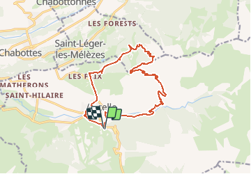

Length
16.7 km

Max alt
2195 m

Uphill gradient
912 m
Km-Effort
29 km

Min alt
1325 m

Downhill gradient
920 m
Boucle
Yes
Creation date :
2019-01-15 20:34:47.708
Updated on :
2021-01-10 15:05:58.126
5h51
Difficulty : Unknown

FREE GPS app for hiking
 SityTrail
IGN / Geographical institutes
SityTrail Plus
The world is yours!
About
Trail Walking of 16.7 km to be discovered at Provence-Alpes-Côte d'Azur, Hautes-Alpes, Ancelle. This trail is proposed by gerardmicheline.
Positioning
Country:
France
Region :
Provence-Alpes-Côte d'Azur
Department/Province :
Hautes-Alpes
Municipality :
Ancelle
Location:
Unknown
Start:(Dec)
Start:(UTM)
278792 ; 4944059 (32T) N.
Comments