Trail Walking Château-Porcien - Chemin de Compostelle, Voie de Vézelay GR654® De Château Porcien à Vieux lès Asfeld - Photo

Chemin de Compostelle, Voie de Vézelay GR654® De Château Porcien à Vieux lès Asfeld

 tracegps
tracegps

User

© OpenStreetMap contributors
Length
Length
14.5 km
Max alt
Max alt
73 m
Uphill gradient
Uphill gradient
76 m
Km-Effort
Km-Effort  
15.5 km
Min alt
Min alt
58 m
Downhill gradient
Downhill gradient
80 m
Boucle
Boucle
No
Creation date :
2014-12-10 00:00:00.0
Updated on :
2014-12-10 00:00:00.0

(0 Reviews)

Walking
Walking
3h00
Difficulty : Medium

Scan this QR Code to open this trail in the SityTrail application

FREE GPS app for hiking

Logo SityTrail SityTrail

IGN / Geographical institutes

Download SityTrail from the App Store Download SityTrail from Google Play

Logo SityTrail SityTrail World

The world is yours!

Download SityTrail from the App Store Download SityTrail from Google Play Download SityTrail on Huawei AppGallery

About

Trail Walking of 14.5 km to be discovered at Grand Est, Ardennes, Château-Porcien. This trail is proposed by tracegps.

Description

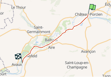
Le Chemin de Compostelle, voie de Vézelay GR654® présenté par le Comité Régional du Tourisme de Champagne-Ardenne. Chemin de Compostelle, Voie de Vézelay GR654® De Château Porcien à Vieux lès Asfeld. Cinquième étape. Cette étape facile longe la vallée de l’Aisne en utilisant principalement le chemin de halage du canal des Ardennes. Vous trouverez le descriptif détaillé de cette randonnée dans le Topo-guide® de la Fédération Française de la Randonnée Pédestre.

Elevation profile

Photos

Positioning

Country:
France
Region :
Grand Est
Department/Province :
Ardennes
Municipality :
Château-Porcien
Location:
Unknown
Start:(UTM)
590059 ; 5487047 (31U) N.

Trails nearby

Trail Nordic walking Château-Porcien - Château-Porcien à Boult-sur-Suippe - Photo
Nordic walking
BOUMA

Nordic walking

Very easy
Château-Porcien, Grand Est, Ardennes, France
27 km | 31 km-effort
5h 42min
No


Close
My subscriptions