Trail Walking Marillac-le-Franc - La randonnée de Marillac le Franc - Photo

La randonnée de Marillac le Franc

© OpenStreetMap contributors
Length
Length
8.4 km
Max alt
Max alt
194 m
Uphill gradient
Uphill gradient
105 m
Km-Effort
Km-Effort  
9.8 km
Min alt
Min alt
97 m
Downhill gradient
Downhill gradient
106 m
Boucle
Boucle
Yes
Creation date :
2019-01-15 20:41:23.622
Updated on :
2023-01-26 07:40:25.38

(2 Reviews)

Walking
Walking
2h28
Difficulty : Very easy

Scan this QR Code to open this trail in the SityTrail application

FREE GPS app for hiking

Logo SityTrail SityTrail

IGN / Geographical institutes

Download SityTrail from the App Store Download SityTrail from Google Play

Logo SityTrail SityTrail World

The world is yours!

Download SityTrail from the App Store Download SityTrail from Google Play Download SityTrail on Huawei AppGallery

About

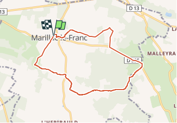
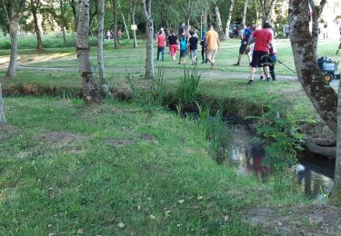
Trail Walking of 8.4 km to be discovered at New Aquitaine, Charente, Marillac-le-Franc. This trail is proposed by alainjoseph6.

Description

Une randonnée agréable, très belle et facile

Elevation profile

Photos

Points of interest

Point of interest Marillac-le-Franc - l'église des templiers đe malheyrand - Photo
alainjoseph6

Positioning

Country:
France
Region :
New Aquitaine
Department/Province :
Charente
Municipality :
Marillac-le-Franc
Location:
Unknown
Start:(UTM)
299876 ; 5067920 (31T) N.

Comments

Please log in to post a review or rate the element


Trails nearby

Trail Walking Moulins-sur-Tardoire - Rancogne ...le moulin de la pierre .. le moulin de la Forge  - Photo
Walking
alainjoseph6

Walking

Medium
Moulins-sur-Tardoire, New Aquitaine, Charente, France
7.5 km | 8.6 km-effort
2h 26min
Yes
Trail Walking Saint-Adjutory - Saint Adjutoy  16 110  avec un départ du Maine Cruvier  - Photo
Walking
alainjoseph6

Walking

Easy
Saint-Adjutory, New Aquitaine, Charente, France
7.9 km | 10.1 km-effort
2h 42min
Yes
Trail Walking Saint-Adjutory -  st adjutory  - Photo
Walking
Kraspouille

Walking

Very easy
Saint-Adjutory, New Aquitaine, Charente, France
10.8 km | 13.3 km-effort
3h 45min
Yes
Trail Walking Saint-Sornin - Le vignoble de St Sornin  - Photo
Walking
alainjoseph6

Walking

Easy
Saint-Sornin, New Aquitaine, Charente, France
9.9 km | 12.6 km-effort
2h 45min
Yes
Trail Walking Rivières - Une balade à Rivières  - Photo
Walking
alainjoseph6

Walking

Easy
Rivières, New Aquitaine, Charente, France
13.9 km | 15.7 km-effort
3h 33min
Yes
Trail Walking Taponnat-Fleurignac - De Taponnat à Fleurignac - Photo
Walking
alainjoseph6

Walking

Very easy
Taponnat-Fleurignac, New Aquitaine, Charente, France
9.3 km | 10.8 km-effort
2h 26min
Yes
Trail Walking Saint-Sornin - Saint-Sornin circuit des moulins - Photo
Walking
dorcier

Walking

Easy
Saint-Sornin, New Aquitaine, Charente, France
17.9 km | 22 km-effort
4h 43min
Yes
Trail Walking Moulins-sur-Tardoire - Le circuit de Rancogne - Photo
Walking
alainjoseph6

Walking

Very easy
(2)
Moulins-sur-Tardoire, New Aquitaine, Charente, France
9.1 km | 10.6 km-effort
2h 19min
Yes
Trail Walking Saint-Sornin - St Sornin charente  - Photo
Walking
alainjoseph6

Walking

Very easy
Saint-Sornin, New Aquitaine, Charente, France
10.7 km | 13.2 km-effort
2h 58min
Yes


Close
My subscriptions