Trail Walking Faverges-Seythenex - D'Albertville à Thônes 2/4 - La Dent de Cons - Photo

D'Albertville à Thônes 2/4 - La Dent de Cons

 tracegps
tracegps

User

© OpenStreetMap contributors
Length
Length
16.7 km
Max alt
Max alt
2041 m
Uphill gradient
Uphill gradient
1373 m
Km-Effort
Km-Effort  
36 km
Min alt
Min alt
467 m
Downhill gradient
Downhill gradient
1747 m
Boucle
Boucle
No
Creation date :
2014-12-10 00:00:00.0
Updated on :
2014-12-10 00:00:00.0

(1 Reviews)

Walking
Walking
8h30
Difficulty : Very difficult

Scan this QR Code to open this trail in the SityTrail application

FREE GPS app for hiking

Logo SityTrail SityTrail

IGN / Geographical institutes

Download SityTrail from the App Store Download SityTrail from Google Play

Logo SityTrail SityTrail World

The world is yours!

Download SityTrail from the App Store Download SityTrail from Google Play Download SityTrail on Huawei AppGallery

About

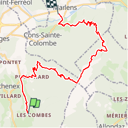
Trail Walking of 16.7 km to be discovered at Auvergne-Rhône-Alpes, Upper Savoy, Faverges-Seythenex. This trail is proposed by tracegps.

Description

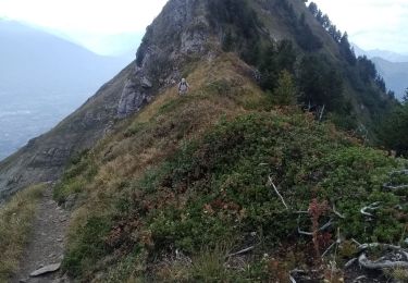
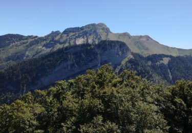
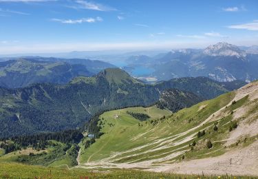
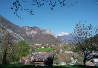
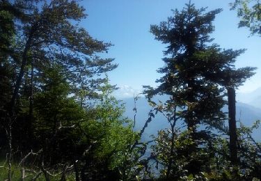
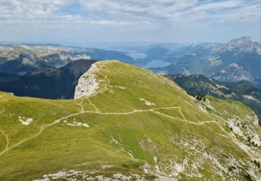
D'Albertville à Thônes 2/4 - La Dent de Cons. L'étape 2 de notre périple, un départ depuis le camping du hameau "Les combes" sur la commune de Seythenex, pour une arrivée au camping Champ Tillet situé sur la commune de Marlens. L'objectif de notre journée est l'ascension de la Dents de Cons, un sommet du massif des Bauges culminant à 2062 m d'altitude. Retrouvez toutes les informations nécessaires sur le site de la Communauté des Crapahuteurs.

Elevation profile

Photos

Positioning

Country:
France
Region :
Auvergne-Rhône-Alpes
Department/Province :
Upper Savoy
Municipality :
Faverges-Seythenex
Location:
Seythenex
Start:(UTM)
291088 ; 5065617 (32T) N.

Comments

Please log in to post a review or rate the element


Trails nearby

Trail Walking Plancherine - chalet de Drison à nant fourchu  - Photo
Walking
nadd73

Walking

Medium
Plancherine, Auvergne-Rhône-Alpes, Savoy, France
9.6 km | 18.3 km-effort
3h 23min
No
Trail Touring skiing Faverges-Seythenex - Petite et Grande Chaurionde - Photo
Touring skiing
nadd73

Touring skiing

Medium
Faverges-Seythenex, Auvergne-Rhône-Alpes, Upper Savoy, France
12.2 km | 29 km-effort
5h 15min
Yes
Trail Walking Marthod - Dent de Cons en boucle depuis Raffort - Photo
Walking
nadd73

Walking

Medium
Marthod, Auvergne-Rhône-Alpes, Savoy, France
8.5 km | 23 km-effort
4h 21min
No
Trail Walking Faverges-Seythenex - POINTE DU VELAN - Photo
Walking
Jean-Paulchoux

Walking

Medium
Faverges-Seythenex, Auvergne-Rhône-Alpes, Upper Savoy, France
11.2 km | 24 km-effort
3h 59min
Yes
Trail Walking Faverges-Seythenex - tour de Sambuy - Photo
Walking
marcagif

Walking

Difficult
Faverges-Seythenex, Auvergne-Rhône-Alpes, Upper Savoy, France
36 km | 58 km-effort
6h 26min
No
Trail Walking Faverges-Seythenex - la fosse a l'ours depuis Prafeu - Photo
Walking
COMAN

Walking

Easy
(1)
Faverges-Seythenex, Auvergne-Rhône-Alpes, Upper Savoy, France
4.7 km | 8.4 km-effort
1h 42min
Yes
Trail Walking Marthod - Le fort de la batterie - Photo
Walking
ochamley

Walking

Very easy
Marthod, Auvergne-Rhône-Alpes, Savoy, France
3.2 km | 6.9 km-effort
1h 2min
Yes
Trail Other activity Mercury - très vite - Photo
Other activity
arnaud.thery

Other activity

Very easy
Mercury, Auvergne-Rhône-Alpes, Savoy, France
31 km | 63 km-effort
2h 56min
No
Trail Walking Faverges-Seythenex - SAMBUY PAS DE L'OURS - Photo
Walking
Jean-Paulchoux

Walking

Difficult
Faverges-Seythenex, Auvergne-Rhône-Alpes, Upper Savoy, France
12.4 km | 27 km-effort
7h 5min
Yes


Close
My subscriptions