Trail Walking Xonrupt-Longemer - Le Hohneck et le sentier des roches - Du lac de Longemer au lac de Schiessrothried - Photo

Le Hohneck et le sentier des roches - Du lac de Longemer au lac de Schiessrothried

 tracegps
tracegps

User

© OpenStreetMap contributors
Length
Length
15.7 km
Max alt
Max alt
1342 m
Uphill gradient
Uphill gradient
986 m
Km-Effort
Km-Effort  
28 km
Min alt
Min alt
733 m
Downhill gradient
Downhill gradient
731 m
Boucle
Boucle
No
Creation date :
2014-12-10 00:00:00.0
Updated on :
2014-12-10 00:00:00.0

(1 Reviews)

Walking
Walking
7h00
Difficulty : Difficult

Scan this QR Code to open this trail in the SityTrail application

FREE GPS app for hiking

Logo SityTrail SityTrail

IGN / Geographical institutes

Download SityTrail from the App Store Download SityTrail from Google Play

Logo SityTrail SityTrail World

The world is yours!

Download SityTrail from the App Store Download SityTrail from Google Play Download SityTrail on Huawei AppGallery

About

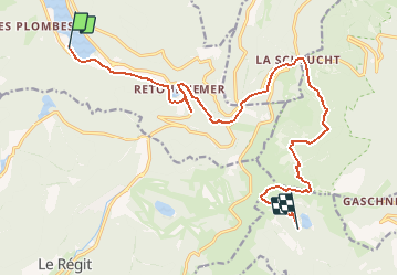
Trail Walking of 15.7 km to be discovered at Grand Est, Vosges, Xonrupt-Longemer. This trail is proposed by tracegps.

Description

Le Hohneck et le sentier des roches - Du lac de Longemer au lac de Schiessrothried. Randonnée en boucle sur 2 jours qui part des berges du lac de Longemer. Cette randonnée permet d'emprunter le fameux sentier des roches et de gravir le Hohneck, troisième plus haut sommet des Vosges (après le Grand Ballon et le Storkenkopf). Ce parcours ravira les amoureux d'eau car il croise un bon nombre de lacs et énormément de cours d'eau et rivières... Retrouvez toutes les informations nécessaires sur le site de la Communauté des Crapahuteurs.

Elevation profile

Photos

Positioning

Country:
France
Region :
Grand Est
Department/Province :
Vosges
Municipality :
Xonrupt-Longemer
Location:
Unknown
Start:(UTM)
347367 ; 5325712 (32U) N.

Comments

Please log in to post a review or rate the element


Trails nearby

Trail Walking La Bresse - Lac de Lispach et sentier Dielaine  - Photo
Walking
zazie

Walking

Medium
(1)
La Bresse, Grand Est, Vosges, France
9.7 km | 14.9 km-effort
2h 30min
Yes
Trail Walking La Bresse - Les 5 lacs autour du Hohneck - Photo
Walking
tiene

Walking

Very difficult
(1)
La Bresse, Grand Est, Vosges, France
21 km | 36 km-effort
7h 21min
Yes
Trail Walking La Bresse - lac de Lispach - Photo
Walking
fedinois1

Walking

Easy
(1)
La Bresse, Grand Est, Vosges, France
10.4 km | 14.1 km-effort
4h 6min
Yes
Trail Walking La Bresse - lac de Lispach - Photo
Walking
fedinois1

Walking

Easy
(3)
La Bresse, Grand Est, Vosges, France
10.4 km | 14.1 km-effort
4h 6min
Yes
Trail Walking Ban-sur-Meurthe-Clefcy - La vallée de Belbriette - Ban-sur-Meurthe-Clefcy - Photo
Walking
tracegps

Walking

Medium
(2)
Ban-sur-Meurthe-Clefcy, Grand Est, Vosges, France
9.8 km | 12.6 km-effort
2h 30min
Yes
Trail Walking La Bresse - Du Hohneck au Kastelberg par les Spietzkoepfe et le Sentier des Névées - Photo
Walking
tracegps

Walking

Very difficult
(3)
La Bresse, Grand Est, Vosges, France
7.6 km | 13.7 km-effort
3h 30min
Yes
Trail Walking Gérardmer - gerardmer - la mauselaine . tête grauvelin . Roche boquet . croix claudé . hautes Vannes . la mauselaine  - Photo
Walking
stef789

Walking

Very easy
(1)
Gérardmer, Grand Est, Vosges, France
11.3 km | 16.2 km-effort
3h 42min
Yes
Trail Walking Xonrupt-Longemer - 23-08-17 Lac Longemer - Lispach - Photo
Walking
annefrance70

Walking

Medium
(1)
Xonrupt-Longemer, Grand Est, Vosges, France
7 km | 12.1 km-effort
2h 13min
Yes
Trail Snowshoes Le Valtin - raquettes  - Photo
Snowshoes
vathi54

Snowshoes

Very easy
(1)
Le Valtin, Grand Est, Vosges, France
6.6 km | 9.4 km-effort
3h 8min
No


Close
My subscriptions