Trail Walking Neufchâteau - La grotte de l'Enfer (Neufchâteau) - Photo

La grotte de l'Enfer (Neufchâteau)

 tracegps
tracegps

User

© OpenStreetMap contributors
Length
Length
11.6 km
Max alt
Max alt
352 m
Uphill gradient
Uphill gradient
170 m
Km-Effort
Km-Effort  
13.8 km
Min alt
Min alt
278 m
Downhill gradient
Downhill gradient
170 m
Boucle
Boucle
Yes
Creation date :
2014-12-10 00:00:00.0
Updated on :
2014-12-10 00:00:00.0

(1 Reviews)

Walking
Walking
3h00
Difficulty : Medium

Scan this QR Code to open this trail in the SityTrail application

FREE GPS app for hiking

Logo SityTrail SityTrail

IGN / Geographical institutes

Download SityTrail from the App Store Download SityTrail from Google Play

Logo SityTrail SityTrail World

The world is yours!

Download SityTrail from the App Store Download SityTrail from Google Play Download SityTrail on Huawei AppGallery

About

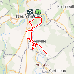
Trail Walking of 11.6 km to be discovered at Grand Est, Vosges, Neufchâteau. This trail is proposed by tracegps.

Description

Circuit proposé par le Comité Départemental du Tourisme des Vosges et l’Office du Tourisme de Neufchâteau . Départ : Esplanade des Marronniers à Neufchâteau. Située à la confluence de deux vallées bien tranquilles, celle de la Meuse et du Mouzon, Neufchâteau est une charmante ville, dynamique et commerçante. Jouissant d’un riche patrimoine architectural issu d’un glorieux passé, Neufchâteau et ses alentours offrent de nombreuses possibilités de découvertes et de randonnées. Retrouvez le descriptif et la carte sur le site du Comité Départemental du Tourisme des Vosges. Rappel : Dans le massif Vosgien, n’oubliez pas de vous munir de la carte IGN avec le balisage du Club Vosgien. Ce circuit a été numérisé par les randonneurs du CODEPEM. Merci à Jean-Marie.

Elevation profile

Photos

Positioning

Country:
France
Region :
Grand Est
Department/Province :
Vosges
Municipality :
Neufchâteau
Location:
Unknown
Start:(UTM)
700113 ; 5359119 (31U) N.

Comments

Please log in to post a review or rate the element


Trails nearby

Trail Walking Rollainville - A la découverte de la forêt de Neufeys - Photo
Walking
mannequ1

Walking

Very easy
(1)
Rollainville, Grand Est, Vosges, France
14.7 km | 18.3 km-effort
3h 27min
Yes
Trail On foot Rollainville - Sentier de la Frézelle - Photo
On foot
PRO

On foot

Easy
Rollainville, Grand Est, Vosges, France
10.5 km | 12.7 km-effort
2h 53min
Yes
Trail Walking Rollainville - circuit  - Photo
Walking
CDSM 55

Walking

Medium
Rollainville, Grand Est, Vosges, France
7.9 km | 9.7 km-effort
1h 41min
Yes
Trail On foot Rollainville - Sentier de Neufeys - Photo
On foot
PRO

On foot

Easy
Rollainville, Grand Est, Vosges, France
3.6 km | 4.6 km-effort
1h 2min
No
Trail Walking Neufchâteau - sentiers de la pelouse calcaire et de Neufeys - Photo
Walking
Samuel88300

Walking

Easy
Neufchâteau, Grand Est, Vosges, France
22 km | 27 km-effort
7h 42min
Yes
Trail Hybrid bike Neufchâteau - neufchateau  - Photo
Hybrid bike
famiski

Hybrid bike

Very easy
Neufchâteau, Grand Est, Vosges, France
41 km | 46 km-effort
3h 50min
No
Trail Walking Neufchâteau - marche de jeudi  - Photo
Walking
lamiche88

Walking

Easy
Neufchâteau, Grand Est, Vosges, France
13.6 km | 15.7 km-effort
3h 7min
Yes
Trail Walking Neufchâteau - circuit neufchateau 15km - Photo
Walking
lamiche88

Walking

Easy
Neufchâteau, Grand Est, Vosges, France
14.6 km | 17.4 km-effort
3h 24min
No
Trail Walking Neufchâteau - neufchateau 15km - Photo
Walking
lamiche88

Walking

Easy
Neufchâteau, Grand Est, Vosges, France
14.9 km | 18.4 km-effort
3h 14min
No


Close
My subscriptions