Trail Walking Xonrupt-Longemer - De Longemer à Lispach - Photo

De Longemer à Lispach

 tracegps
tracegps

User

© OpenStreetMap contributors
Length
Length
8.4 km
Max alt
Max alt
1089 m
Uphill gradient
Uphill gradient
528 m
Km-Effort
Km-Effort  
15.4 km
Min alt
Min alt
746 m
Downhill gradient
Downhill gradient
528 m
Boucle
Boucle
Yes
Creation date :
2014-12-10 00:00:00.0
Updated on :
2014-12-10 00:00:00.0

(1 Reviews)

Walking
Walking
3h30
Difficulty : Medium

Scan this QR Code to open this trail in the SityTrail application

FREE GPS app for hiking

Logo SityTrail SityTrail

IGN / Geographical institutes

Download SityTrail from the App Store Download SityTrail from Google Play

Logo SityTrail SityTrail World

The world is yours!

Download SityTrail from the App Store Download SityTrail from Google Play Download SityTrail on Huawei AppGallery

About

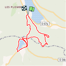
Trail Walking of 8.4 km to be discovered at Grand Est, Vosges, Xonrupt-Longemer. This trail is proposed by tracegps.

Description

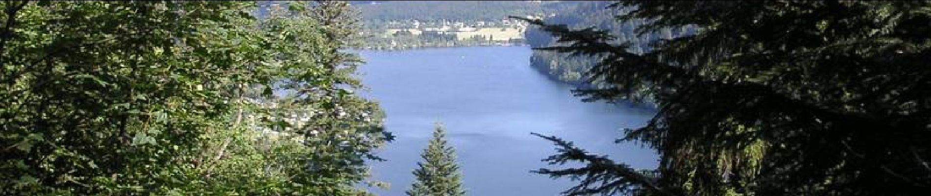
Parking le long du lac de Longemer sur la D67 , départ de la randonnée près du camping « les jonquilles ». Facilité de stationnement par place de parking tout du long de la D67. Début de la randonnée vers la boule du diable balisé disque jaune, on monte vers ce dôme de granit avec une vue superbe sur le lac de Longemer, on serpente entre les arbres prés du point culminant on quitte ce sentier pour prendre celui balisé disque rouge et on trouve la boule du diable sur notre randonnée… La suite et d’autres informations et photos sur le site des Balades de Stéphane.

Elevation profile

Photos

Positioning

Country:
France
Region :
Grand Est
Department/Province :
Vosges
Municipality :
Xonrupt-Longemer
Location:
Unknown
Start:(UTM)
347191 ; 5325813 (32U) N.

Comments

Please log in to post a review or rate the element


Trails nearby

Trail Walking La Bresse - Lac de Lispach et sentier Dielaine  - Photo
Walking
zazie

Walking

Medium
(1)
La Bresse, Grand Est, Vosges, France
9.7 km | 14.9 km-effort
2h 30min
Yes
Trail Walking La Bresse - Les 5 lacs autour du Hohneck - Photo
Walking
tiene

Walking

Very difficult
(1)
La Bresse, Grand Est, Vosges, France
21 km | 36 km-effort
7h 21min
Yes
Trail Walking La Bresse - lac de Lispach - Photo
Walking
fedinois1

Walking

Easy
(1)
La Bresse, Grand Est, Vosges, France
10.4 km | 14.1 km-effort
4h 6min
Yes
Trail Walking La Bresse - lac de Lispach - Photo
Walking
fedinois1

Walking

Easy
(3)
La Bresse, Grand Est, Vosges, France
10.4 km | 14.1 km-effort
4h 6min
Yes
Trail Walking Ban-sur-Meurthe-Clefcy - La vallée de Belbriette - Ban-sur-Meurthe-Clefcy - Photo
Walking
tracegps

Walking

Medium
(2)
Ban-sur-Meurthe-Clefcy, Grand Est, Vosges, France
9.8 km | 12.6 km-effort
2h 30min
Yes
Trail Walking La Bresse - Du Hohneck au Kastelberg par les Spietzkoepfe et le Sentier des Névées - Photo
Walking
tracegps

Walking

Very difficult
(3)
La Bresse, Grand Est, Vosges, France
7.6 km | 13.7 km-effort
3h 30min
Yes
Trail Walking Gérardmer - gerardmer - la mauselaine . tête grauvelin . Roche boquet . croix claudé . hautes Vannes . la mauselaine  - Photo
Walking
stef789

Walking

Very easy
(1)
Gérardmer, Grand Est, Vosges, France
11.3 km | 16.2 km-effort
3h 42min
Yes
Trail Walking Xonrupt-Longemer - 23-08-17 Lac Longemer - Lispach - Photo
Walking
annefrance70

Walking

Medium
(1)
Xonrupt-Longemer, Grand Est, Vosges, France
7 km | 12.1 km-effort
2h 13min
Yes
Trail Snowshoes Le Valtin - raquettes  - Photo
Snowshoes
vathi54

Snowshoes

Very easy
(1)
Le Valtin, Grand Est, Vosges, France
6.6 km | 9.4 km-effort
3h 8min
No


Close
My subscriptions