


meouge

Nathy8913
User
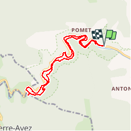

Length
10.9 km

Max alt
684 m

Uphill gradient
303 m
Km-Effort
15 km

Min alt
554 m

Downhill gradient
310 m
Boucle
Yes
Creation date :
2019-05-06 10:25:05.358
Updated on :
2019-05-06 10:25:05.358
5h50
Difficulty : Unknown

FREE GPS app for hiking
 SityTrail
IGN / Geographical institutes
SityTrail Plus
The world is yours!
About
Trail Walking of 10.9 km to be discovered at Provence-Alpes-Côte d'Azur, Hautes-Alpes, Val-Buëch-Méouge. This trail is proposed by Nathy8913.
Description
moyeb
Positioning
Country:
France
Region :
Provence-Alpes-Côte d'Azur
Department/Province :
Hautes-Alpes
Municipality :
Val-Buëch-Méouge
Location:
Châteauneuf-de-Chabre
Start:(Dec)
Start:(UTM)
723096 ; 4906414 (31T) N.
Comments