Val-Buëch-Méouge, Hautes-Alpes: Best trails, routes and walks

6 comments

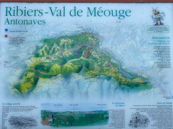
Val-Buëch-Méouge: Discover the best trails: 98 hiking trails and 18 bike and mountain-bike routes. All these trails, routes and outdoor activities are available in our SityTrail applications for smartphones and tablets.


The best trails (116)

Trail Walking Val-Buëch-Méouge - les gorges de la Méouge - Photo
Walking 13.119
Km
GUIDE

Walking

Medium
Val-Buëch-Méouge, Provence-Alpes-Côte d'Azur, Hautes-Alpes, France
13.1 km | 21 km-effort
5h 40min
609 m
609 m
Yes
amiral13

Trail Walking Val-Buëch-Méouge - SityTrail - PF-Antonaves - Les Gorges de la Méouge - Photo
Walking 13.26
Km

Walking

Medium
(1)
Val-Buëch-Méouge, Provence-Alpes-Côte d'Azur, Hautes-Alpes, France
13.3 km | 21 km-effort
4h 22min
597 m
598 m
Yes
raymondfn

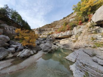
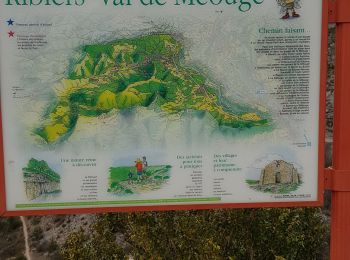
• La Méouge est une rivière du sud-est de la France qui prend sa source dans la Drôme sur la commune de Barret-de-Liour...

Trail Walking Val-Buëch-Méouge - Anti a es - Photo
Walking 13.47
Km
GUIDE

Walking

Very difficult
Val-Buëch-Méouge, Provence-Alpes-Côte d'Azur, Hautes-Alpes, France
13.5 km | 25 km-effort
5h 3min
851 m
852 m
Yes
Roger Philippe Wallez

Trail Walking Val-Buëch-Méouge - Rocher de pierre Impie, roc de l'aigle,  pas de Berches  - Photo
Walking 12.409
Km

Walking

Medium
Val-Buëch-Méouge, Provence-Alpes-Côte d'Azur, Hautes-Alpes, France
12.4 km | 23 km-effort
6h 1min
760 m
789 m
No
nadd73

Trail Walking Val-Buëch-Méouge - Gorges de la Méouge - Photo
Walking 11.857
Km

Walking

Difficult
Val-Buëch-Méouge, Provence-Alpes-Côte d'Azur, Hautes-Alpes, France
11.9 km | 19.5 km-effort
4h 26min
576 m
568 m
Yes
Marco05

Trail Walking Val-Buëch-Méouge - Pic de Saint-Cyr - Photo
Walking 10.682
Km

Walking

Medium
Val-Buëch-Méouge, Provence-Alpes-Côte d'Azur, Hautes-Alpes, France
10.7 km | 20 km-effort
4h 21min
718 m
718 m
Yes
Marco05

Trail Walking Val-Buëch-Méouge - ANTONAVES,  LES GORGES DE LA MEOUGE ,  ROCHER DU CHATEAU o s - Photo
Walking 11.021
Km

Walking

Medium
(1)
Val-Buëch-Méouge, Provence-Alpes-Côte d'Azur, Hautes-Alpes, France
11 km | 17.2 km-effort
3h 12min
461 m
465 m
Yes
RobinMicheline

Trail Walking Val-Buëch-Méouge - Boucle du Mt Ourouze depart Antonaves 415 + - Photo
Walking 10.93
Km

Walking

Easy
Val-Buëch-Méouge, Provence-Alpes-Côte d'Azur, Hautes-Alpes, France
10.9 km | 16.5 km-effort
13h 7min
415 m
417 m
Yes
claude nier

Trail Hybrid bike Val-Buëch-Méouge - Gorge de la Meouge et Chabre depart Ribiers  702 + - Photo
Hybrid bike 40.32
Km

Hybrid bike

Easy
Val-Buëch-Méouge, Provence-Alpes-Côte d'Azur, Hautes-Alpes, France
40 km | 50 km-effort
5h 41min
702 m
704 m
Yes
claude nier

Trail Hybrid bike Val-Buëch-Méouge - Chabre depar Ribiers  +918 - Photo
Hybrid bike 34.82
Km

Hybrid bike

Easy
Val-Buëch-Méouge, Provence-Alpes-Côte d'Azur, Hautes-Alpes, France
35 km | 47 km-effort
2h 17min
918 m
918 m
Yes
claude nier

Trail Walking Val-Buëch-Méouge - Boucle du Mont Ourouze depart Anthonave - Photo
Walking 9.669
Km

Walking

Easy
Val-Buëch-Méouge, Provence-Alpes-Côte d'Azur, Hautes-Alpes, France
9.7 km | 15.2 km-effort
3h 47min
418 m
418 m
Yes
claude nier

Trail Walking Val-Buëch-Méouge - Les Batos depart Ribiers - Photo
Walking 9.54
Km

Walking

Easy
Val-Buëch-Méouge, Provence-Alpes-Côte d'Azur, Hautes-Alpes, France
9.5 km | 13.9 km-effort
2h 36min
330 m
330 m
Yes
claude nier

Trail Walking Val-Buëch-Méouge - Covid 24 - Photo
Walking 6.185
Km

Walking

Easy
Val-Buëch-Méouge, Provence-Alpes-Côte d'Azur, Hautes-Alpes, France
6.2 km | 7.9 km-effort
1h 30min
129 m
134 m
No
claude nier

Trail Walking Val-Buëch-Méouge - Covid 23 - Photo
Walking 7.061
Km

Walking

Very easy
Val-Buëch-Méouge, Provence-Alpes-Côte d'Azur, Hautes-Alpes, France
7.1 km | 8.2 km-effort
2h 2min
85 m
84 m
Yes
claude nier

Trail Walking Val-Buëch-Méouge - Covid 22 - Photo
Walking 6.741
Km

Walking

Easy
Val-Buëch-Méouge, Provence-Alpes-Côte d'Azur, Hautes-Alpes, France
6.7 km | 7.6 km-effort
1h 40min
67 m
71 m
Yes
claude nier

Trail Walking Val-Buëch-Méouge - Covid 20 - Photo
Walking 8.802
Km

Walking

Very easy
Val-Buëch-Méouge, Provence-Alpes-Côte d'Azur, Hautes-Alpes, France
8.8 km | 10.6 km-effort
2h 4min
137 m
137 m
Yes
claude nier

Trail Walking Val-Buëch-Méouge - CHATEAU NEUF DE CHABRE 05 . Piloubeau , les cretes de Chabre o s - Photo
Walking 14.801
Km

Walking

Difficult
Val-Buëch-Méouge, Provence-Alpes-Côte d'Azur, Hautes-Alpes, France
14.8 km | 24 km-effort
6h 11min
707 m
708 m
Yes
RobinMicheline

Trail Walking Val-Buëch-Méouge - le rocher du château, les gorges de Meouge - Photo
Walking 13.747
Km

Walking

Medium
Val-Buëch-Méouge, Provence-Alpes-Côte d'Azur, Hautes-Alpes, France
13.7 km | 23 km-effort
4h 52min
670 m
673 m
Yes
nadd73

Trail Walking Val-Buëch-Méouge - Pic Saint Cyr - Photo
Walking 10.502
Km

Walking

Medium
Val-Buëch-Méouge, Provence-Alpes-Côte d'Azur, Hautes-Alpes, France
10.5 km | 18.9 km-effort
4h 53min
598 m
722 m
No
aubr

Trail Walking Val-Buëch-Méouge - PF-Antonaves - Les Gorges de la Méouge - Photo
Walking 13.024
Km

Walking

Very difficult
(1)
Val-Buëch-Méouge, Provence-Alpes-Côte d'Azur, Hautes-Alpes, France
13 km | 22 km-effort
5h 16min
654 m
656 m
Yes
MicDul

20 trails displayed on 116

FREE GPS app for hiking

Logo SityTrail SityTrail

IGN / Geographical institutes

Download SityTrail from the App Store Download SityTrail from Google Play

Logo SityTrail SityTrail World

The world is yours!

Download SityTrail from the App Store Download SityTrail from Google Play Download SityTrail on Huawei AppGallery

Activities

Nearby regions

Close
My subscriptions