Trail Walking Valmondois - Vallée de Nesles - Photo
 tracegps
tracegps

User

© OpenStreetMap contributors
Length
Length
23 km
Max alt
Max alt
97 m
Uphill gradient
Uphill gradient
360 m
Km-Effort
Km-Effort  
28 km
Min alt
Min alt
22 m
Downhill gradient
Downhill gradient
360 m
Boucle
Boucle
Yes
Creation date :
2014-12-10 00:00:00.0
Updated on :
2014-12-10 00:00:00.0

(1 Reviews)

Walking
Walking
4h45
Difficulty : Difficult

Scan this QR Code to open this trail in the SityTrail application

FREE GPS app for hiking

Logo SityTrail SityTrail

IGN / Geographical institutes

Download SityTrail from the App Store Download SityTrail from Google Play

Logo SityTrail SityTrail World

The world is yours!

Download SityTrail from the App Store Download SityTrail from Google Play Download SityTrail on Huawei AppGallery

About

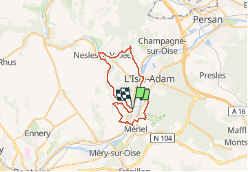
Trail Walking of 23 km to be discovered at Ile-de-France, Val-d'Oise, Valmondois. This trail is proposed by tracegps.

Description

Circuit proposé par le Comité Départemental de Randonnée des Hauts de Seine. Parking Départ : gare de Valmondois Descriptif : PR13, Valmondois, les Grands Prés, Côte d'Orgivaux, la Rue Dorée, le Carrouge, la Nase .... GR1, Nesles-la-Vallée, Jouy le Comte, Parmain, L’Isle-Adam (12 km), le Vivray, le Pré Fleuri.... PR14, Coteau de l'Etang.... nb, le Port aux moines 400m .... PR, Mériel, Butry le Chemin Vert , Valmondois. Des sentiers ont pu être modifiés depuis la dernière validation et les itinéraires proposés n’engagent pas la responsabilité du Comité. Signalez-nous les modifications rencontrées pour mise à jour de la randothèque.

Elevation profile

Photos

Positioning

Country:
France
Region :
Ile-de-France
Department/Province :
Val-d'Oise
Municipality :
Valmondois
Location:
Unknown
Start:(UTM)
441745 ; 5438018 (31U) N.

Comments

Please log in to post a review or rate the element


Trails nearby

Trail Walking Parmain - L Parmain jean Sarment a Valmondoit - Photo
Walking
avdem

Walking

Very easy
(1)
Parmain, Ile-de-France, Val-d'Oise, France
7.9 km | 9.5 km-effort
2h 10min
Yes
Trail Walking L'Isle-Adam - Autour de l'Isle Adam - Photo
Walking
tracegps

Walking

Difficult
(1)
L'Isle-Adam, Ile-de-France, Val-d'Oise, France
22 km | 26 km-effort
4h 30min
Yes
Trail On foot L'Isle-Adam - L'Isle-Adam 02 L'Isle Adam - Photo
On foot
Claudyo

On foot

Very easy
(1)
L'Isle-Adam, Ile-de-France, Val-d'Oise, France
9.4 km | 10.7 km-effort
3h 0min
Yes
Trail Walking Champagne-sur-Oise - Autour de Parmain - Photo
Walking
tracegps

Walking

Medium
(1)
Champagne-sur-Oise, Ile-de-France, Val-d'Oise, France
18.9 km | 23 km-effort
4h 0min
No
Trail Walking Méry-sur-Oise - Méry sur OIse- Neuville université - Photo
Walking
chessyca

Walking

Very easy
Méry-sur-Oise, Ile-de-France, Val-d'Oise, France
15.6 km | 17.7 km-effort
3h 37min
No
Trail Walking Labbeville - labeville  vallongoujard wmezieres - Photo
Walking
avdem

Walking

Easy
Labbeville, Ile-de-France, Val-d'Oise, France
11.1 km | 13.1 km-effort
3h 8min
Yes
Trail Walking Valmondois - Valmondois Mesles - Photo
Walking
avdem

Walking

Easy
Valmondois, Ile-de-France, Val-d'Oise, France
11 km | 13.6 km-effort
2h 42min
Yes
Trail Walking Parmain - Hedouville Frouville Nesle la Valee - Photo
Walking
avdem

Walking

Very easy
Parmain, Ile-de-France, Val-d'Oise, France
14.7 km | 17.7 km-effort
3h 30min
Yes
Trail Walking Parmain - Tour du Lay , Ronquerolle - Photo
Walking
avdem

Walking

Very easy
Parmain, Ile-de-France, Val-d'Oise, France
12.5 km | 15.8 km-effort
3h 11min
Yes


Close
My subscriptions