Trail Walking Saint-Jacques-en-Valgodemard - Tour du Vieux Chaillol 1/5 - Gite Les Paris au Gite Le Casset - Photo

Tour du Vieux Chaillol 1/5 - Gite Les Paris au Gite Le Casset

 tracegps
tracegps

User

© OpenStreetMap contributors
Length
Length
20 km
Max alt
Max alt
1152 m
Uphill gradient
Uphill gradient
564 m
Km-Effort
Km-Effort  
27 km
Min alt
Min alt
906 m
Downhill gradient
Downhill gradient
396 m
Boucle
Boucle
No
Creation date :
2014-12-10 00:00:00.0
Updated on :
2014-12-10 00:00:00.0

(1 Reviews)

Walking
Walking
6h30
Difficulty : Medium

Scan this QR Code to open this trail in the SityTrail application

FREE GPS app for hiking

Logo SityTrail SityTrail

IGN / Geographical institutes

Download SityTrail from the App Store Download SityTrail from Google Play

Logo SityTrail SityTrail World

The world is yours!

Download SityTrail from the App Store Download SityTrail from Google Play Download SityTrail on Huawei AppGallery

About

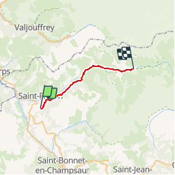
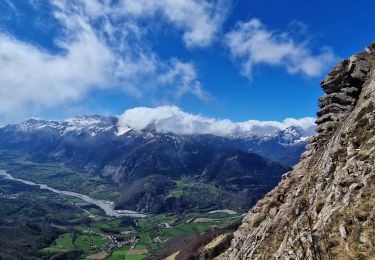
Trail Walking of 20 km to be discovered at Provence-Alpes-Côte d'Azur, Hautes-Alpes, Saint-Jacques-en-Valgodemard. This trail is proposed by tracegps.

Description

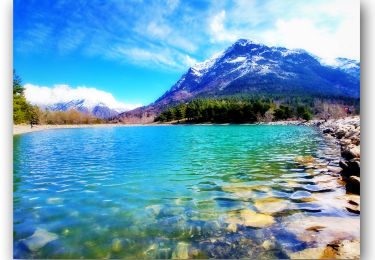
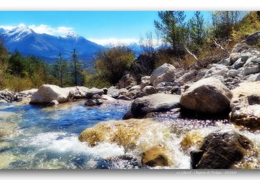
Première étape du Gite d’étape « Les Paris » au Gite du Casset. Nous vous proposons un itinéraire préservé et varié, reliant la vallée du Valgaudemar aux paysages de bocage de montagne du Champsaur. Au cœur du Parc National des Ecrins, vous découvrirez la richesse de la faune et de la flore, chamois, marmottes, aigles, lys orangés... Vous serez accueillis en gîte d'étape et en refuge où vous trouverez confort, authenticité, convivialité. Renseignements et réservations centralisés au 04 92 55 30 07 Le portage des sacs : Vos bagages peuvent être transportés dans la journée pour les retrouver le soir dans chaque gîte (sauf refuge). Possibilité de circuit avec un accompagnateur. Possibilité de portage des bagages avec des ânes.

Elevation profile

Photos

Positioning

Country:
France
Region :
Provence-Alpes-Côte d'Azur
Department/Province :
Hautes-Alpes
Municipality :
Saint-Jacques-en-Valgodemard
Location:
Unknown
Start:(UTM)
265098 ; 4961214 (32T) N.

Comments

Please log in to post a review or rate the element


Débutant mais je l'ai fais avec sac de 20kilos ;) Hard quand même.


Trails nearby

Trail Walking Aspres-lès-Corps - Aspres les corps - Roche Courbe - Photo
Walking
GUIDE
R@ph

Walking

Very difficult
(1)
Aspres-lès-Corps, Provence-Alpes-Côte d'Azur, Hautes-Alpes, France
10.6 km | 24 km-effort
4h 53min
Yes
Trail Walking Saint-Firmin - YHH081 Vallon de Prentiq - Photo
Walking
yveshumbert

Walking

Very easy
(1)
Saint-Firmin, Provence-Alpes-Côte d'Azur, Hautes-Alpes, France
6.7 km | 11.1 km-effort
2h 30min
Yes
Trail Touring skiing Aspres-lès-Corps - tentative du Laton, pic gazonné  - Photo
Touring skiing
nadd73

Touring skiing

Easy
Aspres-lès-Corps, Provence-Alpes-Côte d'Azur, Hautes-Alpes, France
6.9 km | 15.9 km-effort
4h 36min
Yes
Trail Walking Aspres-lès-Corps - Roche Courbe en circuit - Photo
Walking
Emelle

Walking

Medium
Aspres-lès-Corps, Provence-Alpes-Côte d'Azur, Hautes-Alpes, France
9.9 km | 23 km-effort
5h 57min
Yes
Trail Walking Saint-Firmin - Les pres hauts  6 kms - Photo
Walking
peillo

Walking

Saint-Firmin, Provence-Alpes-Côte d'Azur, Hautes-Alpes, France
5.2 km | 9.6 km-effort
1h 55min
Yes
Trail Walking Le Glaizil - 20190528_Chapeau de l'évêque via Le Glaizil - Photo
Walking
PapouBertrand

Walking

Medium
(1)
Le Glaizil, Provence-Alpes-Côte d'Azur, Hautes-Alpes, France
10.8 km | 20 km-effort
4h 46min
Yes
Trail Walking Saint-Jacques-en-Valgodemard - 20190409_Lac de Roaffan - Photo
Walking
PapouBertrand

Walking

Easy
Saint-Jacques-en-Valgodemard, Provence-Alpes-Côte d'Azur, Hautes-Alpes, France
12.3 km | 18 km-effort
5h 47min
Yes
Trail Walking Le Glaizil - Chapeau de l'évêque via le Glaizil - Photo
Walking
PapouBertrand

Walking

Very difficult
Le Glaizil, Provence-Alpes-Côte d'Azur, Hautes-Alpes, France
10.3 km | 19.8 km-effort
3h 56min
Yes
Trail Walking Aspres-lès-Corps - Le Grand Journal - Jonquilles  - Photo
Walking
PapouBertrand

Walking

Very difficult
Aspres-lès-Corps, Provence-Alpes-Côte d'Azur, Hautes-Alpes, France
9.6 km | 22 km-effort
5h 19min
Yes


Close
My subscriptions