Trail Walking Antony - Le ru des Godets et le ru d'Aulnay - Photo

Le ru des Godets et le ru d'Aulnay

 tracegps
tracegps

User

© OpenStreetMap contributors
Length
Length
25 km
Max alt
Max alt
177 m
Uphill gradient
Uphill gradient
375 m
Km-Effort
Km-Effort  
30 km
Min alt
Min alt
50 m
Downhill gradient
Downhill gradient
376 m
Boucle
Boucle
Yes
Creation date :
2014-12-10 00:00:00.0
Updated on :
2014-12-10 00:00:00.0

(0 Reviews)

Walking
Walking
5h10
Difficulty : Difficult

Scan this QR Code to open this trail in the SityTrail application

FREE GPS app for hiking

Logo SityTrail SityTrail

IGN / Geographical institutes

Download SityTrail from the App Store Download SityTrail from Google Play

Logo SityTrail SityTrail World

The world is yours!

Download SityTrail from the App Store Download SityTrail from Google Play Download SityTrail on Huawei AppGallery

About

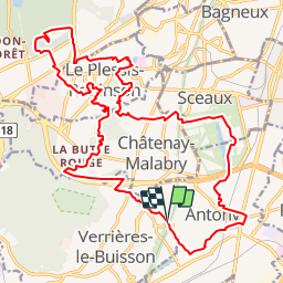
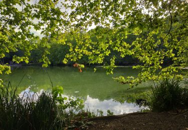
Trail Walking of 25 km to be discovered at Ile-de-France, Hauts-de-Seine, Antony. This trail is proposed by tracegps.

Description

Parking départ : Cimetière paysager de Clamart ou gare RER Antony. Descriptif : GRP, Cimetière de Clamart ... PR9, Bois de Meudon, carrefour de la Pierre aux Moines ... PR7, Bois de la Solitude et bois de la Garenne ... nb, Etang Colbert ... PR5, Parc Henri Sellier, terrasse ... PR7, Vallée aux Loups ... GRP, Parc de Sceaux, Château, bassin de l'Octogone ... nb, porte dela Grenouillère ... PR7, gare Parc d'Antony ... nb, le Pont d'Antony ... GR11, Parc Heller, PR6, Ru des Godets, Bois de Verrières ... nb, Butte Rouge ... PR7, Vallée aux Loups ... GRP le Plessis-Robinson Cité Jardin, Coeur de Ville, Cimetière de Clamart. Des sentiers ont pu être modifiés depuis la dernière validation et les itinéraires proposés n’engagent pas la responsabilité du Comité. Signalez-nous les modifications rencontrées pour mise à jour de la randothèque.

Elevation profile

Photos

Positioning

Country:
France
Region :
Ile-de-France
Department/Province :
Hauts-de-Seine
Municipality :
Antony
Location:
Unknown
Start:(UTM)
447219 ; 5400118 (31U) N.

Trails nearby

Trail Walking Bièvres - De Bièvres à Antony - Photo
Walking
tracegps

Walking

Medium
(1)
Bièvres, Ile-de-France, Essonne, France
11.9 km | 14 km-effort
3h 0min
No
Trail Walking Verrières-le-Buisson - Sur les sentiers de découverte du Bois de Verrières - Photo
Walking
tracegps

Walking

Medium
(2)
Verrières-le-Buisson, Ile-de-France, Essonne, France
22 km | 27 km-effort
4h 40min
Yes
Trail Walking Sceaux - Les Hauts de Bièvre - Photo
Walking
tracegps

Walking

Difficult
(2)
Sceaux, Ile-de-France, Hauts-de-Seine, France
25 km | 30 km-effort
6h 0min
Yes
Trail Walking Bièvres - Autour de Bièvres - Photo
Walking
tracegps

Walking

Medium
(4)
Bièvres, Ile-de-France, Essonne, France
7.6 km | 9.4 km-effort
2h 30min
Yes
Trail Walking Fontenay-aux-Roses -  Rando des 3 Parcs ! (des Gares RER) - Photo
Walking
dmj41

Walking

Very difficult
(2)
Fontenay-aux-Roses, Ile-de-France, Hauts-de-Seine, France
15.9 km | 19.5 km-effort
4h 26min
No
Trail On foot Villebon-sur-Yvette - Grand Tour de Villebon - Photo
On foot
PRO

On foot

Easy
(1)
Villebon-sur-Yvette, Ile-de-France, Essonne, France
13.1 km | 15.6 km-effort
3h 32min
Yes
Trail On foot Palaiseau - PR 11 - Photo
On foot
PRO

On foot

Easy
Palaiseau, Ile-de-France, Essonne, France
11.7 km | 14 km-effort
3h 10min
No
Trail On foot Antony - Sur la Rive Gauche de la Bièvre - Photo
On foot
PRO

On foot

Easy
Antony, Ile-de-France, Hauts-de-Seine, France
5 km | 6.2 km-effort
1h 24min
No
Trail Walking Clamart - Tour des etangs - Bois de Clamart et de Meudon - Photo
Walking
GUIDE
affinetataille

Walking

Easy
Clamart, Ile-de-France, Hauts-de-Seine, France
8 km | 9.9 km-effort
2h 16min
Yes


Close
My subscriptions