Trail Mountain bike Sérignac-sur-Garonne - Sérignac-sur-Garonne, promenade entre Canal et Garonne - Pays de l'Agenais - Photo

Sérignac-sur-Garonne, promenade entre Canal et Garonne - Pays de l'Agenais

 tracegps
tracegps

User

© OpenStreetMap contributors
Length
Length
12.3 km
Max alt
Max alt
53 m
Uphill gradient
Uphill gradient
90 m
Km-Effort
Km-Effort  
13.5 km
Min alt
Min alt
34 m
Downhill gradient
Downhill gradient
89 m
Boucle
Boucle
Yes
Creation date :
2014-12-10 00:00:00.0
Updated on :
2014-12-10 00:00:00.0

(0 Reviews)

Mountain bike
Mountain bike
1h30
Difficulty : Medium

Scan this QR Code to open this trail in the SityTrail application

FREE GPS app for hiking

Logo SityTrail SityTrail

IGN / Geographical institutes

Download SityTrail from the App Store Download SityTrail from Google Play

Logo SityTrail SityTrail World

The world is yours!

Download SityTrail from the App Store Download SityTrail from Google Play Download SityTrail on Huawei AppGallery

About

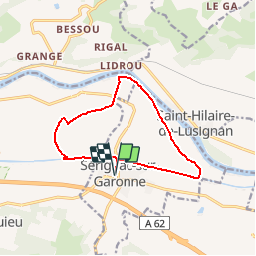
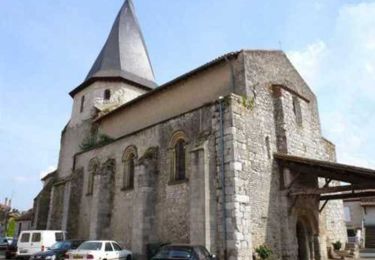
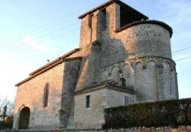
Trail Mountain bike of 12.3 km to be discovered at New Aquitaine, Lot-et-Garonne, Sérignac-sur-Garonne. This trail is proposed by tracegps.

Description

Sérignac sur Garonne C. de C. du Canton de Laplume en Bruilhois. Parcours sans difficulté majeure dans une plaine où vergers et peupleraies cohabitent, entre le canal de Garonne et son fleuve. Le long du canal, vous emprunterez la voie verte, nouvellement aménagée. Téléchargez la fiche de cette randonnée sur le site du Tourisme du Lot et Garonne.

Elevation profile

Photos

Positioning

Country:
France
Region :
New Aquitaine
Department/Province :
Lot-et-Garonne
Municipality :
Sérignac-sur-Garonne
Location:
Unknown
Start:(UTM)
299032 ; 4898716 (31T) N.

Trails nearby

Trail On foot Montesquieu - Montesquieu, la randonnée du pont de Ninon - 4.8 km - Photo
On foot
PRO

On foot

Easy
Montesquieu, New Aquitaine, Lot-et-Garonne, France
4.7 km | 6.3 km-effort
1h 26min
Yes
Trail On foot Montesquieu - Sur les terres de Montesquieu, entre Garonne et vergers - 6 km - Photo
On foot
PRO

On foot

Easy
Montesquieu, New Aquitaine, Lot-et-Garonne, France
3.5 km | 3.8 km-effort
51min
No
Trail Walking Montesquieu - Sur les terres de Montesquieu, entre Garonne et vergers - Pays d'Albret - Photo
Walking
tracegps

Walking

Easy
Montesquieu, New Aquitaine, Lot-et-Garonne, France
5.9 km | 6.4 km-effort
1h 30min
Yes
Trail Equestrian Clermont-Dessous - Saint-Médard, vues sur la Garonne et sa vallée - Pays de la vallée du Lot - Photo
Equestrian
tracegps

Equestrian

Medium
Clermont-Dessous, New Aquitaine, Lot-et-Garonne, France
10.9 km | 15.6 km-effort
1h 49min
Yes
Trail Mountain bike Clermont-Dessous - Saint-Médard, vues sur la Garonne et sa vallée - Pays de la vallée du Lot - Photo
Mountain bike
tracegps

Mountain bike

Medium
Clermont-Dessous, New Aquitaine, Lot-et-Garonne, France
10.9 km | 15.6 km-effort
1h 19min
Yes
Trail Walking Clermont-Dessous - Saint-Médard, vues sur la Garonne et sa vallée - Pays de la vallée du Lot - Photo
Walking
tracegps

Walking

Medium
Clermont-Dessous, New Aquitaine, Lot-et-Garonne, France
10.9 km | 15.6 km-effort
3h 0min
Yes
Trail Walking Sérignac-sur-Garonne - Sérignac-sur-Garonne, promenade entre Canal et Garonne - Pays de l'Agenais - Photo
Walking
tracegps

Walking

Medium
Sérignac-sur-Garonne, New Aquitaine, Lot-et-Garonne, France
12.3 km | 13.5 km-effort
3h 15min
Yes
Trail Walking Saint-Hilaire-de-Lusignan - Lusignan-Grand, site panoramique de la vallée de la Garonne - Pays de l'Agenais - Photo
Walking
tracegps

Walking

Easy
Saint-Hilaire-de-Lusignan, New Aquitaine, Lot-et-Garonne, France
4.6 km | 7.1 km-effort
1h 30min
Yes
Trail Walking Sainte-Colombe-en-Bruilhois - de Sainte Colombe à Roquefort  - Photo
Walking
mdns

Walking

Medium
Sainte-Colombe-en-Bruilhois, New Aquitaine, Lot-et-Garonne, France
6.2 km | 8.2 km-effort
2h 46min
No


Close
My subscriptions