Trail Equestrian Birac-sur-Trec - Birac-sur-Trec, des coteaux à la plaine de Garonne - Pays Val de Garonne - Gascogne - Photo

Birac-sur-Trec, des coteaux à la plaine de Garonne - Pays Val de Garonne - Gascogne

 tracegps
tracegps

User

© OpenStreetMap contributors
Length
Length
10.7 km
Max alt
Max alt
127 m
Uphill gradient
Uphill gradient
198 m
Km-Effort
Km-Effort  
13.3 km
Min alt
Min alt
33 m
Downhill gradient
Downhill gradient
198 m
Boucle
Boucle
Yes
Creation date :
2014-12-10 00:00:00.0
Updated on :
2014-12-10 00:00:00.0

(0 Reviews)

Equestrian
Equestrian
2h00
Difficulty : Medium

Scan this QR Code to open this trail in the SityTrail application

FREE GPS app for hiking

Logo SityTrail SityTrail

IGN / Geographical institutes

Download SityTrail from the App Store Download SityTrail from Google Play

Logo SityTrail SityTrail World

The world is yours!

Download SityTrail from the App Store Download SityTrail from Google Play Download SityTrail on Huawei AppGallery

About

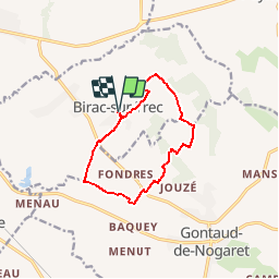
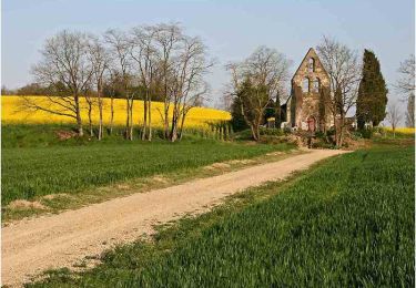
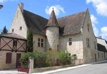
Trail Equestrian of 10.7 km to be discovered at New Aquitaine, Lot-et-Garonne, Birac-sur-Trec. This trail is proposed by tracegps.

Description

Birac sur Trec Communauté de Communes Val de Garonne. Du village de Birac, implanté dans les premiers contreforts des coteaux du marmandais, cette boucle culmine à 130 m, avant de redescendre sur les pistes sableuses de la vallée de la Garonne. Téléchargez la fiche de cette randonnée sur le site du Tourisme du Lot et Garonne.

Elevation profile

Photos

Positioning

Country:
France
Region :
New Aquitaine
Department/Province :
Lot-et-Garonne
Municipality :
Birac-sur-Trec
Location:
Unknown
Start:(UTM)
282574 ; 4929468 (31T) N.

Trails nearby

Trail Mountain bike Virazeil - Randonnée escassefort - Photo
Mountain bike
fred47

Mountain bike

Medium
Virazeil, New Aquitaine, Lot-et-Garonne, France
18.5 km | 23 km-effort
1h 35min
Yes
Trail Walking Virazeil - Virazeil 2 - Photo
Walking
fred47

Walking

Easy
Virazeil, New Aquitaine, Lot-et-Garonne, France
3.6 km | 4.6 km-effort
51min
Yes
Trail Equestrian Gontaud-de-Nogaret - Bistauzac, une succession de points de vue - Pays Val de Garonne - Gascogne - Photo
Equestrian
tracegps

Equestrian

Medium
Gontaud-de-Nogaret, New Aquitaine, Lot-et-Garonne, France
12.7 km | 15.8 km-effort
2h 15min
Yes
Trail Mountain bike Gontaud-de-Nogaret - Bistauzac, une succession de points de vue - Pays Val de Garonne - Gascogne - Photo
Mountain bike
tracegps

Mountain bike

Medium
(1)
Gontaud-de-Nogaret, New Aquitaine, Lot-et-Garonne, France
12.7 km | 15.8 km-effort
1h 45min
Yes
Trail Walking Gontaud-de-Nogaret - Bistauzac, une succession de points de vue - Pays Val de Garonne - Gascogne - Photo
Walking
tracegps

Walking

Medium
Gontaud-de-Nogaret, New Aquitaine, Lot-et-Garonne, France
12.7 km | 15.8 km-effort
3h 19min
Yes
Trail Equestrian Gontaud-de-Nogaret - Gontaud-de-Nogaret, la balade du Moulin de Gibra - Pays Val de Garonne - Gascogne - Photo
Equestrian
tracegps

Equestrian

Medium
Gontaud-de-Nogaret, New Aquitaine, Lot-et-Garonne, France
8 km | 10.5 km-effort
1h 19min
Yes
Trail Mountain bike Gontaud-de-Nogaret - Gontaud-de-Nogaret, la balade du Moulin de Gibra - Pays Val de Garonne - Gascogne - Photo
Mountain bike
tracegps

Mountain bike

Medium
Gontaud-de-Nogaret, New Aquitaine, Lot-et-Garonne, France
8 km | 10.5 km-effort
1h 0min
Yes
Trail Walking Gontaud-de-Nogaret - Gontaud-de-Nogaret, la balade du Moulin de Gibra - Pays Val de Garonne - Gascogne - Photo
Walking
tracegps

Walking

Medium
Gontaud-de-Nogaret, New Aquitaine, Lot-et-Garonne, France
8 km | 10.5 km-effort
2h 34min
Yes
Trail Mountain bike Birac-sur-Trec - Birac-sur-Trec, des coteaux à la plaine de Garonne - Pays Val de Garonne - Gascogne - Photo
Mountain bike
tracegps

Mountain bike

Medium
Birac-sur-Trec, New Aquitaine, Lot-et-Garonne, France
10.7 km | 13.3 km-effort
1h 30min
Yes


Close
My subscriptions