Trail Walking Casteljaloux - Casteljaloux, porte de la forêt landaise - Pays Val de Garonne - Gascogne - Photo

Casteljaloux, porte de la forêt landaise - Pays Val de Garonne - Gascogne

 tracegps
tracegps

User

© OpenStreetMap contributors
Length
Length
9.2 km
Max alt
Max alt
123 m
Uphill gradient
Uphill gradient
143 m
Km-Effort
Km-Effort  
11.1 km
Min alt
Min alt
66 m
Downhill gradient
Downhill gradient
143 m
Boucle
Boucle
Yes
Creation date :
2014-12-10 00:00:00.0
Updated on :
2014-12-10 00:00:00.0

(0 Reviews)

Walking
Walking
3h00
Difficulty : Medium

Scan this QR Code to open this trail in the SityTrail application

FREE GPS app for hiking

Logo SityTrail SityTrail

IGN / Geographical institutes

Download SityTrail from the App Store Download SityTrail from Google Play

Logo SityTrail SityTrail World

The world is yours!

Download SityTrail from the App Store Download SityTrail from Google Play Download SityTrail on Huawei AppGallery

About

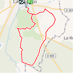
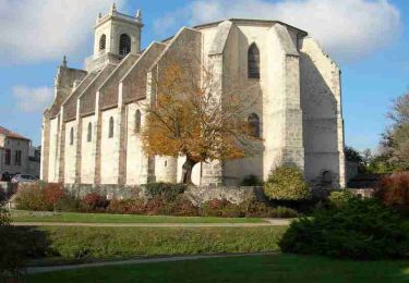
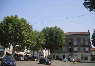
Trail Walking of 9.2 km to be discovered at New Aquitaine, Lot-et-Garonne, Casteljaloux. This trail is proposed by tracegps.

Description

Casteljaloux / le Lanin Cté Com. Coteaux et Landes de Gascogne. Cet itinéraire vous emmènera de la ville d’eau, sur les coteaux agricoles avant de s’enfoncer dans la forêt landaise, plantée principalement de pins et abritant quelques palombières. Téléchargez la fiche de cette randonnée sur le site du Tourisme du Lot et Garonne.

Elevation profile

Photos

Positioning

Country:
France
Region :
New Aquitaine
Department/Province :
Lot-et-Garonne
Municipality :
Casteljaloux
Location:
Unknown
Start:(UTM)
267828 ; 4910523 (31T) N.

Trails nearby

Trail On foot Labastide-Castel-Amouroux - Labastide-Castel-Amouroux vers l’Église de Saint-Gény - 5.1 km - Photo
On foot
PRO

On foot

Easy
Labastide-Castel-Amouroux, New Aquitaine, Lot-et-Garonne, France
4.6 km | 5.9 km-effort
1h 20min
Yes
Trail On foot Labastide-Castel-Amouroux - Labastide-Castel-Amouroux à ciel ouvert - 17.7 km - Photo
On foot
PRO

On foot

Medium
Labastide-Castel-Amouroux, New Aquitaine, Lot-et-Garonne, France
17.6 km | 22 km-effort
5h 3min
Yes
Trail On foot Pompogne - La Réunion - La Taillade, vacances dans les bois de la Réunion - 3.4 km - Photo
On foot
PRO

On foot

Easy
Pompogne, New Aquitaine, Lot-et-Garonne, France
3 km | 3.3 km-effort
45min
Yes
Trail On foot La Réunion - La Réunion - La Taillade, par les églises de Beyrac et Couthures - 21.3 km - Photo
On foot
PRO

On foot

Medium
La Réunion, New Aquitaine, Lot-et-Garonne, France
21 km | 25 km-effort
5h 46min
Yes
Trail Walking Beauziac - beauziac - Photo
Walking
christiane01

Walking

Easy
Beauziac, New Aquitaine, Lot-et-Garonne, France
6.7 km | 7.8 km-effort
2h 21min
Yes
Trail Cycle Casteljaloux - Circuit des Cadets de Gascogne - Casteljaloux - Photo
Cycle
tracegps

Cycle

Medium
Casteljaloux, New Aquitaine, Lot-et-Garonne, France
86 km | 103 km-effort
4h 30min
Yes
Trail Mountain bike Casteljaloux - Casteljaloux, porte de la forêt landaise - Pays Val de Garonne - Gascogne - Photo
Mountain bike
tracegps

Mountain bike

Medium
Casteljaloux, New Aquitaine, Lot-et-Garonne, France
9.2 km | 11.1 km-effort
1h 15min
Yes
Trail Mountain bike Casteljaloux - Casteljaloux, au pays des Cadets de Gascogne - Pays Val de Garonne - Gascogne - Photo
Mountain bike
tracegps

Mountain bike

Difficult
Casteljaloux, New Aquitaine, Lot-et-Garonne, France
17.5 km | 20 km-effort
2h 15min
Yes
Trail Walking Casteljaloux - Casteljaloux, au pays des Cadets de Gascogne - Pays Val de Garonne - Gascogne - Photo
Walking
tracegps

Walking

Difficult
(1)
Casteljaloux, New Aquitaine, Lot-et-Garonne, France
17.5 km | 20 km-effort
4h 30min
Yes


Close
My subscriptions