Trail Mountain bike Tonneins - Tonneins, Garonne d'hier et d'aujourd'hui - Pays Val de Garonne - Gascogne - Photo

Tonneins, Garonne d'hier et d'aujourd'hui - Pays Val de Garonne - Gascogne

 tracegps
tracegps

User

© OpenStreetMap contributors
Length
Length
13.7 km
Max alt
Max alt
181 m
Uphill gradient
Uphill gradient
240 m
Km-Effort
Km-Effort  
16.9 km
Min alt
Min alt
25 m
Downhill gradient
Downhill gradient
240 m
Boucle
Boucle
Yes
Creation date :
2014-12-10 00:00:00.0
Updated on :
2014-12-10 00:00:00.0

(0 Reviews)

Mountain bike
Mountain bike
1h45
Difficulty : Difficult

Scan this QR Code to open this trail in the SityTrail application

FREE GPS app for hiking

Logo SityTrail SityTrail

IGN / Geographical institutes

Download SityTrail from the App Store Download SityTrail from Google Play

Logo SityTrail SityTrail World

The world is yours!

Download SityTrail from the App Store Download SityTrail from Google Play Download SityTrail on Huawei AppGallery

About

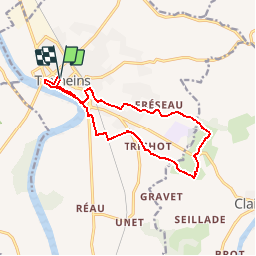
Trail Mountain bike of 13.7 km to be discovered at New Aquitaine, Lot-et-Garonne, Tonneins. This trail is proposed by tracegps.

Description

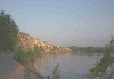
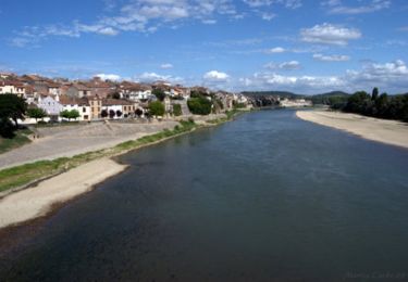
Tonneins -Communauté de Communes Val de Garonne. Les passerelles et berges de Garonne ne sont pas accessibles aux cavaliers. Ce circuit semi-urbain domine la Garonne dans sa première partie, avant d’escalader la colline d’où s’ouvrent de vastes panoramas sur les vallées de la Garonne et du Lot et sur les coteaux du Marmandais et du Pays de Serres. Soyez très vigilants lors du franchissement des D 911 et D 813. Téléchargez la fiche de cette randonnée sur le site du Tourisme du Lot et Garonne.

Elevation profile

Photos

Positioning

Country:
France
Region :
New Aquitaine
Department/Province :
Lot-et-Garonne
Municipality :
Tonneins
Location:
Unknown
Start:(UTM)
285643 ; 4918804 (31T) N.

Trails nearby

Trail Walking Tonneins - Unet, petite randonnée entre Garonne et Lot - Pays Val de Garonne - Gascogne - Photo
Walking
tracegps

Walking

Medium
(1)
Tonneins, New Aquitaine, Lot-et-Garonne, France
5.6 km | 7.8 km-effort
2h 0min
Yes
Trail On foot Lagruère - Lagruère, dans la boucle de l'Ourbise - 10.6 km - Photo
On foot
PRO

On foot

Easy
Lagruère, New Aquitaine, Lot-et-Garonne, France
10.5 km | 11.6 km-effort
2h 37min
Yes
Trail On foot Calonges - Calonges, balade dans la plaine de la Garonne - 11.8 km - Photo
On foot
PRO

On foot

Easy
Calonges, New Aquitaine, Lot-et-Garonne, France
4.2 km | 4.6 km-effort
1h 3min
No
Trail On foot Lagruère - Lagruère, promenade sur les berges de Garonne - 9.8 km - Photo
On foot
PRO

On foot

Easy
Lagruère, New Aquitaine, Lot-et-Garonne, France
9.7 km | 10.9 km-effort
2h 28min
Yes
Trail Walking Tonneins - Tonneins - Photo
Walking
Briarwood

Walking

Very easy
Tonneins, New Aquitaine, Lot-et-Garonne, France
5.8 km | 6.5 km-effort
1h 39min
Yes
Trail Walking Tonneins - Tonneins, Garonne d'hier et d'aujourd'hui - Pays Val de Garonne - Gascogne - Photo
Walking
tracegps

Walking

Difficult
Tonneins, New Aquitaine, Lot-et-Garonne, France
13.7 km | 16.9 km-effort
3h 34min
Yes
Trail Mountain bike Tonneins - Unet, petite randonnée entre Garonne et Lot - Pays Val de Garonne - Gascogne - Photo
Mountain bike
tracegps

Mountain bike

Medium
Tonneins, New Aquitaine, Lot-et-Garonne, France
5.6 km | 7.8 km-effort
45min
Yes
Trail Mountain bike Lagruère - Lagruère, promenade sur les berges de Garonne - Pays Val de Garonne - Gascogne - Photo
Mountain bike
tracegps

Mountain bike

Medium
Lagruère, New Aquitaine, Lot-et-Garonne, France
9.7 km | 10.8 km-effort
1h 15min
Yes
Trail Walking Lagruère - Lagruère, promenade sur les berges de Garonne - Pays Val de Garonne - Gascogne - Photo
Walking
tracegps

Walking

Medium
Lagruère, New Aquitaine, Lot-et-Garonne, France
9.7 km | 10.8 km-effort
2h 30min
Yes


Close
My subscriptions