Trail Walking Dolmayrac - Dolmayrac, cité promontoire sur la vallée du Lot - Pays de la vallée du Lot - Photo

Dolmayrac, cité promontoire sur la vallée du Lot - Pays de la vallée du Lot

 tracegps
tracegps

User

© OpenStreetMap contributors
Length
Length
12.7 km
Max alt
Max alt
204 m
Uphill gradient
Uphill gradient
397 m
Km-Effort
Km-Effort  
18 km
Min alt
Min alt
86 m
Downhill gradient
Downhill gradient
387 m
Boucle
Boucle
Yes
Creation date :
2014-12-10 00:00:00.0
Updated on :
2014-12-10 00:00:00.0

(0 Reviews)

Walking
Walking
3h30
Difficulty : Difficult

Scan this QR Code to open this trail in the SityTrail application

FREE GPS app for hiking

Logo SityTrail SityTrail

IGN / Geographical institutes

Download SityTrail from the App Store Download SityTrail from Google Play

Logo SityTrail SityTrail World

The world is yours!

Download SityTrail from the App Store Download SityTrail from Google Play Download SityTrail on Huawei AppGallery

About

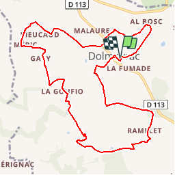
Trail Walking of 12.7 km to be discovered at New Aquitaine, Lot-et-Garonne, Dolmayrac. This trail is proposed by tracegps.

Description

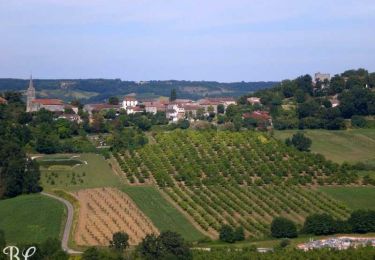
Dolmayrac / Saint Cyprien Cté de Communes du Villeneuvois. Montées et descentes très accentuées se succèdent sur ce circuit offrant au nord de vastes panoramas sur la vallée du Lot et au sud des points de vue sur les pechs environnants du Pays de Serres. Téléchargez la fiche de cette randonnée sur le site du Tourisme du Lot et Garonne.

Elevation profile

Photos

Positioning

Country:
France
Region :
New Aquitaine
Department/Province :
Lot-et-Garonne
Municipality :
Dolmayrac
Location:
Unknown
Start:(UTM)
308068 ; 4914900 (31T) N.

Trails nearby

Trail Mountain bike Dolmayrac - Dolmayrac / Laugnac, une grande randonnée dans les Serres - Photo
Mountain bike
tracegps

Mountain bike

Difficult
Dolmayrac, New Aquitaine, Lot-et-Garonne, France
27 km | 35 km-effort
3h 34min
Yes
Trail Walking Dolmayrac - Dolmayrac / Laugnac, une grande randonnée dans les Serres - Photo
Walking
tracegps

Walking

Difficult
Dolmayrac, New Aquitaine, Lot-et-Garonne, France
27 km | 35 km-effort
7h 15min
Yes
Trail Walking Sembas - Lancenne  Sembzs - Photo
Walking
mdns

Walking

Very easy
Sembas, New Aquitaine, Lot-et-Garonne, France
8.1 km | 9.5 km-effort
2h 27min
Yes
Trail Cycle Sainte-Livrade-sur-Lot - Circuit de Sainte Livrade sur Lot - Vignes et vergers - Photo
Cycle
tracegps

Cycle

Easy
Sainte-Livrade-sur-Lot, New Aquitaine, Lot-et-Garonne, France
15.7 km | 16.9 km-effort
45min
Yes
Trail Cycle Allez-et-Cazeneuve - Circuit Haut Tour des Grottes en cyclo - Photo
Cycle
tracegps

Cycle

Medium
Allez-et-Cazeneuve, New Aquitaine, Lot-et-Garonne, France
25 km | 31 km-effort
1h 15min
Yes
Trail Mountain bike Dolmayrac - Dolmayrac / Laugnac, une grande randonnée dans les Serres - Pays de la vallée du Lot - Photo
Mountain bike
tracegps

Mountain bike

Difficult
Dolmayrac, New Aquitaine, Lot-et-Garonne, France
27 km | 35 km-effort
3h 34min
Yes
Trail Walking Dolmayrac - Dolmayrac / Laugnac, une grande randonnée dans les Serres - Pays de la vallée du Lot - Photo
Walking
tracegps

Walking

Very difficult
Dolmayrac, New Aquitaine, Lot-et-Garonne, France
27 km | 35 km-effort
7h 15min
Yes
Trail Equestrian Dolmayrac - Dolmayrac, cité promontoire sur la vallée du Lot - Pays de la vallée du Lot - Photo
Equestrian
tracegps

Equestrian

Difficult
Dolmayrac, New Aquitaine, Lot-et-Garonne, France
12.7 km | 18 km-effort
2h 15min
Yes
Trail Mountain bike Dolmayrac - Dolmayrac, cité promontoire sur la vallée du Lot - Pays de la vallée du Lot - Photo
Mountain bike
tracegps

Mountain bike

Difficult
Dolmayrac, New Aquitaine, Lot-et-Garonne, France
12.7 km | 18 km-effort
1h 40min
Yes


Close
My subscriptions