Trail Walking Lévignac-de-Guyenne - Lévignac, une grande randonnée en Guyenne - Pays du Dropt - Photo

Lévignac, une grande randonnée en Guyenne - Pays du Dropt

 tracegps
tracegps

User

© OpenStreetMap contributors
Length
Length
18.2 km
Max alt
Max alt
130 m
Uphill gradient
Uphill gradient
259 m
Km-Effort
Km-Effort  
22 km
Min alt
Min alt
32 m
Downhill gradient
Downhill gradient
259 m
Boucle
Boucle
Yes
Creation date :
2014-12-10 00:00:00.0
Updated on :
2014-12-10 00:00:00.0

(0 Reviews)

Walking
Walking
4h45
Difficulty : Difficult

Scan this QR Code to open this trail in the SityTrail application

FREE GPS app for hiking

Logo SityTrail SityTrail

IGN / Geographical institutes

Download SityTrail from the App Store Download SityTrail from Google Play

Logo SityTrail SityTrail World

The world is yours!

Download SityTrail from the App Store Download SityTrail from Google Play Download SityTrail on Huawei AppGallery

About

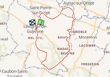
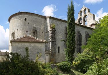
Trail Walking of 18.2 km to be discovered at New Aquitaine, Lot-et-Garonne, Lévignac-de-Guyenne. This trail is proposed by tracegps.

Description

Lévignac de G. / St Pierre / Ste Croix C. C. du Pays de Duras. En toponymie, Lévignac, ancienne bastide anglaise dont il reste peu de vestiges, signifie le pays de la vigne. La commune a vu peu à peu disparaître cette production au profit des vergers de pruniers d’Ente. Téléchargez la fiche de cette randonnée sur le site du Tourisme du Lot et Garonne.

Elevation profile

Photos

Positioning

Country:
France
Region :
New Aquitaine
Department/Province :
Lot-et-Garonne
Municipality :
Lévignac-de-Guyenne
Location:
Unknown
Start:(UTM)
277861 ; 4945491 (31T) N.

Trails nearby

Trail Walking Lévignac-de-Guyenne - A travers les champs et vergers au sud de Lévignac De Guyenne - Photo
Walking
Xavier Jaspar

Walking

Easy
Lévignac-de-Guyenne, New Aquitaine, Lot-et-Garonne, France
6.7 km | 8.4 km-effort
1h 30min
Yes
Trail Equestrian Monteton - Monteton, randonnée vers les bois de Chavaneau - Photo
Equestrian
tracegps

Equestrian

Difficult
Monteton, New Aquitaine, Lot-et-Garonne, France
19.5 km | 24 km-effort
3h 19min
Yes
Trail Mountain bike Monteton - Monteton, randonnée vers les bois de Chavaneau - Photo
Mountain bike
tracegps

Mountain bike

Medium
Monteton, New Aquitaine, Lot-et-Garonne, France
19.5 km | 24 km-effort
2h 2min
Yes
Trail Walking Monteton - Monteton, randonnée vers les bois de Chavaneau - Photo
Walking
tracegps

Walking

Difficult
Monteton, New Aquitaine, Lot-et-Garonne, France
19.5 km | 24 km-effort
5h 0min
Yes
Trail Equestrian Saint-Géraud - Circuit panoramique sur la vallée du Drop - Saint-Géraud - Photo
Equestrian
tracegps

Equestrian

Medium
Saint-Géraud, New Aquitaine, Lot-et-Garonne, France
10.1 km | 12.4 km-effort
1h 45min
Yes
Trail Mountain bike Saint-Géraud - Circuit panoramique sur la vallée du Drop - Saint-Géraud - Photo
Mountain bike
tracegps

Mountain bike

Easy
Saint-Géraud, New Aquitaine, Lot-et-Garonne, France
10.1 km | 12.4 km-effort
1h 19min
Yes
Trail Walking Saint-Géraud - Circuit panoramique sur la vallée du Drop - Saint-Géraud - Photo
Walking
tracegps

Walking

Medium
Saint-Géraud, New Aquitaine, Lot-et-Garonne, France
10.1 km | 12.4 km-effort
2h 30min
Yes
Trail Mountain bike Monteton - Monteton, le point de vue des 13 clochers - Pays du Dropt - Photo
Mountain bike
tracegps

Mountain bike

Easy
(1)
Monteton, New Aquitaine, Lot-et-Garonne, France
6.2 km | 7.5 km-effort
1h 10min
Yes
Trail Walking Monteton - Monteton, le point de vue des 13 clochers - Pays du Dropt - Photo
Walking
tracegps

Walking

Easy
(2)
Monteton, New Aquitaine, Lot-et-Garonne, France
6.2 km | 7.5 km-effort
2h 10min
Yes


Close
My subscriptions