Trail Walking Saint-Sernin - Lubersac, une église de Saint-Sernin de Duras - Pays du Dropt - Photo

Lubersac, une église de Saint-Sernin de Duras - Pays du Dropt

 tracegps
tracegps

User

© OpenStreetMap contributors
Length
Length
5.4 km
Max alt
Max alt
86 m
Uphill gradient
Uphill gradient
74 m
Km-Effort
Km-Effort  
6.4 km
Min alt
Min alt
43 m
Downhill gradient
Downhill gradient
74 m
Boucle
Boucle
Yes
Creation date :
2014-12-10 00:00:00.0
Updated on :
2014-12-10 00:00:00.0

(0 Reviews)

Walking
Walking
2h00
Difficulty : Easy

Scan this QR Code to open this trail in the SityTrail application

FREE GPS app for hiking

Logo SityTrail SityTrail

IGN / Geographical institutes

Download SityTrail from the App Store Download SityTrail from Google Play

Logo SityTrail SityTrail World

The world is yours!

Download SityTrail from the App Store Download SityTrail from Google Play Download SityTrail on Huawei AppGallery

About

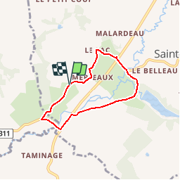
Trail Walking of 5.4 km to be discovered at New Aquitaine, Lot-et-Garonne, Saint-Sernin. This trail is proposed by tracegps.

Description

Lubersac commune de Saint Sernin de Duras C. C. Pays de Duras. Dans ce hameau traversé par une ancienne voie romaine, vous franchirez par deux fois et longerez sur quelques dizaines de mètres la départementale 708. Une grande vigilance est alors recommandée. Téléchargez la fiche de cette randonnée sur le site du Tourisme du Lot et Garonne.

Elevation profile

Photos

Positioning

Country:
France
Region :
New Aquitaine
Department/Province :
Lot-et-Garonne
Municipality :
Saint-Sernin
Location:
Unknown
Start:(UTM)
279066 ; 4954036 (31T) N.

Trails nearby

Trail Walking Pardaillan - Saint Front - pardaillan - Photo
Walking
Briarwood

Walking

Easy
(1)
Pardaillan, New Aquitaine, Lot-et-Garonne, France
6 km | 6.9 km-effort
1h 47min
Yes
Trail Walking Baleyssagues - Balayssagues - Photo
Walking
Briarwood

Walking

Easy
Baleyssagues, New Aquitaine, Lot-et-Garonne, France
5.3 km | 6.4 km-effort
1h 34min
Yes
Trail Walking Villeneuve-de-Duras - Villeneuve de D. - Photo
Walking
amelie14

Walking

Easy
(1)
Villeneuve-de-Duras, New Aquitaine, Lot-et-Garonne, France
16.5 km | 19.4 km-effort
3h 25min
Yes
Trail Equestrian Villeneuve-de-Duras - Saint-Léger, entre bois, vignes et vergers de pruniers - Photo
Equestrian
tracegps

Equestrian

Easy
Villeneuve-de-Duras, New Aquitaine, Lot-et-Garonne, France
10.4 km | 12.3 km-effort
1h 45min
Yes
Trail Mountain bike Villeneuve-de-Duras - Saint-Léger, entre bois, vignes et vergers de pruniers - Photo
Mountain bike
tracegps

Mountain bike

Easy
Villeneuve-de-Duras, New Aquitaine, Lot-et-Garonne, France
10.4 km | 12.3 km-effort
1h 15min
Yes
Trail Walking Villeneuve-de-Duras - Saint-Léger, entre bois, vignes et vergers de pruniers - Photo
Walking
tracegps

Walking

Medium
Villeneuve-de-Duras, New Aquitaine, Lot-et-Garonne, France
10.4 km | 12.3 km-effort
2h 40min
Yes
Trail Walking Villeneuve-de-Duras - Saint leger - Photo
Walking
Briarwood

Walking

Medium
Villeneuve-de-Duras, New Aquitaine, Lot-et-Garonne, France
10.4 km | 12.2 km-effort
2h 29min
Yes
Trail Walking Saint-Sernin - Lubersac - Photo
Walking
Briarwood

Walking

Easy
Saint-Sernin, New Aquitaine, Lot-et-Garonne, France
5.9 km | 7.3 km-effort
1h 50min
Yes
Trail Mountain bike Duras - Ronde du Pruneau - Duras - Photo
Mountain bike
tracegps

Mountain bike

Difficult
Duras, New Aquitaine, Lot-et-Garonne, France
42 km | 51 km-effort
3h 30min
Yes


Close
My subscriptions