Trail Walking Pujols - Nouaillac, randonnée bucolique dans le Villeneuvois - Pays de la vallée du Lot - Photo

Nouaillac, randonnée bucolique dans le Villeneuvois - Pays de la vallée du Lot

 tracegps
tracegps

User

© OpenStreetMap contributors
Length
Length
10.9 km
Max alt
Max alt
212 m
Uphill gradient
Uphill gradient
314 m
Km-Effort
Km-Effort  
15 km
Min alt
Min alt
95 m
Downhill gradient
Downhill gradient
310 m
Boucle
Boucle
Yes
Creation date :
2014-12-10 00:00:00.0
Updated on :
2014-12-10 00:00:00.0

(1 Reviews)

Walking
Walking
3h00
Difficulty : Medium

Scan this QR Code to open this trail in the SityTrail application

FREE GPS app for hiking

Logo SityTrail SityTrail

IGN / Geographical institutes

Download SityTrail from the App Store Download SityTrail from Google Play

Logo SityTrail SityTrail World

The world is yours!

Download SityTrail from the App Store Download SityTrail from Google Play Download SityTrail on Huawei AppGallery

About

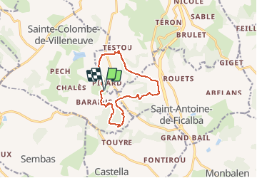
Trail Walking of 10.9 km to be discovered at New Aquitaine, Lot-et-Garonne, Pujols. This trail is proposed by tracegps.

Description

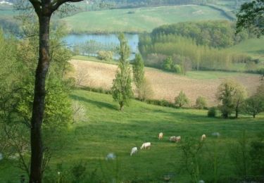
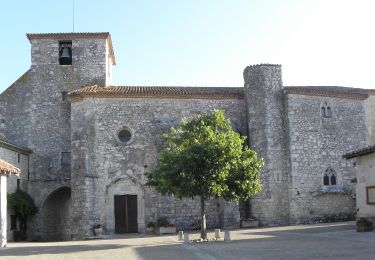
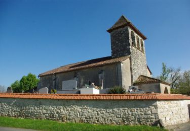
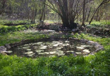
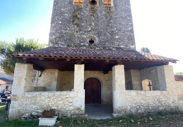
Nouaillac Commune de Pujols Cté de Communes du Villeneuvois. Une petite église, des pigeonniers, la traversée de la vallée de la Masse par deux fois, des plateaux boisés et des combes escarpées, parcourus par des chemins le plus souvent caillouteux, sont au programme de cette très sympathique randonnée bucolique… Téléchargez la fiche de cette randonnée sur le site du Tourisme du Lot et Garonne.

Elevation profile

Photos

Positioning

Country:
France
Region :
New Aquitaine
Department/Province :
Lot-et-Garonne
Municipality :
Pujols
Location:
Unknown
Start:(UTM)
315063 ; 4912395 (31T) N.

Comments

Please log in to post a review or rate the element


Génial


Trails nearby

Trail Walking Sainte-Colombe-de-Villeneuve - Sainte Colombe de Villeneuve, la balade du lac de Baniérettes - Pays de la vallée du Lot - Photo
Walking
tracegps

Walking

Medium
(4)
Sainte-Colombe-de-Villeneuve, New Aquitaine, Lot-et-Garonne, France
8.2 km | 10.5 km-effort
2h 0min
Yes
Trail Walking Pujols - Cambes, un circuit autour d'une combe boisée - Pays de la vallée du Lot - Photo
Walking
tracegps

Walking

Easy
(1)
Pujols, New Aquitaine, Lot-et-Garonne, France
4.2 km | 5.7 km-effort
1h 15min
Yes
Trail On foot Pujols - Pujols - Vallée de la Mail - 10.5 - Photo
On foot
PRO

On foot

Easy
Pujols, New Aquitaine, Lot-et-Garonne, France
7.3 km | 11.3 km-effort
2h 33min
Yes
Trail On foot Sainte-Colombe-de-Villeneuve - Sainte-Colombe-de-Villeneuve, vers les grottes de Lastournelles - 10.9 km - Photo
On foot
PRO

On foot

Easy
Sainte-Colombe-de-Villeneuve, New Aquitaine, Lot-et-Garonne, France
10.8 km | 14.5 km-effort
3h 17min
Yes
Trail Walking Sainte-Colombe-de-Villeneuve - Vers l'église du Laurier - Sainte Colombe de Villeneuve - Photo
Walking
tracegps

Walking

Medium
Sainte-Colombe-de-Villeneuve, New Aquitaine, Lot-et-Garonne, France
11.7 km | 15.8 km-effort
3h 0min
Yes
Trail Equestrian Castella - Vers la fontaine de Fonbourrugues - Castella - Photo
Equestrian
tracegps

Equestrian

Easy
Castella, New Aquitaine, Lot-et-Garonne, France
11.9 km | 15.6 km-effort
2h 0min
Yes
Trail Mountain bike Castella - Vers la fontaine de Fonbourrugues - Castella - Photo
Mountain bike
tracegps

Mountain bike

Easy
Castella, New Aquitaine, Lot-et-Garonne, France
11.9 km | 15.6 km-effort
1h 30min
Yes
Trail Walking Castella - Vers la fontaine de Fonbourrugues - Castella - Photo
Walking
tracegps

Walking

Medium
Castella, New Aquitaine, Lot-et-Garonne, France
11.9 km | 15.6 km-effort
3h 15min
Yes
Trail Walking Pujols - Cambes Pujols - Photo
Walking
jacaimee

Walking

Easy
Pujols, New Aquitaine, Lot-et-Garonne, France
11.9 km | 14.9 km-effort
2h 54min
Yes


Close
My subscriptions