Trail Mountain bike Saint-Sardos - Saint-Sardos, une bastide éphémère - Pays de la vallée du Lot - Photo

Saint-Sardos, une bastide éphémère - Pays de la vallée du Lot

 tracegps
tracegps

User

© OpenStreetMap contributors
Length
Length
8.4 km
Max alt
Max alt
179 m
Uphill gradient
Uphill gradient
136 m
Km-Effort
Km-Effort  
10.3 km
Min alt
Min alt
88 m
Downhill gradient
Downhill gradient
136 m
Boucle
Boucle
Yes
Creation date :
2014-12-10 00:00:00.0
Updated on :
2014-12-10 00:00:00.0

(0 Reviews)

Mountain bike
Mountain bike
1h00
Difficulty : Medium

Scan this QR Code to open this trail in the SityTrail application

FREE GPS app for hiking

Logo SityTrail SityTrail

IGN / Geographical institutes

Download SityTrail from the App Store Download SityTrail from Google Play

Logo SityTrail SityTrail World

The world is yours!

Download SityTrail from the App Store Download SityTrail from Google Play Download SityTrail on Huawei AppGallery

About

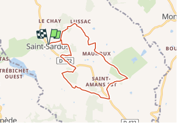
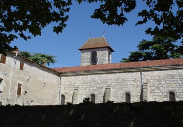
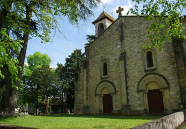
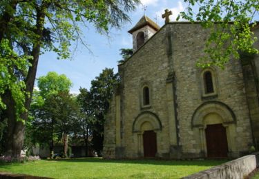
Trail Mountain bike of 8.4 km to be discovered at New Aquitaine, Lot-et-Garonne, Saint-Sardos. This trail is proposed by tracegps.

Description

Saint Sardos / Est Cté de Communes du Canton de Prayssas. Une petite balade sans difficulté, autour de l’ancienne bastide de Saint-Sardos dans un paysage de vergers de pruniers et de noisetiers. Téléchargez la fiche de cette randonnée sur le site du Tourisme du Lot et Garonne.

Elevation profile

Photos

Positioning

Country:
France
Region :
New Aquitaine
Department/Province :
Lot-et-Garonne
Municipality :
Saint-Sardos
Location:
Unknown
Start:(UTM)
299013 ; 4912766 (31T) N.

Trails nearby

Trail Walking Montpezat - Montpezat-d'Agenais, par St-Médard et Saint-Jean-de-la-Balerme - Pays de la vallée du Lot - Photo
Walking
tracegps

Walking

Medium
(1)
Montpezat, New Aquitaine, Lot-et-Garonne, France
10.7 km | 14.8 km-effort
3h 0min
Yes
Trail Walking Montpezat - Montpezat-d'Agenais, le circuit du moulin à vent - Pays de la vallée du Lot - Photo
Walking
tracegps

Walking

Medium
(2)
Montpezat, New Aquitaine, Lot-et-Garonne, France
10.5 km | 14.1 km-effort
2h 45min
Yes
Trail Walking Le Temple-sur-Lot - marche temple - Photo
Walking
damodam

Walking

Very easy
Le Temple-sur-Lot, New Aquitaine, Lot-et-Garonne, France
4.6 km | 5 km-effort
1h 37min
No
Trail Mountain bike Le Temple-sur-Lot - barrage - Photo
Mountain bike
damodam

Mountain bike

Very easy
Le Temple-sur-Lot, New Aquitaine, Lot-et-Garonne, France
6.1 km | 6.6 km-effort
48min
No
Trail Mountain bike Le Temple-sur-Lot - barrage - Photo
Mountain bike
damodam

Mountain bike

Very easy
Le Temple-sur-Lot, New Aquitaine, Lot-et-Garonne, France
6.1 km | 6.6 km-effort
48min
No
Trail Equestrian Saint-Sardos - Saint-Sardos, une bastide éphémère - Pays de la vallée du Lot - Photo
Equestrian
tracegps

Equestrian

Medium
Saint-Sardos, New Aquitaine, Lot-et-Garonne, France
8.4 km | 10.3 km-effort
1h 19min
Yes
Trail Walking Saint-Sardos - Saint-Sardos, une bastide éphémère - Pays de la vallée du Lot - Photo
Walking
tracegps

Walking

Medium
Saint-Sardos, New Aquitaine, Lot-et-Garonne, France
8.4 km | 10.3 km-effort
2h 10min
Yes
Trail Equestrian Saint-Sardos - Saint-Sardos / Lacépède, en plein coeur du Pays de Serres - Pays de la vallée du Lot - Photo
Equestrian
tracegps

Equestrian

Medium
Saint-Sardos, New Aquitaine, Lot-et-Garonne, France
14 km | 17.5 km-effort
2h 10min
Yes
Trail Mountain bike Saint-Sardos - Saint-Sardos / Lacépède, en plein coeur du Pays de Serres - Pays de la vallée du Lot - Photo
Mountain bike
tracegps

Mountain bike

Medium
Saint-Sardos, New Aquitaine, Lot-et-Garonne, France
14 km | 17.5 km-effort
1h 40min
Yes


Close
My subscriptions