Trail Walking Villeneuve-sur-Lot - Saint-Germain, l'autre colline de Villeneuve-sur-lot - Pays de la vallée du Lot - Photo

Saint-Germain, l'autre colline de Villeneuve-sur-lot - Pays de la vallée du Lot

 tracegps
tracegps

User

© OpenStreetMap contributors
Length
Length
10.2 km
Max alt
Max alt
208 m
Uphill gradient
Uphill gradient
341 m
Km-Effort
Km-Effort  
14.7 km
Min alt
Min alt
75 m
Downhill gradient
Downhill gradient
342 m
Boucle
Boucle
Yes
Creation date :
2014-12-10 00:00:00.0
Updated on :
2014-12-10 00:00:00.0

(0 Reviews)

Walking
Walking
2h45
Difficulty : Medium

Scan this QR Code to open this trail in the SityTrail application

FREE GPS app for hiking

Logo SityTrail SityTrail

IGN / Geographical institutes

Download SityTrail from the App Store Download SityTrail from Google Play

Logo SityTrail SityTrail World

The world is yours!

Download SityTrail from the App Store Download SityTrail from Google Play Download SityTrail on Huawei AppGallery

About

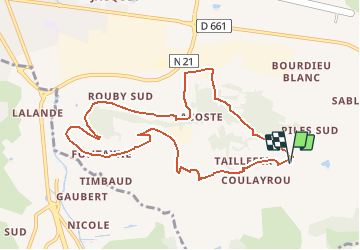
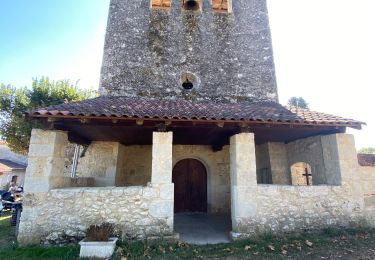
Trail Walking of 10.2 km to be discovered at New Aquitaine, Lot-et-Garonne, Villeneuve-sur-Lot. This trail is proposed by tracegps.

Description

StGermain/StMartin Cne de Villeneuvesur Lot C.C. du Villeneuvois. Les pèlerins de St-Jacques marchent sur une partie de ce circuit venant du Puy-en-Velay, via Figeac et Rocamadour. Dans le relief accidenté, le regard porte loin vers la vallée du Lot. Téléchargez la fiche de cette randonnée sur le site du Tourisme du Lot et Garonne.

Elevation profile

Photos

Positioning

Country:
France
Region :
New Aquitaine
Department/Province :
Lot-et-Garonne
Municipality :
Villeneuve-sur-Lot
Location:
Unknown
Start:(UTM)
321174 ; 4916499 (31T) N.

Trails nearby

Trail Walking Pujols - Cambes, un circuit autour d'une combe boisée - Pays de la vallée du Lot - Photo
Walking
tracegps

Walking

Easy
(1)
Pujols, New Aquitaine, Lot-et-Garonne, France
4.2 km | 5.7 km-effort
1h 15min
Yes
Trail Walking Hautefage-la-Tour - Bonneval, le circuit des trois églises - Pays de la vallée du Lot - Photo
Walking
tracegps

Walking

Medium
(1)
Hautefage-la-Tour, New Aquitaine, Lot-et-Garonne, France
10 km | 13.1 km-effort
2h 40min
Yes
Trail On foot Hautefage-la-Tour - Saint-Thomas, par Saint-Just et Piquepoul - 10.6 km - Photo
On foot
PRO

On foot

Easy
Hautefage-la-Tour, New Aquitaine, Lot-et-Garonne, France
10.2 km | 13.9 km-effort
3h 9min
Yes
Trail On foot Saint-Antoine-de-Ficalba - Bonneval, le circuit des trois églises - 10,7km - Photo
On foot
PRO

On foot

Easy
Saint-Antoine-de-Ficalba, New Aquitaine, Lot-et-Garonne, France
10.9 km | 14.2 km-effort
3h 14min
Yes
Trail On foot Penne-d'Agenais - Penne-d’Agenais, vers le château de Noaillac - 13,2km - Photo
On foot
PRO

On foot

Easy
Penne-d'Agenais, New Aquitaine, Lot-et-Garonne, France
13.1 km | 17.8 km-effort
4h 2min
Yes
Trail Mountain bike Penne-d'Agenais - 8142359 track 1522706785 672 - Photo
Mountain bike
sebcar

Mountain bike

Medium
(1)
Penne-d'Agenais, New Aquitaine, Lot-et-Garonne, France
36 km | 45 km-effort
Unknown
Yes
Trail Cycle Villeneuve-sur-Lot - de Villeneuve sur Lot à Moissac en passant par Aiguillon - Photo
Cycle
destras

Cycle

Medium
Villeneuve-sur-Lot, New Aquitaine, Lot-et-Garonne, France
129 km | 143 km-effort
6h 0min
No
Trail Walking Pujols - Cambes Pujols - Photo
Walking
jacaimee

Walking

Easy
Pujols, New Aquitaine, Lot-et-Garonne, France
11.9 km | 14.9 km-effort
2h 54min
Yes
Trail On foot Auradou - Penne-d’Agenais, Auradou, dans les coteaux nord du Pays de Serres - 23km - Photo
On foot
PRO

On foot

Easy
Auradou, New Aquitaine, Lot-et-Garonne, France
9.3 km | 11.8 km-effort
2h 41min
No


Close
My subscriptions