Trail Walking Carolles - La Vallée du Lude - Carolles - Photo

La Vallée du Lude - Carolles

 tracegps
tracegps

User

© OpenStreetMap contributors
Length
Length
6.7 km
Max alt
Max alt
69 m
Uphill gradient
Uphill gradient
138 m
Km-Effort
Km-Effort  
8.6 km
Min alt
Min alt
20 m
Downhill gradient
Downhill gradient
136 m
Boucle
Boucle
No
Creation date :
2014-12-10 00:00:00.0
Updated on :
2014-12-10 00:00:00.0

(1 Reviews)

Walking
Walking
2h30
Difficulty : Medium

Scan this QR Code to open this trail in the SityTrail application

FREE GPS app for hiking

Logo SityTrail SityTrail

IGN / Geographical institutes

Download SityTrail from the App Store Download SityTrail from Google Play

Logo SityTrail SityTrail World

The world is yours!

Download SityTrail from the App Store Download SityTrail from Google Play Download SityTrail on Huawei AppGallery

About

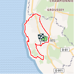
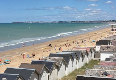
Trail Walking of 6.7 km to be discovered at Normandy, Manche, Carolles. This trail is proposed by tracegps.

Description

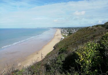
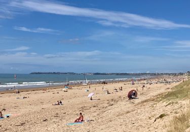
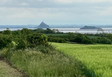
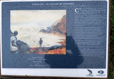
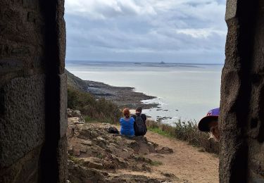
Natures et merveilles ! Sur ce circuit magnifique et varié, légendes fabuleuses et panoramas exceptionnels vous content la région. Attention à ne marcher, ni sur des ruines romaines, ni sur des fées. Des trésors vous entourent : silex taillés préhistoriques et peut-être mines d’or ! Regardez à l’horizon, vous pourrez avec un peu de chances apercevoir un grand corbeau ou un gnome assis sur le dos d’une pieuvre. Bref, des lieux qui inspirent !! Plus de détails sur le circuit (balisage, difficulté…), les points remarquables à proximité et téléchargements sur Manche Tourisme – Loisirs Randonnée GPS. Filmez la Manche envoyé par 5050tv. - L'info internationale vidéo.

Elevation profile

Photos

Positioning

Country:
France
Region :
Normandy
Department/Province :
Manche
Municipality :
Carolles
Location:
Unknown
Start:(UTM)
605572 ; 5400407 (30U) N.

Comments

Please log in to post a review or rate the element


Trails nearby

Trail Walking Carolles - Falaises de Carolles  - Photo
Walking
SyMA

Walking

Very easy
Carolles, Normandy, Manche, France
4.1 km | 5.4 km-effort
1h 6min
Yes
Trail Walking Jullouville - Jullouville - Carolles - Photo
Walking
serleb

Walking

Medium
Jullouville, Normandy, Manche, France
7.4 km | 8.6 km-effort
2h 4min
No
Trail Walking Dragey-Ronthon - Le Bec d’Andaine - Photo
Walking
serleb

Walking

Easy
Dragey-Ronthon, Normandy, Manche, France
10.2 km | 11.2 km-effort
3h 1min
Yes
Trail Walking Carolles - Carolles - Photo
Walking
serleb

Walking

Difficult
Carolles, Normandy, Manche, France
9.7 km | 12 km-effort
3h 7min
Yes
Trail Walking Carolles - Cabane Vauban et port du Lude - Photo
Walking
Vasseur Jean Marc

Walking

Easy
Carolles, Normandy, Manche, France
4.4 km | 5.7 km-effort
2h 17min
Yes
Trail Walking Carolles - cabane vauban - Photo
Walking
lionelnottat

Walking

Medium
Carolles, Normandy, Manche, France
6.8 km | 8.6 km-effort
1h 53min
Yes
Trail Mountain bike Jullouville - Bouillon Granville VTT - Photo
Mountain bike
pln

Mountain bike

Medium
Jullouville, Normandy, Manche, France
27 km | 31 km-effort
2h 51min
No
Trail Walking Saint-Jean-le-Thomas - 02-chemin du Mont Saint Michel  - Photo
Walking
bene_dictus77

Walking

Easy
Saint-Jean-le-Thomas, Normandy, Manche, France
23 km | 25 km-effort
8h 48min
No
Trail Walking Carolles - AMLC-50 Falaises de Champeaux à Carolles - Photo
Walking
dmj41

Walking

Difficult
Carolles, Normandy, Manche, France
11.6 km | 14.6 km-effort
3h 18min
Yes


Close
My subscriptions