Trail Walking Ully-Saint-Georges - Randonnée d'Ully St Georges - Photo

Randonnée d'Ully St Georges

 tracegps
tracegps

User

© OpenStreetMap contributors
Length
Length
14.5 km
Max alt
Max alt
188 m
Uphill gradient
Uphill gradient
291 m
Km-Effort
Km-Effort  
18.4 km
Min alt
Min alt
54 m
Downhill gradient
Downhill gradient
292 m
Boucle
Boucle
Yes
Creation date :
2014-12-10 00:00:00.0
Updated on :
2014-12-10 00:00:00.0

(2 Reviews)

Walking
Walking
3h40
Difficulty : Difficult

Scan this QR Code to open this trail in the SityTrail application

FREE GPS app for hiking

Logo SityTrail SityTrail

IGN / Geographical institutes

Download SityTrail from the App Store Download SityTrail from Google Play

Logo SityTrail SityTrail World

The world is yours!

Download SityTrail from the App Store Download SityTrail from Google Play Download SityTrail on Huawei AppGallery

About

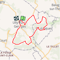
Trail Walking of 14.5 km to be discovered at Hauts-de-France, Oise, Ully-Saint-Georges. This trail is proposed by tracegps.

Description

Circuit proposé par la Communauté de Communes du Pays de Thelle. Départ de l’église d’Ully-St-Georges. Retrouver le plan du circuit sur le site de la Communauté de communes du Pays de Thelle. Retrouvez le plan du circuit sur le site de la Communauté de Communes du Pays de Thelle. Ce circuit a été numérisé par les randonneurs du CODEPEM. Merci à Jean-Marie.

Elevation profile

Photos

Positioning

Country:
France
Region :
Hauts-de-France
Department/Province :
Oise
Municipality :
Ully-Saint-Georges
Location:
Unknown
Start:(UTM)
447650 ; 5458807 (31U) N.

Comments

Please log in to post a review or rate the element


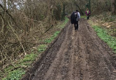
Ne pas rater la vallée de Noé une splendeur !


Trails nearby

Trail Walking Bury - Bury_Trace GPS_8,9 km - Photo
Walking
Pousscailleux

Walking

Medium
(1)
Bury, Hauts-de-France, Oise, France
8.9 km | 11.1 km-effort
2h 25min
Yes
Trail Walking Ercuis - Ercuis  - Photo
Walking
Djaie60

Walking

Easy
Ercuis, Hauts-de-France, Oise, France
13.3 km | 15.7 km-effort
3h 0min
Yes
Trail Walking Foulangues - Tour de FOULANGUES  - Photo
Walking
JEFFV

Walking

Medium
Foulangues, Hauts-de-France, Oise, France
6.2 km | 7.7 km-effort
1h 50min
Yes
Trail Walking Ully-Saint-Georges - cavillon ully st georges - Photo
Walking
magalise

Walking

Difficult
Ully-Saint-Georges, Hauts-de-France, Oise, France
12.4 km | 15.7 km-effort
3h 33min
Yes
Trail Walking Ully-Saint-Georges - ULLY ST GEORGES - Photo
Walking
Marc ROUSSELOT

Walking

Very difficult
Ully-Saint-Georges, Hauts-de-France, Oise, France
27 km | 31 km-effort
2h 36min
No
Trail sport Ercuis - Ercuis 11.7km - Photo
sport
Djaie60

sport

Very easy
Ercuis, Hauts-de-France, Oise, France
11.7 km | 13.5 km-effort
Unknown
Yes
Trail On foot Ully-Saint-Georges - Cavillon 11.4km - Photo
On foot
Djaie60

On foot

Very easy
Ully-Saint-Georges, Hauts-de-France, Oise, France
11.4 km | 13.2 km-effort
Unknown
Yes
Trail On foot Ercuis - Ercuis 11.4km - Photo
On foot
Djaie60

On foot

Very easy
Ercuis, Hauts-de-France, Oise, France
11.4 km | 13.6 km-effort
Unknown
Yes
Trail On foot Ercuis - Ercuis 10 km - Photo
On foot
Djaie60

On foot

Very easy
Ercuis, Hauts-de-France, Oise, France
10.5 km | 12.1 km-effort
Unknown
Yes


Close
My subscriptions