Trail Walking Boeschepe - Sentier de l'Ondank Meulen - Boeschèpe - Photo

Sentier de l'Ondank Meulen - Boeschèpe

 tracegps
tracegps

User

© OpenStreetMap contributors
Length
Length
3.3 km
Max alt
Max alt
133 m
Uphill gradient
Uphill gradient
79 m
Km-Effort
Km-Effort  
4.4 km
Min alt
Min alt
51 m
Downhill gradient
Downhill gradient
79 m
Boucle
Boucle
Yes
Creation date :
2014-12-10 00:00:00.0
Updated on :
2014-12-10 00:00:00.0

(1 Reviews)

Walking
Walking
1h00
Difficulty : Easy

Scan this QR Code to open this trail in the SityTrail application

FREE GPS app for hiking

Logo SityTrail SityTrail

IGN / Geographical institutes

Download SityTrail from the App Store Download SityTrail from Google Play

Logo SityTrail SityTrail World

The world is yours!

Download SityTrail from the App Store Download SityTrail from Google Play Download SityTrail on Huawei AppGallery

About

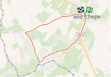
Trail Walking of 3.3 km to be discovered at Hauts-de-France, Nord, Boeschepe. This trail is proposed by tracegps.

Description

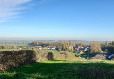
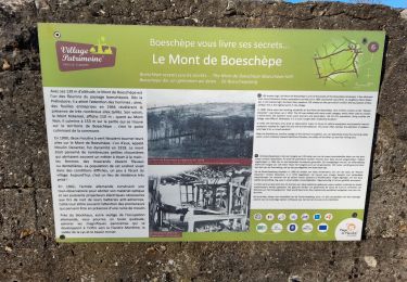
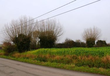
Circuit proposé par le Comité Départemental du Tourisme du Nord et l’ Office de Tourisme de Bailleul. Fiche n° 21 de la pochette «Il était une fois les Monts de Flandre» Départ du parking de l’église de Boeschèpe. Promenade familiale au départ du plus haut village des Flandres (74 m) après Cassel. Sans difficultés, il emprunte des routes calmes, longe bois, bocage et offre de belles perspectives sur les environs. Retrouvez cette randonnée sur le site du Comité Départemental du Tourisme du Nord.

Elevation profile

Photos

Positioning

Country:
France
Region :
Hauts-de-France
Department/Province :
Nord
Municipality :
Boeschepe
Location:
Unknown
Start:(UTM)
478234 ; 5627650 (31U) N.

Comments

Please log in to post a review or rate the element


Trails nearby

Trail Walking Berthen - Autour du monastère - Godewaersvelde - Photo
Walking
tracegps

Walking

Difficult
(3)
Berthen, Hauts-de-France, Nord, France
11.8 km | 15.6 km-effort
3h 0min
Yes
Trail Walking Heuvelland - Loker - Le Mont Rouge - Photo
Walking
tracegps

Walking

Medium
(2)
Heuvelland, Flanders, West Flanders, Belgium
8.7 km | 10.8 km-effort
2h 19min
Yes
Trail On foot Heuvelland - Tweebergen wandelroute - Photo
On foot
PRO

On foot

Easy
Heuvelland, Flanders, West Flanders, Belgium
7.3 km | 9 km-effort
2h 2min
Yes
Trail Walking Heuvelland - Westouter langs tweetermen - Photo
Walking
Wesley Samyn

Walking

Difficult
(1)
Heuvelland, Flanders, West Flanders, Belgium
7.5 km | 9.1 km-effort
2h 4min
Yes
Trail Walking Saint-Jans-Cappel - sentier des jacynthes - Photo
Walking
Bernard.voyageur

Walking

Medium
(1)
Saint-Jans-Cappel, Hauts-de-France, Nord, France
7.3 km | 9.2 km-effort
2h 1min
Yes
Trail Walking Bailleul - camping de la Ferme des Saules à côté de Bailleul, arrivée Deulemont - Photo
Walking
jeff2

Walking

Medium
Bailleul, Hauts-de-France, Nord, France
32 km | 34 km-effort
9h 10min
No
Trail Walking Heuvelland - Monts Rouge et Noir - Photo
Walking
Greg813

Walking

Difficult
Heuvelland, Flanders, West Flanders, Belgium
24 km | 30 km-effort
5h 27min
Yes
Trail Walking Boeschepe - Boeschepe - Photo
Walking
fif59280

Walking

Difficult
Boeschepe, Hauts-de-France, Nord, France
10.6 km | 13 km-effort
2h 26min
No
Trail On foot Poperinge - Helleketelbos - Photo
On foot
PRO

On foot

Easy
Poperinge, Flanders, West Flanders, Belgium
10.8 km | 12.5 km-effort
2h 49min
Yes


Close
My subscriptions