Trail On foot Heuvelland - Tweebergen wandelroute - Photo

Tweebergen wandelroute

Tous les sentiers balisés d’Europe PRO

© OpenStreetMap contributors
Length
Length
7.3 km
Max alt
Max alt
127 m
Uphill gradient
Uphill gradient
124 m
Km-Effort
Km-Effort  
9 km
Min alt
Min alt
34 m
Downhill gradient
Downhill gradient
123 m
Boucle
Boucle
Yes
Signpost
Signpost
Creation date :
2022-02-09 15:07:42.121
Updated on :
2022-02-09 17:54:02.796

(0 Reviews)

On foot
On foot
2h02
Difficulty : Easy

Scan this QR Code to open this trail in the SityTrail application

FREE GPS app for hiking

Logo SityTrail SityTrail

IGN / Geographical institutes

Download SityTrail from the App Store Download SityTrail from Google Play

Logo SityTrail SityTrail World

The world is yours!

Download SityTrail from the App Store Download SityTrail from Google Play Download SityTrail on Huawei AppGallery

About

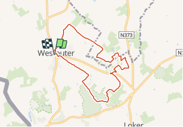
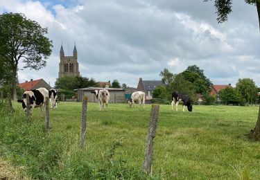
Trail On foot of 7.3 km to be discovered at Flanders, West Flanders, Heuvelland. This trail is proposed by SityTrail - itinéraires balisés pédestres.

Description

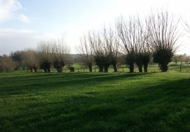
De Tweebergenwandelroute vertrekt vanuit de dorpskom van Westouter. Daarna wandel je naar de Sulferberg (88m) en het gelijknamige natuurreservaat. De toch gaat verder richting Rodeberg. Eenmaal boven wacht een avontuurlijke afdaling langs het Hellegat, een diep uitgesneden dal dat grotendeels bebost is. De terugweg leidt door het Kotje Piepersbos. Je wandelt terug naar

Photos

Positioning

Country:
Belgium
Region :
Flanders
Department/Province :
West Flanders
Municipality :
Heuvelland
Location:
Westouter
Start:(UTM)
482092 ; 5627372 (31U) N.

Trails nearby

Trail Walking Heuvelland - Loker - Le Mont Rouge - Photo
Walking
tracegps

Walking

Medium
(2)
Heuvelland, Flanders, West Flanders, Belgium
8.7 km | 10.8 km-effort
2h 19min
Yes
Trail Walking Heuvelland - Westouter langs tweetermen - Photo
Walking
Wesley Samyn

Walking

Difficult
(1)
Heuvelland, Flanders, West Flanders, Belgium
7.5 km | 9.1 km-effort
2h 4min
Yes
Trail Walking Saint-Jans-Cappel - sentier des jacynthes - Photo
Walking
Bernard.voyageur

Walking

Medium
(1)
Saint-Jans-Cappel, Hauts-de-France, Nord, France
7.3 km | 9.2 km-effort
2h 1min
Yes
Trail Walking Bailleul - camping de la Ferme des Saules à côté de Bailleul, arrivée Deulemont - Photo
Walking
jeff2

Walking

Medium
Bailleul, Hauts-de-France, Nord, France
32 km | 34 km-effort
9h 10min
No
Trail Walking Heuvelland - Dranouter 12,3 km - Photo
Walking
GUIDE
rvapeldo

Walking

Easy
Heuvelland, Flanders, West Flanders, Belgium
12.4 km | 14.5 km-effort
3h 32min
Yes
Trail Walking Heuvelland - Monts Rouge et Noir - Photo
Walking
Greg813

Walking

Difficult
Heuvelland, Flanders, West Flanders, Belgium
24 km | 30 km-effort
5h 27min
Yes
Trail Walking Boeschepe - Boeschepe - Photo
Walking
fif59280

Walking

Difficult
Boeschepe, Hauts-de-France, Nord, France
10.6 km | 13 km-effort
2h 26min
No
Trail On foot Poperinge - Zevekotepad Reningelst - Photo
On foot
PRO

On foot

Easy
Poperinge, Flanders, West Flanders, Belgium
6.9 km | 7.9 km-effort
1h 47min
Yes
Trail Walking Heuvelland - Loker 18,2 km - Photo
Walking
GUIDE
rvapeldo

Walking

Medium
Heuvelland, Flanders, West Flanders, Belgium
18.3 km | 23 km-effort
5h 14min
Yes


Close
My subscriptions