Trail Walking Rethondes - Circuit des 17 frères - Rethondes - Photo

Circuit des 17 frères - Rethondes

 tracegps
tracegps

User

© OpenStreetMap contributors
Length
Length
7.8 km
Max alt
Max alt
80 m
Uphill gradient
Uphill gradient
91 m
Km-Effort
Km-Effort  
9 km
Min alt
Min alt
35 m
Downhill gradient
Downhill gradient
91 m
Boucle
Boucle
Yes
Creation date :
2014-12-10 00:00:00.0
Updated on :
2014-12-10 00:00:00.0

(0 Reviews)

Walking
Walking
2h00
Difficulty : Easy

Scan this QR Code to open this trail in the SityTrail application

FREE GPS app for hiking

Logo SityTrail SityTrail

IGN / Geographical institutes

Download SityTrail from the App Store Download SityTrail from Google Play

Logo SityTrail SityTrail World

The world is yours!

Download SityTrail from the App Store Download SityTrail from Google Play Download SityTrail on Huawei AppGallery

About

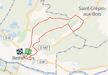
Trail Walking of 7.8 km to be discovered at Hauts-de-France, Oise, Rethondes. This trail is proposed by tracegps.

Description

Circuit proposé par l’Office de Tourisme de Pierrefonds. Départ de la place de l’église de Rethondes. Retrouvez ce circuit sur le site de l’Office de Tourisme de Pierrefonds. Ce circuit a été numérisé par les randonneurs du CODEPEM. Merci à Jean-Marie.

Elevation profile

Photos

Positioning

Country:
France
Region :
Hauts-de-France
Department/Province :
Oise
Municipality :
Rethondes
Location:
Unknown
Start:(UTM)
495678 ; 5473741 (31U) N.

Trails nearby

Trail Walking Choisy-au-Bac - en forêt de Laigue_9_06_2020_Chemin du Fau Bidaud et la Route de Royaumont - Photo
Walking

Walking

Very difficult
(1)
Choisy-au-Bac, Hauts-de-France, Oise, France
9.6 km | 12.8 km-effort
3h 0min
Yes
Trail Walking Rethondes - en forêt de Laigue_4_08_2019_Mont du Fouilleux_Mont des Singes_Marais de Francière - Photo
Walking

Walking

Very difficult
(1)
Rethondes, Hauts-de-France, Oise, France
14.8 km | 17.7 km-effort
4h 49min
Yes
Trail Walking Vieux-Moulin - Rando douce Vieux moulin 14/8/2022 - Photo
Walking
pascha

Walking

Medium
(1)
Vieux-Moulin, Hauts-de-France, Oise, France
8.7 km | 10.1 km-effort
2h 14min
Yes
Trail Walking Vieux-Moulin - Gorges du Han - ATPC ARVAL - Photo
Walking
pascha

Walking

Very easy
(1)
Vieux-Moulin, Hauts-de-France, Oise, France
13.2 km | 16 km-effort
2h 42min
Yes
Trail Walking Compiègne - Compiegne rond point de l’Armistice 13,4 km - Photo
Walking
GUIDE
rvapeldo

Walking

Easy
Compiègne, Hauts-de-France, Oise, France
13.4 km | 17.5 km-effort
3h 36min
Yes
Trail Walking Compiègne - en forêt de Compiègne_47_autour des Beaux Monts - Photo
Walking

Walking

Medium
Compiègne, Hauts-de-France, Oise, France
4.8 km | 6.4 km-effort
1h 27min
No
Trail On foot Trosly-Breuil - Le Mont-Collet - Photo
On foot
PRO

On foot

Easy
Trosly-Breuil, Hauts-de-France, Oise, France
4.9 km | 6.6 km-effort
1h 29min
Yes
Trail On foot Vieux-Moulin - Promenade de Vieux moulin - Photo
On foot
PRO

On foot

Easy
Vieux-Moulin, Hauts-de-France, Oise, France
5.3 km | 7.4 km-effort
1h 40min
Yes
Trail On foot Compiègne - Promenade du Point de Vue des beaux Monts - Photo
On foot
PRO

On foot

Easy
Compiègne, Hauts-de-France, Oise, France
3.1 km | 3.8 km-effort
51min
Yes


Close
My subscriptions