Trail Walking Maraye-en-Othe - Le circuit des Voirloups - Maraye-en-Othe - Photo

Le circuit des Voirloups - Maraye-en-Othe

 tracegps
tracegps

User

© OpenStreetMap contributors
Length
Length
19.1 km
Max alt
Max alt
296 m
Uphill gradient
Uphill gradient
374 m
Km-Effort
Km-Effort  
24 km
Min alt
Min alt
185 m
Downhill gradient
Downhill gradient
369 m
Boucle
Boucle
Yes
Creation date :
2014-12-10 00:00:00.0
Updated on :
2014-12-10 00:00:00.0

(1 Reviews)

Walking
Walking
4h49
Difficulty : Very difficult

Scan this QR Code to open this trail in the SityTrail application

FREE GPS app for hiking

Logo SityTrail SityTrail

IGN / Geographical institutes

Download SityTrail from the App Store Download SityTrail from Google Play

Logo SityTrail SityTrail World

The world is yours!

Download SityTrail from the App Store Download SityTrail from Google Play Download SityTrail on Huawei AppGallery

About

Trail Walking of 19.1 km to be discovered at Grand Est, Aube, Maraye-en-Othe. This trail is proposed by tracegps.

Description

Circuit proposé par l’Office de Tourisme du Pays d’Othe. Départ de la place du jet d’eau devant la mairie de Maraye-en-Othe. Retrouvez ce circuit sur le site de l’Office du Tourisme. Circuit interdit en période de chasse. Ce circuit a été numérisé par les randonneurs du CODEPEM. Merci à Jean-Marie.

Elevation profile

Photos

Positioning

Country:
France
Region :
Grand Est
Department/Province :
Aube
Municipality :
Maraye-en-Othe
Location:
Unknown
Start:(UTM)
563398 ; 5334793 (31U) N.

Comments

Please log in to post a review or rate the element


merci


Trails nearby

Trail Walking Saint-Mards-en-Othe - De place en place - Saint Mards en Othe - Photo
Walking
tracegps

Walking

Difficult
(1)
Saint-Mards-en-Othe, Grand Est, Aube, France
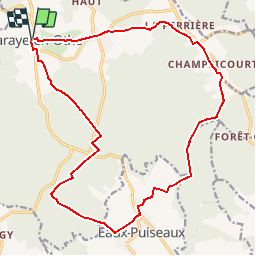
16.1 km | 19.8 km-effort
4h 0min
Yes
Trail Walking Bercenay-en-Othe - Bercenay - Photo
Walking
FPortier

Walking

Medium
Bercenay-en-Othe, Grand Est, Aube, France
9.2 km | 12.2 km-effort
2h 24min
Yes
Trail Walking Maraye-en-Othe - Les Boulins - Photo
Walking
FPortier

Walking

Easy
Maraye-en-Othe, Grand Est, Aube, France
8.9 km | 10.8 km-effort
2h 21min
Yes
Trail Walking Maraye-en-Othe - Maraye (11+13km) le 21/07/2020 - Photo
Walking
francis1952

Walking

Medium
Maraye-en-Othe, Grand Est, Aube, France
25 km | 30 km-effort
5h 14min
Yes
Trail Cycle Saint-Mards-en-Othe - Circuit de Saint-Mards-en-Othe - Photo
Cycle
tracegps

Cycle

Easy
Saint-Mards-en-Othe, Grand Est, Aube, France
26 km | 31 km-effort
1h 30min
Yes
Trail Walking Eaux-Puiseaux - Circuit des trois Monts - Eaux-Puiseaux - Photo
Walking
tracegps

Walking

Very difficult
Eaux-Puiseaux, Grand Est, Aube, France
14.7 km | 19 km-effort
3h 45min
Yes
Trail Walking Maraye-en-Othe - Les Vergers de Champcharme - Maraye-en-Othe - Photo
Walking
tracegps

Walking

Difficult
Maraye-en-Othe, Grand Est, Aube, France
14.3 km | 18.6 km-effort
3h 34min
Yes
Trail Walking Maraye-en-Othe - Maraye,Nogent,Vosnon,Puiseaux,Chenu,Chamsicourt - Photo
Walking
francis1952

Walking

Difficult
Maraye-en-Othe, Grand Est, Aube, France
31 km | 39 km-effort
6h 11min
Yes
Trail Walking Maraye-en-Othe - Maraye 26km le 08.10.2021 - Photo
Walking
francis1952

Walking

Difficult
Maraye-en-Othe, Grand Est, Aube, France
26 km | 32 km-effort
5h 27min
Yes


Close
My subscriptions