Trail Walking Ervy-le-Châtel - Circuit des Chaumes Blanches - Ervy-le-Chatel - Photo

Circuit des Chaumes Blanches - Ervy-le-Chatel

 tracegps
tracegps

User

© OpenStreetMap contributors
Length
Length
6.3 km
Max alt
Max alt
168 m
Uphill gradient
Uphill gradient
78 m
Km-Effort
Km-Effort  
7.3 km
Min alt
Min alt
129 m
Downhill gradient
Downhill gradient
78 m
Boucle
Boucle
Yes
Creation date :
2014-12-10 00:00:00.0
Updated on :
2014-12-10 00:00:00.0

(0 Reviews)

Walking
Walking
1h34
Difficulty : Easy

Scan this QR Code to open this trail in the SityTrail application

FREE GPS app for hiking

Logo SityTrail SityTrail

IGN / Geographical institutes

Download SityTrail from the App Store Download SityTrail from Google Play

Logo SityTrail SityTrail World

The world is yours!

Download SityTrail from the App Store Download SityTrail from Google Play Download SityTrail on Huawei AppGallery

About

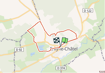
Trail Walking of 6.3 km to be discovered at Grand Est, Aube, Ervy-le-Châtel. This trail is proposed by tracegps.

Description

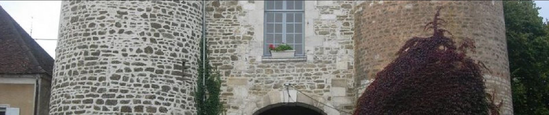
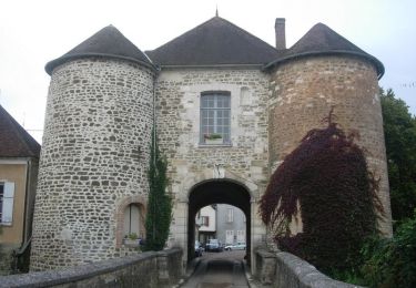
Circuit proposé par l’Office du Tourisme du Chaourçois en Pays d’Armance. Départ de la Halle d’Ervy-le-Chatel. Dans son écrin de verdure composé de forêts et de prairies, cette petite cité pittoresque doit son calme à sa situation à l’écart des grands axes de circulation. Autrefois puissante place forte aux confins de la Champagne et de la Bourgogne, Elle est bâtie sur une colline (160 m) qui donne l’impression de la Champagne Humide drainée par les eaux paresseuses de l’Armance. Ce site exceptionnel a été très tôt occupé par une forteresse militaire ceinturée de larges remparts et de profonds fossés qui ont donné à la vieille ville sa double structure circulaire. Elle a conservée la porte St-Nicolas, seule porte de la ville fortifiée subsistant dans l’Aube. Retrouvez ce circuit sur le site de l’Office du Tourisme.

Elevation profile

Photos

Positioning

Country:
France
Region :
Grand Est
Department/Province :
Aube
Municipality :
Ervy-le-Châtel
Location:
Unknown
Start:(UTM)
567925 ; 5321343 (31U) N.

Trails nearby

Trail Walking Ervy-le-Châtel - ERVY LE CHATEL, au départ de la halle - Photo
Walking
jeannine grandjean

Walking

Medium
(1)
Ervy-le-Châtel, Grand Est, Aube, France
10.1 km | 11.4 km-effort
2h 35min
Yes
Trail Walking Davrey - Circuit de Davrey - Photo
Walking
tracegps

Walking

Very difficult
Davrey, Grand Est, Aube, France
16.4 km | 17.8 km-effort
4h 10min
Yes
Trail Walking Ervy-le-Châtel - Circuit du bois du Parc - Ervy-le-Chatel - Photo
Walking
tracegps

Walking

Medium
Ervy-le-Châtel, Grand Est, Aube, France
10.1 km | 11.5 km-effort
2h 30min
Yes
Trail Walking Ervy-le-Châtel - Circuit de l'Armance - Ervy-le-Chatel - Photo
Walking
tracegps

Walking

Easy
Ervy-le-Châtel, Grand Est, Aube, France
4.8 km | 5.7 km-effort
1h 15min
Yes
Trail Cycle Ervy-le-Châtel - Pays d'Armance : à la découverte d'un village perché  - Ervy le Châtel - Photo
Cycle
tracegps

Cycle

Difficult
Ervy-le-Châtel, Grand Est, Aube, France
75 km | 86 km-effort
4h 0min
Yes
Trail Walking Davrey - davrey - Photo
Walking
bougnaou

Walking

Medium
Davrey, Grand Est, Aube, France
17.3 km | 18.8 km-effort
6h 0min
Yes
Trail Walking Davrey - Davrey (10) - Circuit de Davrey - Photo
Walking
temmichel

Walking

Difficult
Davrey, Grand Est, Aube, France
15.9 km | 17.2 km-effort
3h 55min
Yes
Trail Walking Ervy-le-Châtel - ervy nocturne 23 - Photo
Walking
bougnaou

Walking

Easy
Ervy-le-Châtel, Grand Est, Aube, France
11.5 km | 12.9 km-effort
2h 45min
Yes
Trail Walking Davrey - Davrey balisage 23 - Photo
Walking
bougnaou

Walking

Medium
Davrey, Grand Est, Aube, France
17.7 km | 19.1 km-effort
4h 51min
Yes


Close
My subscriptions