Trail Cycle Ervy-le-Châtel - Pays d'Armance : à la découverte d'un village perché  - Ervy le Châtel - Photo

Pays d'Armance : à la découverte d'un village perché - Ervy le Châtel

 tracegps
tracegps

User

© OpenStreetMap contributors
Length
Length
75 km
Max alt
Max alt
291 m
Uphill gradient
Uphill gradient
837 m
Km-Effort
Km-Effort  
86 km
Min alt
Min alt
108 m
Downhill gradient
Downhill gradient
840 m
Boucle
Boucle
Yes
Creation date :
2014-12-10 00:00:00.0
Updated on :
2014-12-10 00:00:00.0

(0 Reviews)

Cycle
Cycle
4h00
Difficulty : Difficult

Scan this QR Code to open this trail in the SityTrail application

FREE GPS app for hiking

Logo SityTrail SityTrail

IGN / Geographical institutes

Download SityTrail from the App Store Download SityTrail from Google Play

Logo SityTrail SityTrail World

The world is yours!

Download SityTrail from the App Store Download SityTrail from Google Play Download SityTrail on Huawei AppGallery

About

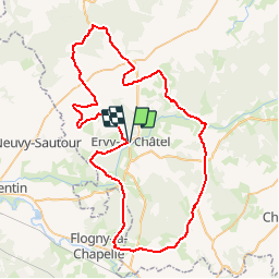
Trail Cycle of 75 km to be discovered at Grand Est, Aube, Ervy-le-Châtel. This trail is proposed by tracegps.

Description

Proposé par le Comité Départemental du Tourisme de l'Aube, un circuit créé et validé par la Fédération Départementale du Cyclotourisme de l’Aube. Pays d’Armance : à la découverte d’un village perché – 75 km - Ervy-le-Châtel et sa halle circulaire - Eglise de Racines - Eaux-Puiseaux : musée du cidre - Auxon : Eglise Saint-Loup (XVIème siècle).

Elevation profile

Photos

Points of interest

Point of interest Ervy-le-Châtel - cycloguide N?06 Pays d?Armance : ? la d?couverte d 74.839 km - Photo
tracegps

Positioning

Country:
France
Region :
Grand Est
Department/Province :
Aube
Municipality :
Ervy-le-Châtel
Location:
Unknown
Start:(Dec)
Start:(UTM)
567969 ; 5321206 (31U) N.

Trails nearby

Trail Walking Ervy-le-Châtel - ERVY LE CHATEL, au départ de la halle - Photo
Walking
jeannine grandjean

Walking

Medium
(1)
Ervy-le-Châtel, Grand Est, Aube, France
10.1 km | 11.4 km-effort
2h 35min
Yes
Trail Walking Davrey - Circuit de Davrey - Photo
Walking
tracegps

Walking

Very difficult
Davrey, Grand Est, Aube, France
16.4 km | 17.8 km-effort
4h 10min
Yes
Trail Walking Ervy-le-Châtel - Circuit des Chaumes Blanches - Ervy-le-Chatel - Photo
Walking
tracegps

Walking

Easy
Ervy-le-Châtel, Grand Est, Aube, France
6.3 km | 7.3 km-effort
1h 34min
Yes
Trail Walking Ervy-le-Châtel - Circuit du bois du Parc - Ervy-le-Chatel - Photo
Walking
tracegps

Walking

Medium
Ervy-le-Châtel, Grand Est, Aube, France
10.1 km | 11.5 km-effort
2h 30min
Yes
Trail Walking Ervy-le-Châtel - Circuit de l'Armance - Ervy-le-Chatel - Photo
Walking
tracegps

Walking

Easy
Ervy-le-Châtel, Grand Est, Aube, France
4.8 km | 5.7 km-effort
1h 15min
Yes
Trail Walking Davrey - davrey - Photo
Walking
bougnaou

Walking

Medium
Davrey, Grand Est, Aube, France
17.3 km | 18.8 km-effort
6h 0min
Yes
Trail Walking Davrey - Davrey (10) - Circuit de Davrey - Photo
Walking
temmichel

Walking

Difficult
Davrey, Grand Est, Aube, France
15.9 km | 17.2 km-effort
3h 55min
Yes
Trail Walking Ervy-le-Châtel - ervy nocturne 23 - Photo
Walking
bougnaou

Walking

Easy
Ervy-le-Châtel, Grand Est, Aube, France
11.5 km | 12.9 km-effort
2h 45min
Yes
Trail Walking Davrey - Davrey balisage 23 - Photo
Walking
bougnaou

Walking

Medium
Davrey, Grand Est, Aube, France
17.7 km | 19.1 km-effort
4h 51min
Yes


Close
My subscriptions