Trail Walking Montigny-les-Monts - Circuit de Coulore - Montigny-les-Monts - Photo

Circuit de Coulore - Montigny-les-Monts

 tracegps
tracegps

User

© OpenStreetMap contributors
Length
Length
8.4 km
Max alt
Max alt
184 m
Uphill gradient
Uphill gradient
96 m
Km-Effort
Km-Effort  
9.7 km
Min alt
Min alt
144 m
Downhill gradient
Downhill gradient
96 m
Boucle
Boucle
Yes
Creation date :
2014-12-10 00:00:00.0
Updated on :
2014-12-10 00:00:00.0

(0 Reviews)

Walking
Walking
2h04
Difficulty : Medium

Scan this QR Code to open this trail in the SityTrail application

FREE GPS app for hiking

Logo SityTrail SityTrail

IGN / Geographical institutes

Download SityTrail from the App Store Download SityTrail from Google Play

Logo SityTrail SityTrail World

The world is yours!

Download SityTrail from the App Store Download SityTrail from Google Play Download SityTrail on Huawei AppGallery

About

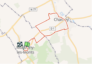
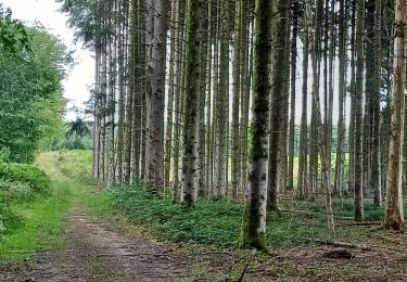
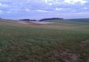
Trail Walking of 8.4 km to be discovered at Grand Est, Aube, Montigny-les-Monts. This trail is proposed by tracegps.

Description

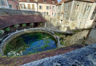
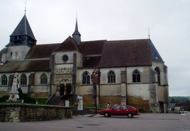
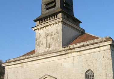
Circuit proposé par l’Office du Tourisme du Chaourçois en Pays d’Armance . Départ de la mairie de Montigny-les-Monts ou de la salle polyvalente de Chamoy (4,5 km). Le 10 novembre 1521, Chamoy s’émancipe de la tutelle religieuse de St Phal : une transaction sur parchemin entre le seigneur et les habitants de Chamoy d’une part et le curé de St Phal d’autre part. L’église Vierge Marie Immaculé Conception des 16e et 19e siècles, se compose d’une très belle statutaire du 17e et de vitraux classés protégés. Chamoy est traversé par la Trémagne, qui alimentait les douves de l’ancien château, totalement démoli. Retrouvez ce circuit sur le site de l’Office du Tourisme.

Elevation profile

Photos

Positioning

Country:
France
Region :
Grand Est
Department/Province :
Aube
Municipality :
Montigny-les-Monts
Location:
Unknown
Start:(UTM)
570387 ; 5328268 (31U) N.

Trails nearby

Trail Road bike Auxon - EXT80 Auxon-01 - Photo
Road bike
Specialized77

Road bike

Easy
Auxon, Grand Est, Aube, France
79 km | 91 km-effort
3h 30min
Yes
Trail Walking Eaux-Puiseaux - Circuit des trois Monts - Eaux-Puiseaux - Photo
Walking
tracegps

Walking

Very difficult
Eaux-Puiseaux, Grand Est, Aube, France
14.7 km | 19 km-effort
3h 45min
Yes
Trail Walking Saint-Phal - Chenu Vosnon 33km le 29.07.2021 - Photo
Walking
francis1952

Walking

Difficult
Saint-Phal, Grand Est, Aube, France
34 km | 42 km-effort
6h 34min
Yes
Trail Walking Saint-Phal - St-Phal - Photo
Walking
pkermaidic

Walking

Easy
Saint-Phal, Grand Est, Aube, France
7.3 km | 9.1 km-effort
1h 57min
Yes
Trail Walking Saint-Phal - Circuit du Pirancey - St Phal - Photo
Walking
tracegps

Walking

Medium
Saint-Phal, Grand Est, Aube, France
9 km | 10.2 km-effort
2h 15min
Yes
Trail Walking Eaux-Puiseaux - eau p - Photo
Walking
maraisch

Walking

Easy
Eaux-Puiseaux, Grand Est, Aube, France
22 km | 28 km-effort
6h 22min
Yes
Trail Walking Saint-Phal - FORÊT CHENU le 05.09.23 10 kms - Photo
Walking
COTELEVELYNE

Walking

Difficult
Saint-Phal, Grand Est, Aube, France
10.3 km | 13.1 km-effort
2h 58min
Yes
Trail Walking Saint-Phal - Forêt chenu 10km réel - Photo
Walking
rando-nico

Walking

Difficult
Saint-Phal, Grand Est, Aube, France
9.9 km | 12.7 km-effort
3h 10min
Yes
Trail Walking Eaux-Puiseaux - Eaux puiseaux - Photo
Walking
richardetchantal

Walking

Easy
Eaux-Puiseaux, Grand Est, Aube, France
11.9 km | 14.8 km-effort
3h 4min
Yes


Close
My subscriptions