Trail Cycle Vigneulles-lès-Hattonchâtel - Promenade à travers bois, entre architecture, art et histoire, Circuit n° 3, - Hattonchâtel - Photo

Promenade à travers bois, entre architecture, art et histoire, Circuit n° 3, - Hattonchâtel

 tracegps
tracegps

User

© OpenStreetMap contributors
Length
Length
34 km
Max alt
Max alt
414 m
Uphill gradient
Uphill gradient
458 m
Km-Effort
Km-Effort  
40 km
Min alt
Min alt
211 m
Downhill gradient
Downhill gradient
458 m
Boucle
Boucle
Yes
Creation date :
2014-12-10 00:00:00.0
Updated on :
2014-12-10 00:00:00.0

(0 Reviews)

Cycle
Cycle
1h45
Difficulty : Medium

Scan this QR Code to open this trail in the SityTrail application

FREE GPS app for hiking

Logo SityTrail SityTrail

IGN / Geographical institutes

Download SityTrail from the App Store Download SityTrail from Google Play

Logo SityTrail SityTrail World

The world is yours!

Download SityTrail from the App Store Download SityTrail from Google Play Download SityTrail on Huawei AppGallery

About

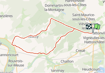
Trail Cycle of 34 km to be discovered at Grand Est, Meuse, Vigneulles-lès-Hattonchâtel. This trail is proposed by tracegps.

Description

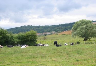
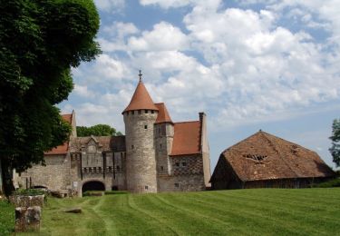
Le Parc Naturel Régional de Lorraine vous propose une promenade idéale lors des fortes chaleurs à l’ombre des arbres en forêts des Côtes de meuse. Ce circuit relie sur les hauteurs, le village médiéval d’Hattonchâtel doté d’un héritage architectural remarquable ! Départ d’Hattonchâtel. Retrouvez ici le plan et descriptif du circuit. Vous pouvez obtenir le guide par courrier auprés du Parc Naturel Régional de Lorraine

Elevation profile

Photos

Positioning

Country:
France
Region :
Grand Est
Department/Province :
Meuse
Municipality :
Vigneulles-lès-Hattonchâtel
Location:
Hattonchâtel
Start:(UTM)
697523 ; 5430041 (31U) N.

Trails nearby

Trail Walking Vigneulles-lès-Hattonchâtel - balade ton bleu des amis de la côte  - Photo
Walking
stef789

Walking

Very easy
(1)
Vigneulles-lès-Hattonchâtel, Grand Est, Meuse, France
6.5 km | 8.2 km-effort
1h 35min
No
Trail Walking Lamorville - L'abbaye de l'etanche - Photo
Walking
fraxin

Walking

Easy
(1)
Lamorville, Grand Est, Meuse, France
9.9 km | 12.9 km-effort
2h 18min
Yes
Trail Cycle Saint-Maurice-sous-les-Côtes - Lac de Madine et Côtes de Meuse - St Maurice sous les Côtes - Photo
Cycle
tracegps

Cycle

Very difficult
Saint-Maurice-sous-les-Côtes, Grand Est, Meuse, France
79 km | 93 km-effort
5h 0min
Yes
Trail Cycle Vigneulles-lès-Hattonchâtel - Balade dans les Côtes de Meuse - Vigneulles-les-Hattonchâtel - Photo
Cycle
tracegps

Cycle

Medium
Vigneulles-lès-Hattonchâtel, Grand Est, Meuse, France
27 km | 32 km-effort
1h 30min
Yes
Trail Mountain bike Saint-Maurice-sous-les-Côtes - Les Côtes de Meuse - St-Maurice-sous-les-Côtes - Photo
Mountain bike
tracegps

Mountain bike

Difficult
(1)
Saint-Maurice-sous-les-Côtes, Grand Est, Meuse, France
17.8 km | 22 km-effort
2h 0min
Yes
Trail Walking Saint-Maurice-sous-les-Côtes - Les Côtes de Meuse - St-Maurice-sous-les-Côtes - Photo
Walking
tracegps

Walking

Very difficult
Saint-Maurice-sous-les-Côtes, Grand Est, Meuse, France
17.8 km | 22 km-effort
4h 30min
Yes
Trail Horseback riding Hannonville-sous-les-Côtes - Foxycamp - Photo
Horseback riding
Mercalta

Horseback riding

Medium
Hannonville-sous-les-Côtes, Grand Est, Meuse, France
19.4 km | 24 km-effort
4h 6min
Yes
Trail Walking Saint-Maurice-sous-les-Côtes - Saint Maurice en haut des Côtes  - Photo
Walking
kikkko

Walking

Medium
Saint-Maurice-sous-les-Côtes, Grand Est, Meuse, France
15.3 km | 18.5 km-effort
2h 41min
No
Trail Road bike Vigneulles-lès-Hattonchâtel - AR VIGNEULES/VERDUN - Photo
Road bike
PascalKvtt

Road bike

Very difficult
Vigneulles-lès-Hattonchâtel, Grand Est, Meuse, France
104 km | 120 km-effort
7h 17min
No


Close
My subscriptions