Trail Cycle Carentoir - Circuit de Carentoir  - Photo

Circuit de Carentoir

 tracegps
tracegps

User

© OpenStreetMap contributors
Length
Length
33 km
Max alt
Max alt
97 m
Uphill gradient
Uphill gradient
447 m
Km-Effort
Km-Effort  
39 km
Min alt
Min alt
14 m
Downhill gradient
Downhill gradient
447 m
Boucle
Boucle
Yes
Creation date :
2014-12-10 00:00:00.0
Updated on :
2014-12-10 00:00:00.0

(0 Reviews)

Cycle
Cycle
3h30
Difficulty : Difficult

Scan this QR Code to open this trail in the SityTrail application

FREE GPS app for hiking

Logo SityTrail SityTrail

IGN / Geographical institutes

Download SityTrail from the App Store Download SityTrail from Google Play

Logo SityTrail SityTrail World

The world is yours!

Download SityTrail from the App Store Download SityTrail from Google Play Download SityTrail on Huawei AppGallery

About

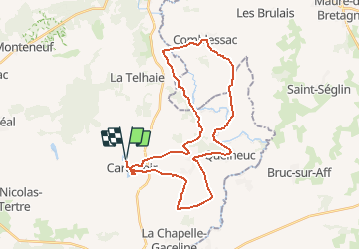
Trail Cycle of 33 km to be discovered at Brittany, Morbihan, Carentoir. This trail is proposed by tracegps.

Description

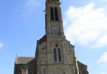
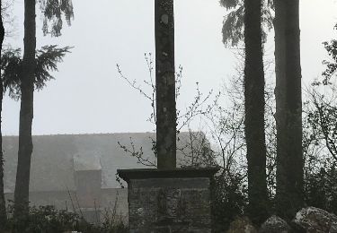
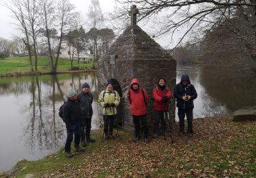
Circuit proposé par la maison du tourisme du Pays de Redon et Rando Breizh . Départ du parking de l’étang de Beauché. Le circuit est ponctué d’étapes patrimoine ou de loisirs : l’église du Temple et la Ferme du Monde à Carentoir, le Moulin de la Fosse et le site d’escalade dans les arbres « Aventure Parc » à Quelneuc. Retrouvez le plan et le descriptif sur le site de Rando Breizh.

Elevation profile

Photos

Positioning

Country:
France
Region :
Brittany
Department/Province :
Morbihan
Municipality :
Carentoir
Location:
Carentoir
Start:(UTM)
564515 ; 5296760 (30T) N.

Trails nearby

Trail Walking Carentoir - Quelneuc - Photo
Walking
vincent35

Walking

Very easy
Carentoir, Brittany, Morbihan, France
27 km | 32 km-effort
6h 48min
Yes
Trail Cycle Carentoir - Circuit de Tréal - Carentoir - Photo
Cycle
tracegps

Cycle

Medium
Carentoir, Brittany, Morbihan, France
21 km | 24 km-effort
1h 30min
Yes
Trail Walking Carentoir - Circuit de la Voie Ahée  - Carentoir - Photo
Walking
tracegps

Walking

Difficult
Carentoir, Brittany, Morbihan, France
13.8 km | 16.3 km-effort
3h 25min
Yes
Trail Walking Carentoir - carentoir - Photo
Walking
bourdet

Walking

Easy
Carentoir, Brittany, Morbihan, France
3.7 km | 4.1 km-effort
50min
Yes
Trail On foot Carentoir - 23/03/2019.Corrigé - CARENTOIR nord-ouest  - Photo
On foot
babeth35

On foot

Medium
Carentoir, Brittany, Morbihan, France
31 km | 37 km-effort
Unknown
Yes
Trail Walking Carentoir - 17.04.2019 corrigé - QUELNEUC et autour - Photo
Walking
babeth35

Walking

Medium
Carentoir, Brittany, Morbihan, France
23 km | 28 km-effort
6h 9min
Yes
Trail Walking Carentoir - 23/03/2019.Corrigé - CARENTOIR nord-ouest  - Photo
Walking
babeth35

Walking

Medium
Carentoir, Brittany, Morbihan, France
31 km | 38 km-effort
8h 11min
Yes
Trail Walking Carentoir - 23.03.2019 - CARENTOIR nord-ouest  - Photo
Walking
babeth35

Walking

Medium
Carentoir, Brittany, Morbihan, France
31 km | 36 km-effort
7h 53min
Yes
Trail Walking La Gacilly - la Chapelle Gaceline  - Photo
Walking
Pierre-yves Leclerc

Walking

Easy
La Gacilly, Brittany, Morbihan, France
11.4 km | 13.3 km-effort
13h 54min
Yes


Close
My subscriptions