


Olivier J1

DanielROLLET
User
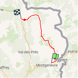

Length
15.7 km

Max alt
2531 m

Uphill gradient
755 m
Km-Effort
27 km

Min alt
1488 m

Downhill gradient
1114 m
Boucle
No
Creation date :
2019-05-06 16:30:11.477
Updated on :
2019-05-06 16:30:11.477
5h16
Difficulty : Difficult

FREE GPS app for hiking
 SityTrail
IGN / Geographical institutes
SityTrail Plus
The world is yours!
About
Trail Walking of 15.7 km to be discovered at Provence-Alpes-Côte d'Azur, Hautes-Alpes, Montgenèvre. This trail is proposed by DanielROLLET.
Description
Rando ATC
Positioning
Country:
France
Region :
Provence-Alpes-Côte d'Azur
Department/Province :
Hautes-Alpes
Municipality :
Montgenèvre
Location:
Unknown
Start:(Dec)
Start:(UTM)
320760 ; 4978025 (32T) N.
Comments