Trail Walking Unknown - Mauritanie jour 01 - Photo

Mauritanie jour 01

 chrisgps
chrisgps

User

© OpenStreetMap contributors
Length
Length
16.6 km
Max alt
Max alt
534 m
Uphill gradient
Uphill gradient
281 m
Km-Effort
Km-Effort  
20 km
Min alt
Min alt
463 m
Downhill gradient
Downhill gradient
277 m
Boucle
Boucle
No
Creation date :
2019-05-08 15:15:55.394
Updated on :
2019-05-08 15:15:56.633

(0 Reviews)

Walking
Walking
8h06
Difficulty : Medium

Scan this QR Code to open this trail in the SityTrail application

FREE GPS app for hiking

Logo SityTrail SityTrail

IGN / Geographical institutes

Download SityTrail from the App Store Download SityTrail from Google Play

Logo SityTrail SityTrail World

The world is yours!

Download SityTrail from the App Store Download SityTrail from Google Play Download SityTrail on Huawei AppGallery

About

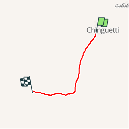
Trail Walking of 16.6 km to be discovered at Adrar. This trail is proposed by chrisgps.

Description

départ de Chinguetti, Oasis de Lagueila et Dunes de Mghalid

Elevation profile

Positioning

Country:
Mauritania
Region :
Adrar
Department/Province :
Unknown
Municipality :
Unknown
Location:
Unknown
Start:(UTM)
774299 ; 2263660 (28Q) N.

Trails nearby

Trail Walking  - Mauritanie jour 2 - Photo
Walking
chrisgps

Walking

Medium
, Adrar, , Mauritania
18.9 km | 23 km-effort
10h 2min
No


Close
My subscriptions