Trail Walking Bertangles - Circuit de l'arbre de May - Bertangles - Photo

Circuit de l'arbre de May - Bertangles

 tracegps
tracegps

User

© OpenStreetMap contributors
Length
Length
17.5 km
Max alt
Max alt
135 m
Uphill gradient
Uphill gradient
150 m
Km-Effort
Km-Effort  
19.5 km
Min alt
Min alt
59 m
Downhill gradient
Downhill gradient
150 m
Boucle
Boucle
Yes
Creation date :
2014-12-10 00:00:00.0
Updated on :
2014-12-10 00:00:00.0

(0 Reviews)

Walking
Walking
4h19
Difficulty : Very difficult

Scan this QR Code to open this trail in the SityTrail application

FREE GPS app for hiking

Logo SityTrail SityTrail

IGN / Geographical institutes

Download SityTrail from the App Store Download SityTrail from Google Play

Logo SityTrail SityTrail World

The world is yours!

Download SityTrail from the App Store Download SityTrail from Google Play Download SityTrail on Huawei AppGallery

About

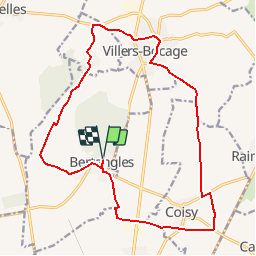
Trail Walking of 17.5 km to be discovered at Hauts-de-France, Somme, Bertangles. This trail is proposed by tracegps.

Description

Circuit proposé par la Mairie de Camon. Départ de l’église de Bertangles. A découvrir : Bertangles : Le château du XVIIIe s., église Villers Bocage : L'église Saint-Georges Montonvillers : Le château Retrouvez cette randonnée sur le site de la mairie, rubrique «Tourisme et loisirs».

Elevation profile

Photos

Positioning

Country:
France
Region :
Hauts-de-France
Department/Province :
Somme
Municipality :
Bertangles
Location:
Unknown
Start:(UTM)
449799 ; 5535739 (31U) N.

Trails nearby

Trail Walking Allonville - La Vallée de la Hayette - Allonville - Photo
Walking
tracegps

Walking

Easy
Allonville, Hauts-de-France, Somme, France
6.1 km | 6.7 km-effort
1h 30min
Yes
Trail Walking Allonville - Randonnée autour d'Allonville - Photo
Walking
tracegps

Walking

Medium
Allonville, Hauts-de-France, Somme, France
12.9 km | 14.5 km-effort
3h 0min
Yes
Trail Walking Bertangles - Circuit de l'arbre de May - Bertangles - Photo
Walking
Baltykatt

Walking

Very difficult
Bertangles, Hauts-de-France, Somme, France
17.5 km | 19.4 km-effort
4h 19min
Yes
Trail Other activity Allonville - Allonville 2017 - Photo
Other activity
jema.bernard

Other activity

Easy
Allonville, Hauts-de-France, Somme, France
12.6 km | 14.1 km-effort
2h 51min
Yes
Trail Walking Bertangles - Bertangles - Photo
Walking
Phil55

Walking

Very easy
Bertangles, Hauts-de-France, Somme, France
3.2 km | 3.6 km-effort
1h 35min
Yes
Trail Walking Villers-Bocage - Villers  - Photo
Walking
lr80

Walking

Very easy
Villers-Bocage, Hauts-de-France, Somme, France
14.8 km | 16.6 km-effort
3h 50min
Yes
Trail Walking Bertangles - montonvillers - Photo
Walking
Cheyenne80

Walking

Very easy
Bertangles, Hauts-de-France, Somme, France
13.5 km | 15.1 km-effort
3h 19min
Yes
Trail Motor Bertangles - pdk2016/3 - Photo
Motor
olivieraron

Motor

Very easy
Bertangles, Hauts-de-France, Somme, France
250 km | 287 km-effort
10h 0min
No
Trail Other activity Bertangles - bertangles dunkerque - Photo
Other activity
olivieraron

Other activity

Very easy
Bertangles, Hauts-de-France, Somme, France
234 km | 267 km-effort
8h 20min
No


Close
My subscriptions