Trail Walking Allonville - La Vallée de la Hayette - Allonville - Photo

La Vallée de la Hayette - Allonville

 tracegps
tracegps

User

© OpenStreetMap contributors
Length
Length
6.1 km
Max alt
Max alt
107 m
Uphill gradient
Uphill gradient
48 m
Km-Effort
Km-Effort  
6.7 km
Min alt
Min alt
69 m
Downhill gradient
Downhill gradient
48 m
Boucle
Boucle
Yes
Creation date :
2014-12-10 00:00:00.0
Updated on :
2014-12-10 00:00:00.0

(0 Reviews)

Walking
Walking
1h30
Difficulty : Easy

Scan this QR Code to open this trail in the SityTrail application

FREE GPS app for hiking

Logo SityTrail SityTrail

IGN / Geographical institutes

Download SityTrail from the App Store Download SityTrail from Google Play

Logo SityTrail SityTrail World

The world is yours!

Download SityTrail from the App Store Download SityTrail from Google Play Download SityTrail on Huawei AppGallery

About

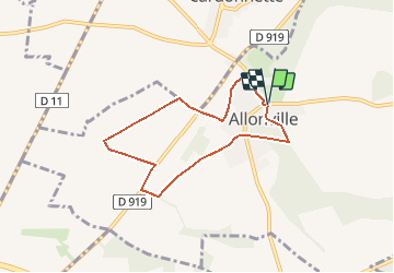
Trail Walking of 6.1 km to be discovered at Hauts-de-France, Somme, Allonville. This trail is proposed by tracegps.

Description

Circuit proposé par la Mairie de Camon. Départ de l’église d’Allonville. A découvrir le monument "les châtiments de Victor Hugo". Retrouvez cette randonnée sur le site de la mairie, rubrique « Tourisme et loisirs ».

Elevation profile

Photos

Positioning

Country:
France
Region :
Hauts-de-France
Department/Province :
Somme
Municipality :
Allonville
Location:
Unknown
Start:(Dec)
Start:(UTM)
454426 ; 5532286 (31U) N.

Trails nearby

Trail Walking Bertangles - Circuit de l'arbre de May - Bertangles - Photo
Walking
tracegps

Walking

Very difficult
Bertangles, Hauts-de-France, Somme, France
17.5 km | 19.5 km-effort
4h 19min
Yes
Trail Walking Amiens - amiens camon amiens par les hortillonnages - Photo
Walking
stef789

Walking

Very easy
Amiens, Hauts-de-France, Somme, France
8.4 km | 9.2 km-effort
2h 12min
Yes
Trail Walking Allonville - Randonnée autour d'Allonville - Photo
Walking
tracegps

Walking

Medium
Allonville, Hauts-de-France, Somme, France
12.9 km | 14.5 km-effort
3h 0min
Yes
Trail Walking Amiens - BB230810 somme - Photo
Walking
bebenoit83

Walking

Medium
Amiens, Hauts-de-France, Somme, France
6.6 km | 7 km-effort
1h 28min
Yes
Trail On foot Amiens - SityTrail - Amiens Hortillonnages - Photo
On foot
rvs147

On foot

Very easy
Amiens, Hauts-de-France, Somme, France
9.3 km | 10.2 km-effort
Unknown
Yes
Trail Walking Bertangles - Circuit de l'arbre de May - Bertangles - Photo
Walking
Baltykatt

Walking

Very difficult
Bertangles, Hauts-de-France, Somme, France
17.5 km | 19.4 km-effort
4h 19min
Yes
Trail Other activity Allonville - Allonville 2017 - Photo
Other activity
jema.bernard

Other activity

Easy
Allonville, Hauts-de-France, Somme, France
12.6 km | 14.1 km-effort
2h 51min
Yes
Trail Cycle Amiens - de amiens ... - Photo
Cycle
Bernard.voyageur

Cycle

Easy
Amiens, Hauts-de-France, Somme, France
9.7 km | 10.6 km-effort
1h 18min
No
Trail Quad Amiens - 120623_hortillonages - Photo
Quad
d.rognon

Quad

Very easy
Amiens, Hauts-de-France, Somme, France
3 km | 3.2 km-effort
47min
Yes


Close
My subscriptions