


190317_Saint Hippolyte_24,5-960+

Anthony-67
User
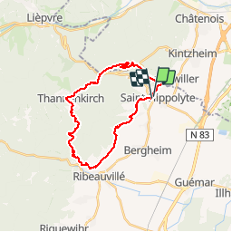

Length
25 km

Max alt
726 m

Uphill gradient
934 m
Km-Effort
37 km

Min alt
248 m

Downhill gradient
936 m
Boucle
Yes
Creation date :
2019-05-06 22:41:30.664
Updated on :
2019-05-06 22:41:30.664
6h15
Difficulty : Medium

FREE GPS app for hiking
 SityTrail
IGN / Geographical institutes
SityTrail Plus
The world is yours!
About
Trail Walking of 25 km to be discovered at Grand Est, Haut-Rhin, Saint-Hippolyte. This trail is proposed by Anthony-67.
Photos

Positioning
Country:
France
Region :
Grand Est
Department/Province :
Haut-Rhin
Municipality :
Saint-Hippolyte
Location:
Unknown
Start:(Dec)
Start:(UTM)
378661 ; 5343473 (32U) N.
Comments