Trail Equestrian Lafage-sur-Sombre - Sur les traces du Tacot - Lafage sur Sombre - Pays d'Egletons  - Photo

Sur les traces du Tacot - Lafage sur Sombre - Pays d'Egletons

 tracegps
tracegps

User

© OpenStreetMap contributors
Length
Length
7.9 km
Max alt
Max alt
663 m
Uphill gradient
Uphill gradient
120 m
Km-Effort
Km-Effort  
9.6 km
Min alt
Min alt
595 m
Downhill gradient
Downhill gradient
122 m
Boucle
Boucle
Yes
Creation date :
2014-12-10 00:00:00.0
Updated on :
2014-12-10 00:00:00.0

(0 Reviews)

Equestrian
Equestrian
1h10
Difficulty : Medium

Scan this QR Code to open this trail in the SityTrail application

FREE GPS app for hiking

Logo SityTrail SityTrail

IGN / Geographical institutes

Download SityTrail from the App Store Download SityTrail from Google Play

Logo SityTrail SityTrail World

The world is yours!

Download SityTrail from the App Store Download SityTrail from Google Play Download SityTrail on Huawei AppGallery

About

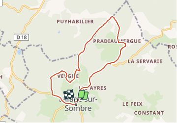
Trail Equestrian of 7.9 km to be discovered at New Aquitaine, Corrèze, Lafage-sur-Sombre. This trail is proposed by tracegps.

Description

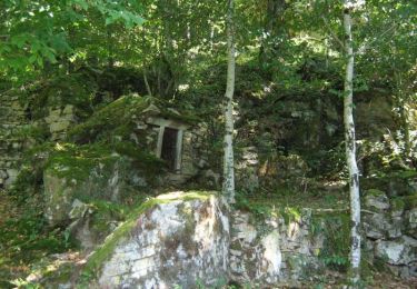
Sur les traces du Tacot - Lafage sur Sombre - Pays d'Égletons. Le Tacot, petit train à vapeur qui arpentât le premier cet itinéraire, marquait son passage avec son panache de fumée. Son souvenir est encore présent dans la mémoire de nos aînés. Retrouver, de-ci de-là, les vestiges de cette ligne de chemin de fer secondaire : Gare, citerne et tracé de l'ancienne voie ferrée qui, de 1913 à 1959, reliait Tulle à Ussel. Téléchargez la fiche du circuit sur le site du Conseil Général de la Corrèze. Renseignements : Communauté de Communes de Ventadour 05.55.27.69.26

Elevation profile

Photos

Positioning

Country:
France
Region :
New Aquitaine
Department/Province :
Corrèze
Municipality :
Lafage-sur-Sombre
Location:
Unknown
Start:(UTM)
427209 ; 5016093 (31T) N.

Trails nearby

Trail Walking Lafage-sur-Sombre - Bois et moulins - Lafage sur Sombre - Pays d'Egletons  - Photo
Walking
tracegps

Walking

Medium
(1)
Lafage-sur-Sombre, New Aquitaine, Corrèze, France
6.9 km | 8.7 km-effort
2h 0min
Yes
Trail On foot Le Jardin - Sur les chemins de Marcouyeux - Photo
On foot
PRO

On foot

Easy
Le Jardin, New Aquitaine, Corrèze, France
6.5 km | 8.1 km-effort
1h 50min
Yes
Trail On foot Le Jardin - Le Jardin Bourg - Photo
On foot
PRO

On foot

Easy
Le Jardin, New Aquitaine, Corrèze, France
4.4 km | 5.5 km-effort
1h 15min
Yes
Trail Walking Laval-sur-Luzège - Fred Laval sur luzege_1 - Photo
Walking
arnoultjf

Walking

Very easy
Laval-sur-Luzège, New Aquitaine, Corrèze, France
10.7 km | 13.9 km-effort
3h 22min
Yes
Trail Walking Le Jardin - balade le jardin avec Viviane  - Photo
Walking
Nicole Cridel

Walking

Very easy
Le Jardin, New Aquitaine, Corrèze, France
4.3 km | 5.3 km-effort
1h 29min
Yes
Trail Mountain bike Lafage-sur-Sombre - Sur les traces du Tacot - Lafage sur Sombre - Pays d'Egletons  - Photo
Mountain bike
tracegps

Mountain bike

Medium
Lafage-sur-Sombre, New Aquitaine, Corrèze, France
7.9 km | 9.6 km-effort
40min
Yes
Trail Walking Lafage-sur-Sombre - Sur les traces du Tacot - Lafage sur Sombre - Pays d'Egletons  - Photo
Walking
tracegps

Walking

Medium
Lafage-sur-Sombre, New Aquitaine, Corrèze, France
7.9 km | 9.6 km-effort
3h 0min
Yes
Trail Mountain bike Lafage-sur-Sombre - Bois et moulins - Lafage sur Sombre - Pays d'Egletons  - Photo
Mountain bike
tracegps

Mountain bike

Medium
Lafage-sur-Sombre, New Aquitaine, Corrèze, France
6.9 km | 8.7 km-effort
30min
Yes
Trail Equestrian Le Jardin - Sur les chemins de Marcouyeux - Le Jardin - Pays d'Egletons  - Photo
Equestrian
tracegps

Equestrian

Medium
Le Jardin, New Aquitaine, Corrèze, France
6.4 km | 8 km-effort
1h 10min
Yes


Close
My subscriptions