Trail Walking Saint-Lézer - Les coteaux de Saint-Lézer  - Photo

Les coteaux de Saint-Lézer

 tracegps
tracegps

User

© OpenStreetMap contributors
Length
Length
11.9 km
Max alt
Max alt
344 m
Uphill gradient
Uphill gradient
195 m
Km-Effort
Km-Effort  
14.5 km
Min alt
Min alt
231 m
Downhill gradient
Downhill gradient
206 m
Boucle
Boucle
Yes
Creation date :
2014-12-10 00:00:00.0
Updated on :
2014-12-10 00:00:00.0

(0 Reviews)

Walking
Walking
3h00
Difficulty : Medium

Scan this QR Code to open this trail in the SityTrail application

FREE GPS app for hiking

Logo SityTrail SityTrail

IGN / Geographical institutes

Download SityTrail from the App Store Download SityTrail from Google Play

Logo SityTrail SityTrail World

The world is yours!

Download SityTrail from the App Store Download SityTrail from Google Play Download SityTrail on Huawei AppGallery

About

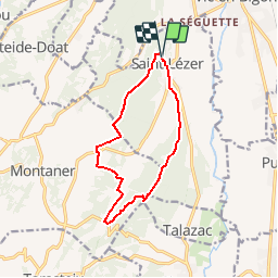
Trail Walking of 11.9 km to be discovered at Occitania, Hautespyrenees, Saint-Lézer. This trail is proposed by tracegps.

Description

Circuit proposé par la communauté de communes de Vic-Montaner et l'Office de Tourisme de Vic-Montaner. Départ: Parking de l'église de Saint-Lézer . Sur les coteaux boisés à l'ouest du Val d'Adour ce parcours partant du site gallo-romain de Saint-Lézer offre un magnifique point de vue sur les Pyrénées. Retrouvez le circuit et son descriptif sur le site de l'office de Tourisme de Vic-Montaner.

Elevation profile

Photos

Positioning

Country:
France
Region :
Occitania
Department/Province :
Hautespyrenees
Municipality :
Saint-Lézer
Location:
Unknown
Start:(UTM)
259365 ; 4806416 (31T) N.

Trails nearby

Trail On foot Montaner - MONTANER La Milouloise M2 82 ans le 5/02/2020 - Photo
On foot
GUIDE
marmotte65

On foot

Easy
Montaner, New Aquitaine, Pyrénées-Atlantiques, France
7 km | 8.7 km-effort
Unknown
Yes
Trail Walking Montaner - MONTANER 85 Ans de JC - Photo
Walking
GUIDE
marmotte65

Walking

Medium
Montaner, New Aquitaine, Pyrénées-Atlantiques, France
6.7 km | 8.9 km-effort
1h 50min
Yes
Trail Mountain bike Saint-Lézer - Les coteaux de Saint-Lézer  - Photo
Mountain bike
tracegps

Mountain bike

Easy
Saint-Lézer, Occitania, Hautespyrenees, France
11.9 km | 14.5 km-effort
1h 0min
Yes
Trail On foot Talazac - Variante GR 101 - Photo
On foot
PRO

On foot

Easy
Talazac, Occitania, Hautespyrenees, France
8.9 km | 11 km-effort
2h 30min
No
Trail On foot Saint-Lézer - SityTrail - Les coteaux de Saint-Lézer  - Photo
On foot
GUIDE
marmotte65

On foot

Easy
Saint-Lézer, Occitania, Hautespyrenees, France
10.1 km | 12.4 km-effort
2h 49min
Yes
Trail Walking Montaner - RS Montaner 2021 - Photo
Walking
LouisROGER

Walking

Easy
Montaner, New Aquitaine, Pyrénées-Atlantiques, France
4.4 km | 5.8 km-effort
1h 23min
Yes
Trail Walking Montaner - Les coteaux de Montaner - Photo
Walking
tracegps

Walking

Medium
Montaner, New Aquitaine, Pyrénées-Atlantiques, France
10.7 km | 14.1 km-effort
2h 45min
Yes
Trail Walking Vic-en-Bigorre - Vic en Bigorre - Ladevèse et Sannous - Photo
Walking
marcel.F

Walking

Easy
Vic-en-Bigorre, Occitania, Hautespyrenees, France
8.3 km | 10 km-effort
1h 54min
Yes
Trail Walking Lamayou - Lamayou - Peyraube et Lalaye - Photo
Walking
marcel.F

Walking

Difficult
Lamayou, New Aquitaine, Pyrénées-Atlantiques, France
10.7 km | 12.6 km-effort
2h 51min
Yes


Close
My subscriptions