Trail Walking Châteauponsac - Sentier des Narcisses - Châteauponsac  - Photo

Sentier des Narcisses - Châteauponsac

 tracegps
tracegps

User

© OpenStreetMap contributors
Length
Length
9.6 km
Max alt
Max alt
301 m
Uphill gradient
Uphill gradient
189 m
Km-Effort
Km-Effort  
12.1 km
Min alt
Min alt
216 m
Downhill gradient
Downhill gradient
189 m
Boucle
Boucle
Yes
Creation date :
2014-12-10 00:00:00.0
Updated on :
2014-12-10 00:00:00.0

(0 Reviews)

Walking
Walking
2h15
Difficulty : Medium

Scan this QR Code to open this trail in the SityTrail application

FREE GPS app for hiking

Logo SityTrail SityTrail

IGN / Geographical institutes

Download SityTrail from the App Store Download SityTrail from Google Play

Logo SityTrail SityTrail World

The world is yours!

Download SityTrail from the App Store Download SityTrail from Google Play Download SityTrail on Huawei AppGallery

About

Trail Walking of 9.6 km to be discovered at New Aquitaine, Haute-Vienne, Châteauponsac. This trail is proposed by tracegps.

Description

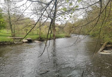
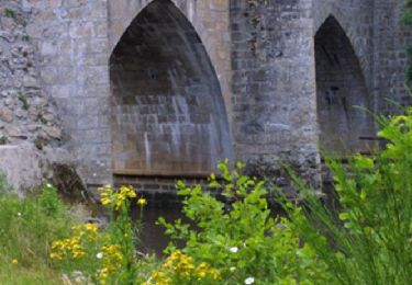
Circuit proposé par le Comité Départemental du Tourisme de la Haute-Vienne sur le site www.randonnee-hautevienne.com . Sentier des Narcisses – Châteauponsac. Départ : A l'Office de Tourisme, place Mazurier. Le sentier des narcisses propose une très belle balade à Châteauponsac au bord de la Gartempe. ... Les points forts de la Rando : Le vieux Châteauponsac ; le faubourg du Moustier ; le village d'Auzillac ; la porte Peyrine ; la chapelle Notre Dame de Toute Bonté. Téléchargez la fiche du circuit sur le site Randonnée en Haute Vienne.

Elevation profile

Photos

Positioning

Country:
France
Region :
New Aquitaine
Department/Province :
Haute-Vienne
Municipality :
Châteauponsac
Location:
Unknown
Start:(UTM)
366830 ; 5110395 (31T) N.

Trails nearby

Trail Walking Châteauponsac - Ballade du soir - Photo
Walking
Philou888

Walking

Easy
Châteauponsac, New Aquitaine, Haute-Vienne, France
4 km | 5.9 km-effort
1h 13min
No
Trail Walking Châteauponsac - Châteauponsac - Sentier du Petit Monteil et de Lavalette - 7,6 km - Photo
Walking
bernard_ostermann

Walking

Medium
Châteauponsac, New Aquitaine, Haute-Vienne, France
7.6 km | 9.3 km-effort
1h 55min
Yes
Trail Walking Châteauponsac - Châteauponsac - Sentier de Létrade - 5,6 km - Photo
Walking
bernard_ostermann

Walking

Easy
Châteauponsac, New Aquitaine, Haute-Vienne, France
5.7 km | 8 km-effort
1h 36min
Yes
Trail Walking Châteauponsac - Sentier de Létrade - Châteauponsac  - Photo
Walking
tracegps

Walking

Easy
Châteauponsac, New Aquitaine, Haute-Vienne, France
5.7 km | 8 km-effort
1h 30min
Yes
Trail Walking Châteauponsac - Grande boucle - Le chemin de l'Osmonde Royale - Châteauponsac  - Photo
Walking
tracegps

Walking

Difficult
Châteauponsac, New Aquitaine, Haute-Vienne, France
27 km | 35 km-effort
8h 0min
Yes
Trail Equestrian Châteauponsac - Sentier du Petit Monteil et de Lavalette - Châteauponsac  - Photo
Equestrian
tracegps

Equestrian

Medium
Châteauponsac, New Aquitaine, Haute-Vienne, France
7.6 km | 9.3 km-effort
1h 19min
Yes
Trail Mountain bike Châteauponsac - Sentier du Petit Monteil et de Lavalette - Châteauponsac  - Photo
Mountain bike
tracegps

Mountain bike

Medium
(1)
Châteauponsac, New Aquitaine, Haute-Vienne, France
7.6 km | 9.3 km-effort
45min
Yes
Trail Walking Châteauponsac - Sentier du Petit Monteil et de Lavalette - Châteauponsac  - Photo
Walking
tracegps

Walking

Medium
Châteauponsac, New Aquitaine, Haute-Vienne, France
7.6 km | 9.3 km-effort
2h 15min
Yes
Trail Walking Châteauponsac - Le sentier de Chênepierre - Chateauponsac  - Photo
Walking
tracegps

Walking

Medium
Châteauponsac, New Aquitaine, Haute-Vienne, France
8.9 km | 11.3 km-effort
2h 15min
Yes


Close
My subscriptions