


Wildenstein -Col du Pourri-Faing-Col du Bockloch

JCLUTT
User
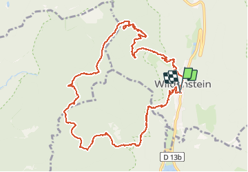

Length
13.2 km

Max alt
1105 m

Uphill gradient
593 m
Km-Effort
21 km

Min alt
566 m

Downhill gradient
595 m
Boucle
Yes
Creation date :
2019-05-21 17:16:56.092
Updated on :
2020-08-19 07:51:38.958
5h48
Difficulty : Difficult

FREE GPS app for hiking
 SityTrail
IGN / Geographical institutes
SityTrail Plus
The world is yours!
About
Trail Walking of 13.2 km to be discovered at Grand Est, Haut-Rhin, Wildenstein. This trail is proposed by JCLUTT.
Description
Très belle randonnée, un peu sportive, dans le massif du Ventron.
Positioning
Country:
France
Region :
Grand Est
Department/Province :
Haut-Rhin
Municipality :
Wildenstein
Location:
Unknown
Start:(Dec)
Start:(UTM)
347820 ; 5315766 (32T) N.
Comments