Trail Walking Lanouaille - Promenade des 3P à Lanouaille - Photo

Promenade des 3P à Lanouaille

 tracegps
tracegps

User

© OpenStreetMap contributors
Length
Length
7 km
Max alt
Max alt
324 m
Uphill gradient
Uphill gradient
162 m
Km-Effort
Km-Effort  
9.2 km
Min alt
Min alt
227 m
Downhill gradient
Downhill gradient
156 m
Boucle
Boucle
Yes
Creation date :
2014-12-10 00:00:00.0
Updated on :
2014-12-10 00:00:00.0

(1 Reviews)

Walking
Walking
1h19
Difficulty : Easy

Scan this QR Code to open this trail in the SityTrail application

FREE GPS app for hiking

Logo SityTrail SityTrail

IGN / Geographical institutes

Download SityTrail from the App Store Download SityTrail from Google Play

Logo SityTrail SityTrail World

The world is yours!

Download SityTrail from the App Store Download SityTrail from Google Play Download SityTrail on Huawei AppGallery

About

Trail Walking of 7 km to be discovered at New Aquitaine, Dordogne, Lanouaille. This trail is proposed by tracegps.

Description

Circuit proposé par le comité d'animation touristique et culturelle du Pays de Lanouaille. Boucle au départ du parking bus de la Merlie sur la D704 direction Excideuil. Pontajembert est une halte charmante au bord de la Haute-Loue. Traversée de bois avec palombière. Découverte de 2 villages : Paulhiac, ses fermes et son ancien lavoir, Plagne et son ancien château dont ne subsiste qu’une chapelle circulaire (privé). Aux Landysses, demeure bourgeoise du XIXème.

Elevation profile

Photos

Positioning

Country:
France
Region :
New Aquitaine
Department/Province :
Dordogne
Municipality :
Lanouaille
Location:
Unknown
Start:(UTM)
353289 ; 5025789 (31T) N.

Comments

Please log in to post a review or rate the element


grosses erreurs de tracé


Trails nearby

Trail Walking Angoisse - Le bois de Rouffiac - Lanouaille - Photo
Walking
tracegps

Walking

Medium
Angoisse, New Aquitaine, Dordogne, France
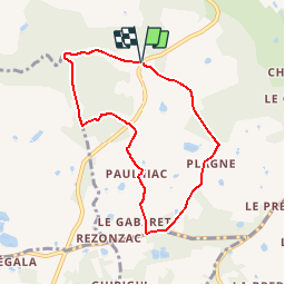
6.8 km | 7.9 km-effort
2h 0min
Yes
Trail Mountain bike Preyssac-d'Excideuil - Boucle du tacot à Preyssac d'Excideuil - Photo
Mountain bike
tracegps

Mountain bike

Easy
Preyssac-d'Excideuil, New Aquitaine, Dordogne, France
7.9 km | 9.6 km-effort
1h 0min
Yes
Trail Walking Preyssac-d'Excideuil - Boucle du tacot à Preyssac d'Excideuil - Photo
Walking
tracegps

Walking

Easy
Preyssac-d'Excideuil, New Aquitaine, Dordogne, France
7.9 km | 9.6 km-effort
2h 0min
Yes
Trail Walking Génis - Rand'Auvezere - Photo
Walking
NICOLEROBERT

Walking

Difficult
Génis, New Aquitaine, Dordogne, France
11.4 km | 15.9 km-effort
3h 8min
Yes
Trail Mountain bike Lanouaille - Promenade des 3P à Lanouaille - Photo
Mountain bike
tracegps

Mountain bike

Easy
(1)
Lanouaille, New Aquitaine, Dordogne, France
7 km | 9.2 km-effort
30min
Yes
Trail On foot Génis - Boucle des Côteaux et des Gorges - Photo
On foot
PRO

On foot

Easy
Génis, New Aquitaine, Dordogne, France
5.2 km | 6 km-effort
1h 22min
No
Trail Walking Angoisse - rouffiac 3 - Photo
Walking
yvonbescond

Walking

Very easy
Angoisse, New Aquitaine, Dordogne, France
6.6 km | 7.7 km-effort
3h 40min
Yes
Trail Walking Dussac - Dussac Foucauld 10km - Photo
Walking
YV24

Walking

Easy
(1)
Dussac, New Aquitaine, Dordogne, France
9.9 km | 12.4 km-effort
2h 43min
Yes
Trail Walking Preyssac-d'Excideuil - Preyssac d'Excideuil Tacot 8km - Photo
Walking
YV24

Walking

Very easy
Preyssac-d'Excideuil, New Aquitaine, Dordogne, France
7.9 km | 9.6 km-effort
2h 4min
Yes


Close
My subscriptions